Deben entrance 2024

Johnah

Well-known member
Joined
28 Apr 2019
Messages
105
Visit site
Hmm, maybe an idea to wait for the official ECP chartlet? Not sure about that direction you show between the Knoll Spit buoy and the shore. Also, when leaving the bar shouldn't the direction be towards the Woodbridge Haven SWB?

Before the Deben SH buoy was moved, it denoted the corner of the knolls to the East and we don't have that now.

I went over it all twice today (4 crossings) writing down the depths as I stayed fairly close to the buoys and came back in to the NW shore on a similar heading. The depths around the Knoll Spit buoy varied quite a lot, indicating a channel there, but I am not sure where it is.

The minimum depths I found were around that Knoll Spit buoy and not at the bar close to the Mid Knoll SH buoy furthest out.

Having said that, there was plenty of depth 2 hours before HW, but in leaving the Deben you almost feel that you ought to head straight for the Knoll Spit PH buoy and there may be a danger of getting very close to the sand that the Deben starboard hand buoy used to protect us from. I left at -2H HW and came back in at HW.

I will get some photos at the next spring tide and we can have a look, but watch your echo-sounder close to the Knoll Spit buoy.

The photo shows the West Knoll PH buoy and centre distance the moved Deben PHB which is steering us away from the new knoll to the right of the mast with the seagulls. It is just breaking the surface on the neap tide HW.

Just to the left of the Deben SH buoy you can just see the re-positioned Knoll Spit PH buoy.

20240505_191405.jpg

John
 
Last edited:

Johnah

Well-known member
Joined
28 Apr 2019
Messages
105
Visit site
If you can fancy a slow sail out of the Deben, this was my first crossing after the buoys were finally in position for 2024.

Spoiler alert, in case you can't stand the excitement, the shallowest part I found was before the Knoll Spit Port Hand Buoy which is the one nearest the Martello Tower.

There may be a deeper channel somewhere, but this is what you get if you stay close to the buoys.

John


I Wright

New member
Joined
23 May 2021
Messages
12
Visit site
If you can fancy a slow sail out of the Deben, this was my first crossing after the buoys were finally in position for 2024.

Spoiler alert, in case you can't stand the excitement, the shallowest part I found was before the Knoll Spit Port Hand Buoy which is the one nearest the Martello Tower.

There may be a deeper channel somewhere, but this is what you get if you stay close to the buoys.

John

Dear John

Many thanks for this it is of great benefit as a chart has not been released as yet. My only question is what was the predicted tide height on the day you crossed. We are hoping to leave this Saturday and return Sunday but one boat has a draft of 1.8m and needs to reach the tide mill in one run so looking at crossing say 3hrs before high tide on Sunday

Cheers Irvine
 

DougTheMac

New member
Joined
4 May 2024
Messages
3
Visit site
We came in today at about 11 (50min before a 3.7m HW) in a 13m MoBo (1.3m draft). It was very straightforward, albeit perfect conditions. I believe the Mid Knoll SHB marks the end of the curving spit (someone above said that used to be the function of the safe water buoy? Not sure about that). Anyway, leaving that to stbd and turning onto the transit of the two reds, the green Deben buoy is only just open, and there is a disconcertingly high lump of bird perch very close to stbd as you approach the green. So, we basically followed a gentle S, leaving the first red close to port, keeping well away from aforesaid lump, and passing closer to the red than the green. After the second red, we continued on the same heading towards the shore, as there was a large patch of disturbed water to stbd. This was very much the shallowest bit - c0.5m at CD? The bit between the buoys was very deep - at 2-2.5m at CD. Perhaps I took the wrong heading from the second red, but it would be useful to have another green to indicate when it is safe to turn N.
 

Johnah

Well-known member
Joined
28 Apr 2019
Messages
105
Visit site
Hi Irvine, I wrote down the Harwich Harbour tide gauge reading but it is on the boat, however the photos below show what is lurking beneath the surface at +0.4m above CD at Wadgate Ledge. So I think there is plenty of water so long as you keep to the right line.

Hi Doug, some photos below at LWS +0.4m above CD this morning 8th May and the sand isn't showing at the Knoll Spit where I think the shallowest section is. I thought it might be +0.2m above CD when I went across, but it needs checking.

From the last photo, maybe not a good idea to take a straight line from the Knoll Spit buoy to the Ferry!

As always, check with John White if you are not sure.

John


DJI_0412.jpgDJI_0415.jpgDJI_0421.jpg
 

I Wright

New member
Joined
23 May 2021
Messages
12
Visit site
And finally, the seagull view.
Dear John

Thanks for this will be going out about 2 1/2 hrs before high water Saturday & coming back maybe 3 hrs before high water Sunday (depending on what depths we find Saturday)

Cheers Irvine

(boat name Alana) Sun odyssey 32
 

PeterR

Member
Joined
12 Dec 2009
Messages
418
Visit site
Thanks to all those who got the Deben Bar Chartlet published and to Jonah for his drone view of the Bar on a Spring LW tide. They were particularly welcome as I saw them on the 8th when I was due to launch from Larkmans on the 9th.

I did not get away until 13:45 which was already 30 minutes after HW on the bar (13:16). It normally takes me between an hour twenty minutes to an hour and a half to reach the bar which after this late start indicated I would be crossing between one and three quarters of an hour and 2 hours after HW at Woodbridge Haven. Tide Times was predicting a height of tide of 2.82 metres at 1 hr 45 mins and 2.61 metres at 2 hours after HW. The latter being a bit tight with a 2 metre draft, unless the depth at chart datum increased the safety margin. The chartlet showed CD ought to be 0.5 metres but it didn’t look as if you needed to stray very far before that went down to 0.3 metres. There didn’t seem to be much tidal surge to help, 0.1 metres at the most, but I decided to give it a go and see what time I got there and what it looked like.

The 9th was a beautiful day, forecast to be sunny and warm with just a gentle southerly wind and so it was up in Woodbridge. Once past Woodbridge marina I opened the throttle to maximum cruising revs and with a clean hull and prop was getting 7 knots boat speed, although as the tide was still flooding in the upper part of the river ground speed was more like 6.5 knots. Around Ramsholt the ebb set in and I was soon doing about 8.5 knots over the ground. By this time the apparent wind was over 20 knots and I needed an oilskin jacket. With such a strong ebb I was making good progress and in what looked like flat conditions decide to give it a go. There was a large motorboat about 400 yards ahead and whilst she probably didn’t draw all that much I thought she would provide a good steer as to where the buoys were. I decided to try and follow the darker coloured water on Jonahs drone pictures so moved across the river soon after passing the Martello tower and approached Knoll Spit from roughly where 1.5m is shown on the chartlet. By that time I was doing about eleven knots over the ground and it took quite a sharp turn to head toward Deben buoy and a few seconds later another sharp turn to stay on track for West Knoll then only a few more seconds before another sharp turn to head for Mid Knoll. I was having to concentrate so hard on avoiding navigation buoys that I was not really paying that much attention to the depth. Around Knoll Spit I did not see less than 4.7 metres and it stayed that deep or deeper out to West Knoll only reducing to 3.7 metres just before Mid Knoll. There might have been shallower patches that I missed but that is what I saw.

I must admit to feeling somewhat shell shocked when I cleared Mid Knoll at 15.00. The water had got quite rough between West Knoll and Mid knoll. I would have liked to have closed the hatch but I didn't dare leave the helm. I estimate the whole passage from Knoll Spit to Mid Knoll took less than four minutes.

The depth of 3.7 meters I found at Mid Knoll corresponded very closely with the predicted depth of 2.82 metres + 0.7 metres to 0.8 metres at chart datum + 0.1 metres for tidal surge. However the 4.7 meters depth I found at Knoll Spit only makes sense if the 1.5 metre patch I was aiming for is actually a channel of that depth going between the shallower patches shown as 0.5 and 0.9 metres. I have no idea if I could reliably find it again.

I have been doing this trip every year for the last 30 years. I have done it with less water and rougher water but I have never done it so fast and with such abrupt changes of course in mid channel. Mind you my crossing bore no relationship whatsoever to the placid view Jonah showed of his crossing on a neap flood.
 

Johnah

Well-known member
Joined
28 Apr 2019
Messages
105
Visit site
Well done Peter, you work it out very carefully. There is still some checking to be done around the Knoll Spit buoy to see if the depths are better if cleared by a larger margin.

Photo of the first grounding this morning just by the Deben buoy.

Oops.

JohnIMG-20240511-WA0001.jpg
 

DougTheMac

New member
Joined
4 May 2024
Messages
3
Visit site
We came out just after HW on 9th (a couple of hours before PeterR) - very benign, lots of depth, shallowest bit estimated to be c0.5m just in from the inner red. With the benefit of the now-published chartlet (ain't 'tinterweb marvellous!), I took a line from Martello U towards the inner red, slightly N of when I entered, and there was definitely more depth. It was still flooding very hard past the ferry etc, which probably kept the water flat - cF3/4 Southerly against the ebb must have made PeterR's exit lumpy.

Which makes me ask the following of those who know the entrance better than I:
(1) When (relative to HW Woodbridge Haven) does the ebb start at the mouth of the river and especially over the bar?
(2) Has this changed this year? It was noticeable up at Tidemill that the water level seemed to be lower/later than their published predictions - not carefully logged, but definitely so that day, and not due to the high lowering levels (as PeterR noted, the surge was slightly +ve).

I wonder if the bar in general (not just the channel) is shallower than usual and restricting the flow of water in/out of the estuary, which would have the effect of making the rise and fall of tide inside both less and later than usual.

Any comments?
 

WF36

Well-known member
Joined
28 Jan 2009
Messages
1,157
Location
Suffolk
Visit site
Well done Peter, you work it out very carefully. There is still some checking to be done around the Knoll Spit buoy to see if the depths are better if cleared by a larger margin.

Photo of the first grounding this morning just by the Deben buoy.

Oops.

John
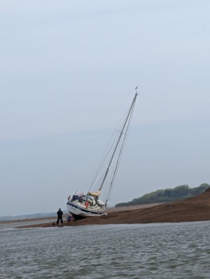
Allegedly got fishing gear wrapped around prop at night.


1.jpg
 

Johnah

Well-known member
Joined
28 Apr 2019
Messages
105
Visit site
Hi Doug, in the Ferry Sailing Club we normally estimate that the Deben river ebb starts about 1/2 hour after the theoretical high tide time. If you are coming in the river at high tide there will often be a fair tide helping you in just after HW, but when it turns it runs out pretty fast!

We don't think the bar is shallower than usual, in fact yesterday one of our most experienced sailors measured it and found that the bar bed level was -0.4m below CD and that is deep for the bar.

However, he also measured the shallow section near the Knoll Spit buoy and found it to be -0.1m below CD. So that is the shallowest part that we have found and we will use the minimum bed depth as Chart Datum. This might change!

By referring to the Harwich Harbour Authority Live Data tide height web page we then see the actual height of water every 10 minutes at Wadgate Ledge and can get out of the river a lot earlier than -2hours HW. We normally don't come back in on a falling tide after about +1 hour just in case.......

Tide - Harwich Haven Authority

Don't take our way as the right way to do it, you calculate it your way, but it has worked for us for several years, and remember to add on a healthy safety margin for sitting down in waves and weather etc.

The channel is quite narrow this year.

John
 
Last edited:

I Wright

New member
Joined
23 May 2021
Messages
12
Visit site
Last month I saw on marine radar this small little surveying boat doing a lot of what looks like surveying of the haven entrance, dose any one know if it was surveying, what it was for

Cheers Irvine
 

Attachments

  • image001 (1).png
    image001 (1).png
    636.2 KB · Views: 32
  • image001.png
    image001.png
    621.1 KB · Views: 26
  • Screenshot_20240423_145851_Windy.jpg
    Screenshot_20240423_145851_Windy.jpg
    531.9 KB · Views: 23

I Wright

New member
Joined
23 May 2021
Messages
12
Visit site
On Saturday 11th 3 hrs before high water leaving deben kept close to felixstowe side then crossed towards Knoll spit on a transit from a point halfway between sailing club and Martello tower near to Knoll spit buoy is where we meet shallowest depth 2.7m followed buoyant outwards following a transit between West Knoll buoy and woodbridge haven bouy. Returned next day (Sunday) following same track in reverse but 2.5hrs before high water with again shallowest depth near Knoll spit buoy about 3.1m
 
Top