Imray to stop publishing paper charts

RunAgroundHard

Well-known member
Joined
20 Aug 2022
Messages
2,275
Visit site
As the whole gamut of navigational information goes online, digital subscription becomes dominant. They might not be able to compete digitally with other apps in their sector. They could also be eliminating significant overhead in order to better fund their digital ambitions.

Others in this forum have commented favourably about their Apps.
 

westward

New member
Joined
17 Jul 2017
Messages
22
Visit site
Just had an email stating Imray are to stop publishing paper charts from next year due to the increasing reliance on electronic navigation systems. Shame as I always preferred them to Admiralty charts which will then be the only backup available.
For any longer passage, I always use a paper chart to check my route. The reason for this is that obstacles do not disappear from a paper chart when you zoom out. I suspect part of the reason for Vesta's grounding during the Ocean Race was the navigator not being able to check the route on a paper chart. I don't know why this issue is not better addressed in electronic charts. I bought a couple of new Imray paper chart this year. Sorry to hear they are stopping.
 
Last edited:

requiem

Active member
Joined
20 Mar 2019
Messages
238
Visit site
I don't know why this issue is not better addressed in electronic charts.
Such an obstacle should not disappear when zoomed out, and in the official ENCs for the area the reefs are indeed visible when zoomed out. It is no different from having two paper charts of different scales, where a feature is on one but left off the other.

The closest issue that remains is the SCAMIN (Scale Minimum) attribute, which can result in items being dropped when zooming out if not set appropriately when the chart is compiled. For this reason users are advised to disable it when reviewing a route. Vestas was using 3rd party charts, and only licensed the complete set on one of the two computers they had aboard.
 

onesea

Well-known member
Joined
28 Oct 2011
Messages
3,830
Location
Solent based..
Visit site
Such an obstacle should not disappear when zoomed out,
However they do.

I use MemoryMap as they are Rasta Style charts alongside good old navionics which has some great, features.

@Roberto your almost selling them to me, the other option for home made us too print A4 and stick them together.

I don't have the patient's to do it for myself. I can generally remember enough and manage, only a few hiccups along the way.
 

dunedin

Well-known member
Joined
3 Feb 2004
Messages
13,986
Location
Boat (over winters in) the Clyde
Visit site
However they do.

I use MemoryMap as they are Rasta Style charts alongside good old navionics which has some great, features.

@Roberto your almost selling them to me, the other option for home made us too print A4 and stick them together.

I don't have the patient's to do it for myself. I can generally remember enough and manage, only a few hiccups along the way.
I also use Memory Map with raster charts on my iPad alongside Navionics on my main ships plotters. As you say, raster are better for some things - eg pinnacle rocks rising out of deep water, very difficult to spot in Navionics, particularly on a sunny day.

But be warned that raster charts, as used by Memory Map, Visit My Harbour etc, will almost certainly die when the equivalent paper charts are eventually withdrawn by UKHO. As noted above, it is making these source raster charts that is the expensive bit for both Imray and UKHO.
 

requiem

Active member
Joined
20 Mar 2019
Messages
238
Visit site
However they do.
Indeed, and it's hard to argue against that, but it's also something that can happen with paper.

If, for example, someone purchased a small-scale planning chart, then after reviewing it and purchasing more detailed charts for the areas that indicated potential hazards, then you might similarly miss a feature omitted from the planning chart. Chart error happens.

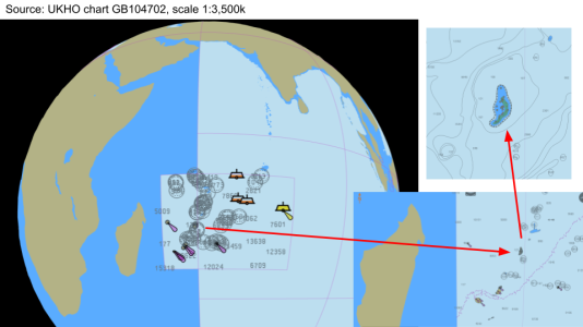
Some features should be called out, at least in some form, at all levels of zoom. Here's what I meant about the Cargados Carajos Shoals appearing on even the smallest-scale overview charts:

cargados.png
 

westward

New member
Joined
17 Jul 2017
Messages
22
Visit site
Such an obstacle should not disappear when zoomed out, and in the official ENCs for the area the reefs are indeed visible when zoomed out. It is no different from having two paper charts of different scales, where a feature is on one but left off the other.

The closest issue that remains is the SCAMIN (Scale Minimum) attribute, which can result in items being dropped when zooming out if not set appropriately when the chart is compiled. For this reason users are advised to disable it when reviewing a route. Vestas was using 3rd party charts, and only licensed the complete set on one of the two computers they had aboard.
I've never heard of Scale Minimum. Sounds like a useful thing. I don't see it anywhere in the menus of my plotter or in the Garmin doc. What system are you using? I suspect that the way Garmin charts are structured this wouldn't be possible.
 

requiem

Active member
Joined
20 Mar 2019
Messages
238
Visit site
I've never heard of Scale Minimum. Sounds like a useful thing. I don't see it anywhere in the menus of my plotter or in the Garmin doc. What system are you using? I suspect that the way Garmin charts are structured this wouldn't be possible.

You can find a few more details in this post: Role of SCAMIN on ENC

In brief, I'm using apps like SEAiq or OpenCPN with ENC charts from HOs, which is very different from what your average plotter supports.

Many of the questions people raise in these "charts are going away" discussions have already been hammered out as standards on the professional side for quite some years now. They have unfortunately largely been ignored on the leisure side.

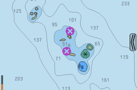
For example, the concept of the "isolated danger" indicator was introduced to tackle problems such as rock pinnacles that might otherwise be missed.
isolated-danger.jpeg
 

westward

New member
Joined
17 Jul 2017
Messages
22
Visit site
You can find a few more details in this post: Role of SCAMIN on ENC

In brief, I'm using apps like SEAiq or OpenCPN with ENC charts from HOs, which is very different from what your average plotter supports.

Many of the questions people raise in these "charts are going away" discussions have already been hammered out as standards on the professional side for quite some years now. They have unfortunately largely been ignored on the leisure side.

For example, the concept of the "isolated danger" indicator was introduced to tackle problems such as rock pinnacles that might otherwise be missed.
View attachment 185660
I am looking at replacing my present nav system which is based on two Garmin GPSmap 4008s. This system has served me well and took me round the world but the plotters are now classed as legacy products and are becoming less and less usable.
I have OpenCPN on a PC which I use for route planning and displaying grib files. The charts on this are out of date and there is no easy way to upgrade them.
I am quite keen on replacing this system with a PC based system using something like OpenCPN. What would you suggest? How easy is it to get HO charts? My boat is presently based in the Med. Where would I go for charts of this area? I like having the plotter on the binnacle as well as at the chart table. Do you have a suggestion of how to do that with a PC (or tablet I guess) based solution?
 

requiem

Active member
Joined
20 Mar 2019
Messages
238
Visit site
I am quite keen on replacing this system with a PC based system using something like OpenCPN. What would you suggest? How easy is it to get HO charts? My boat is presently based in the Med. Where would I go for charts of this area? I like having the plotter on the binnacle as well as at the chart table. Do you have a suggestion of how to do that with a PC (or tablet I guess) based solution?

For OpenCPN, I'd start with o-charts | Charts for OpenCPN for charts. The oeSENC products are (as best I understand) simply a package deal for an "unofficial" copy of official charts. The update frequency varies from country to country, e.g. it could be weekly or quarterly. (Also, as some posts have alluded to, official charts tend to be focused on commercial shipping; 3rd party products like Navionics may have better detail for areas of interest to leisure boaters.

You'll likely get better/current advice from places like CruisersForum, but the binnacle is one location for which the MFDs are well-suited. Absent a bimini or some sort of hood, a tablet-based solution runs the risk of not being bright enough, or even overheating in direct sun. (This also means you need to ensure the charging ability is enough to keep up with the screen at full brightness.) Similarly, most tablets don't dim sufficiently for night use. There are ways around this, such as the "reduce white point" option on iOS devices, but it requires a bit of digging.

One idea that comes to mind, should the budget permit, is an industrial display unit such as this one: 10.1" IP65 Touchscreen LCD Monitor HDMI, DVI, VGA & AV (I found the link from a very old post, so current market offerings may be much different, possibly even improved.)

If you have radar then retaining an MFD for it would also make sense. Some radars are supported by OpenCPN, but I like the idea of a more "direct" display for purposes of reliability and redundancy. For example, I'll often leave the MFD set to display radar whilst using phone or tablet for the chartwork.
 

westward

New member
Joined
17 Jul 2017
Messages
22
Visit site
For OpenCPN, I'd start with o-charts | Charts for OpenCPN for charts. The oeSENC products are (as best I understand) simply a package deal for an "unofficial" copy of official charts. The update frequency varies from country to country, e.g. it could be weekly or quarterly. (Also, as some posts have alluded to, official charts tend to be focused on commercial shipping; 3rd party products like Navionics may have better detail for areas of interest to leisure boaters.

You'll likely get better/current advice from places like CruisersForum, but the binnacle is one location for which the MFDs are well-suited. Absent a bimini or some sort of hood, a tablet-based solution runs the risk of not being bright enough, or even overheating in direct sun. (This also means you need to ensure the charging ability is enough to keep up with the screen at full brightness.) Similarly, most tablets don't dim sufficiently for night use. There are ways around this, such as the "reduce white point" option on iOS devices, but it requires a bit of digging.

One idea that comes to mind, should the budget permit, is an industrial display unit such as this one: 10.1" IP65 Touchscreen LCD Monitor HDMI, DVI, VGA & AV (I found the link from a very old post, so current market offerings may be much different, possibly even improved.)

If you have radar then retaining an MFD for it would also make sense. Some radars are supported by OpenCPN, but I like the idea of a more "direct" display for purposes of reliability and redundancy. For example, I'll often leave the MFD set to display radar whilst using phone or tablet for the chartwork.
Thanks for the advice. Good point about brightness and night sailing. I had thought about robustness and water proofing of tablets or screens but not that.
So does this mean that you have a hybrid system with both OpenCPN and Navionics or similar? This resembles what I have already. One of the problems is that Garmin charts are not readable by other systems including OpenCPN so that I have to have separate maps for that. This could be expensive especially if you are doing long distance cruising. Is there a solution where you can use the same charts on OpenCPN and your plotter?
Can you network your PC and your plotter? My plotters are on the NMEA network. My PC is linked by WiFi to my Vesper AIS which is the WiFi hub which is also connected to the NMEA network. However my PC can't talk to my plotters. I have to transfer routes to SD cards to upload routes to the plotters.
 

requiem

Active member
Joined
20 Mar 2019
Messages
238
Visit site
Can you network your PC and your plotter? My plotters are on the NMEA network. My PC is linked by WiFi to my Vesper AIS which is the WiFi hub which is also connected to the NMEA network. However my PC can't talk to my plotters. I have to transfer routes to SD cards to upload routes to the plotters.
I'm mainly on various club boats so configurations vary. Raymarine setups are nice, but their wifi doesn't pass NMEA data so you'd need to add a separate wifi (or ethernet) gateway. B&G wifi does allow NMEA, so with that my mobile devices can consume the instrument data directly. I would suspect your existing wifi hub similarly provides this functionality.

From recollection, in some cases OpenCPN can control an autopilot (i.e. sending commands to the control head). Sending routes to the plotters seems from a quick glance to be more problematic. I've heard mention of B&G having an anonymous FTP option that would let you upload directly to the plotter (or to the inserted memory card). Similarly, OpenCPN has a way to export route and waypoint information to Garmin hardware, but I'd treat that as a rumor until you can find someone who can reliably get it working.

Sharing charts is messier: if you use 3rd party charts like Navionics, they'll only want to share within their own ecosystem of apps/hardware, and even partition that between plotters and mobile apps. ENC charts are often licensed with very tight copy-prevention controls, meaning you can only use them on two specific systems, or sometimes with a portable dongle. The root of this issue is copyright control, which makes it rather intractable.
 

westward

New member
Joined
17 Jul 2017
Messages
22
Visit site
I'm mainly on various club boats so configurations vary. Raymarine setups are nice, but their wifi doesn't pass NMEA data so you'd need to add a separate wifi (or ethernet) gateway. B&G wifi does allow NMEA, so with that my mobile devices can consume the instrument data directly. I would suspect your existing wifi hub similarly provides this functionality.

From recollection, in some cases OpenCPN can control an autopilot (i.e. sending commands to the control head). Sending routes to the plotters seems from a quick glance to be more problematic. I've heard mention of B&G having an anonymous FTP option that would let you upload directly to the plotter (or to the inserted memory card). Similarly, OpenCPN has a way to export route and waypoint information to Garmin hardware, but I'd treat that as a rumor until you can find someone who can reliably get it working.

Sharing charts is messier: if you use 3rd party charts like Navionics, they'll only want to share within their own ecosystem of apps/hardware, and even partition that between plotters and mobile apps. ENC charts are often licensed with very tight copy-prevention controls, meaning you can only use them on two specific systems, or sometimes with a portable dongle. The root of this issue is copyright control, which makes it rather intractable.
Thanks for this reply. I could basically use my PC with OpenCPN as my navigation. It gets the position from the Vesper and displays AIS targets as well. I can also use it to display grib files and theoretically even do routing using the grib files (it doesn't work for small cruising boats in my limited experience). In fact it is already my backup nav system.
I could ditch the Garmin plotters and simply get current maps for OpenCPN. I don't control the auto-pilot from the plotters, though it is possible with the Garmin system as long as I am motoring. My problem is having an active device on the binnacle in this configuration. I haven't seen any practical robust way to do this yet which doesn't mean having what is effectively a second nav system.
I have some neighbours in the marina who have an Octopus system which runs on a PC. However they don't have any nav display at all in the cockpit except the usual course, speed, wind readouts. OK if you have a crew but I am usually single handed.
 

servus

Member
Joined
29 Jan 2024
Messages
49
Visit site
This discussion has gone - as many others - into a rather technical direction. While this is very interesting and might produce some good ideas for how to get on with the digital vehicle I wonder if there could be any other reason to go away from durable (see papyrus scrolls) forms of data storage to methods which are basicly self destructing, given some time.

When i look around amongst my friends, aquaintances whatever the relation might be, I see holiday-, family-, sportphotographs nearly only on screens, hardly ever printed any more. I guess in a not so far future our era will be known to the historians as the "time without picture documents".

What does it need to destroy a book? Fire, water, rot, mice ... all must attack the very book in it's storage location.

What does it take to eradicate the information on a digital data carrier? A magnetic field, a built_ and programmed in expiry date, a mad hacker or a not so mad one who sells me a programme to prevent his own destructive softwae from doing it's job?

Is it all about convenience, costs and ease of processing data or are we watching another gradual burning of Alexandria's library?

I also can build a three dimensional image from a two dimensional map/chart; I also like paper and the touch of it and so on. But this is personal, I learnt it at school, we were sent out to draw primitive maps by compass bearings and range estimation.
Just wondering....

I agree totally with @Sandy : Utter madness!
 

lustyd

Well-known member
Joined
27 Jul 2010
Messages
12,424
Visit site
Even when we used to use magnetic storage magnets didn’t affect it. That was a decade ago though.
If you think photos and charts are durable try leaving one in the sun for a while.
 

Roberto

Well-known member
Joined
20 Jul 2001
Messages
5,393
Location
Lorient/Paris
sybrancaleone.blogspot.com
I also can build a three dimensional image from a two dimensional map/chart; I also like paper and the touch of it and so on.
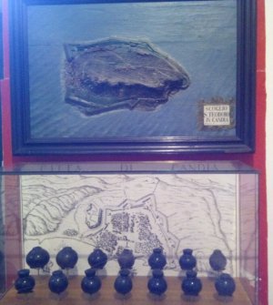
You may like this: map and 3d representation of one of their fortresses, made by the Republic of Venice, circa 1600AD. The blue spheres below are Murano glass bowls which were filled with burning pitch or black powder and thrown against the enemy during the battles, a few centuries before that Molotov guy :)
ven.jpg
 

dunedin

Well-known member
Joined
3 Feb 2004
Messages
13,986
Location
Boat (over winters in) the Clyde
Visit site
This discussion has gone - as many others - into a rather technical direction. While this is very interesting and might produce some good ideas for how to get on with the digital vehicle I wonder if there could be any other reason to go away from durable (see papyrus scrolls) forms of data storage to methods which are basicly self destructing, given some time.

When i look around amongst my friends, aquaintances whatever the relation might be, I see holiday-, family-, sportphotographs nearly only on screens, hardly ever printed any more. I guess in a not so far future our era will be known to the historians as the "time without picture documents".

What does it need to destroy a book? Fire, water, rot, mice ... all must attack the very book in it's storage location.

What does it take to eradicate the information on a digital data carrier? A magnetic field, a built_ and programmed in expiry date, a mad hacker or a not so mad one who sells me a programme to prevent his own destructive softwae from doing it's job?

Is it all about convenience, costs and ease of processing data or are we watching another gradual burning of Alexandria's library?

I also can build a three dimensional image from a two dimensional map/chart; I also like paper and the touch of it and so on. But this is personal, I learnt it at school, we were sent out to draw primitive maps by compass bearings and range estimation.
Just wondering....

I agree totally with @Sandy : Utter madness
BUT …. And it is a big BUT ….. the few people who still use paper charts are generally still using the ones they bought 5, 10, 20 years ago. How much have you spent on new paper charts in the past 12 months?

Imray made clear previously they wanted to maintain a paper chart service. The fact that they have, I assume very reluctantly, made this U-turn is presumably because the sales of paper charts are plummeting even faster than anticipated, and there is simply not enough income to cover the costs.

If the paper chart lovers all committed to paying a subscription of say £500 Pa then perhaps paper might continue.
Otherwise the only “utter madness” would be risking the rest of an important business by bleeding cash on paper charts that presumably too few are actually buying.
 

servus

Member
Joined
29 Jan 2024
Messages
49
Visit site
Even when we used to use magnetic storage magnets didn’t affect it. That was a decade ago though.
If you think photos and charts are durable try leaving one in the sun for a while.
I still have photographs from my childhood, my school years, university time aso. Obviously they were not left on the table on the verandah...
My intention was not to argue anything technical.
I observe patterns and wonder about repeating ones.
 

AntarcticPilot

Well-known member
Joined
4 May 2007
Messages
10,555
Location
Cambridge, UK
www.cooperandyau.co.uk
Even when we used to use magnetic storage magnets didn’t affect it. That was a decade ago though.
If you think photos and charts are durable try leaving one in the sun for a while.
Magnetic tapes (remember them?) were routinely erased using strong magnetic fields (not so strong in these days of rare earth magnets), and the magnetic domains were reckoned to decay in 5-10 years storage unless actively refreshed. I had a filing cabinet drawer of old tapes that were almost certainly unreadable, but which a) we had no equipment that could read them and b) I kept them for potential archival interest.

One place I worked held the tape archive of a well-known distributor of junk mail; we used to joke about walking past their racks with a strong magnet!

Spinning rust can only retain data long term if kept spinning and routinely refreshed. Of course we don't use that medium so much these days, but even non-volatile RAM is subject to slow decay as a result of random quantum events. Basically, all electronic storage depends on a continuing power supply for long term readability. The only exceptions I can think of are the purpose built discs sent out on the Voyager spacecraft.

Paper stored in dry, dark conditions can last for thousands of years with good legibility. Papyrus documents from 4000 years ago are still legible. Even sunlight faded documents can still be read - the ink has a different chemical signature to the paper, so infrared or UV illumination can usually make them readable. If that doesn't work, other more complex techniques will. For an extreme case, look at the recent feat of reading scrolls from Herculaneum that were converted to charcoal!
 

servus

Member
Joined
29 Jan 2024
Messages
49
Visit site
BUT …. And it is a big BUT ….. the few people who still use paper charts are generally still using the ones they bought 5, 10, 20 years ago. How much have you spent on new paper charts in the past 12 months?

Imray made clear previously they wanted to maintain a paper chart service. The fact that they have, I assume very reluctantly, made this U-turn is presumably because the sales of paper charts are plummeting even faster than anticipated, and there is simply not enough income to cover the costs.

If the paper chart lovers all committed to paying a subscription of say £500 Pa then perhaps paper might continue.
Otherwise the only “utter madness” would be risking the rest of an important business by bleeding cash on paper charts that presumably too few are actually buying.
It is of course cheap to state here but I do spend at least the value of 500 pounds per annum on charts, maps and similar items. I just like them - in paper.
I guess this is why I have a sailboat, which is also not the cheapest, most convenient, fastest etc way to get from A to B.
Call me a nutter, but I can sit over charts and maps for hours and try to form a picture in my head.
Here admittedly the satelite images are very good and valuable material.
 
Top