Mudisox
Well-Known Member
As my grand children remind me, I still live in an analogue way in the digital world.
Not a problem for me.
Not a problem for me.
Seriously, for the love of dog, you need to work on your signal to noise ratio.Its easy to say something - but a lot different to understand why something works ....
Putting A to B ... C to D ... easy ... but sorry - you illustrate what is wrong today ...
I know many programmers who can program just about anything ... but ask them how it works ... not a clue - so please stop the BS.
Good bye ..
You appear to be the living embodiment of this. I fully understand thanks, I don't need to reel off my entire CV to some nut on the Internet who has demonstrated time and again his lack of understanding of the subject.Its easy to say something - but a lot different to understand why something works
Seriously, for the love of dog, you need to work on your signal to noise ratio.
My intro to the forum was you telling me how to moor up an engineless boat in tide and chop. You’re like dog with a bone. I’ve got used to it now, and know there’s a lot of things you do know. I know nothing about drones, and only the barest minimum I need to know about my heading sensor, so I can make to judgement about the rights and wrongs of this thread drift. But, if you don’t mind me saying, the world in general, and this thread in particular, would be a kinder place if you could leave some others to their folly.I'm a nice guy but tolerate idiots badly ...
Always there to help in any way I can ...
My intro to the forum was you telling me how to moor up an engineless boat in tide and chop. You’re like dog with a bone. I’ve got used to it now, and know there’s a lot of things you do know. I know nothing about drones, and only the barest minimum I need to know about my heading sensor, so I can make to judgement about the rights and wrongs of this thread drift. But, if you don’t mind me saying, the world in general, and this thread in particular, would be a kinder place if you could leave some others to their folly.
Funniily enough i was looking at replacing my paper charts. I have 2 separate MFDs, 2 phones and I pad ply SWMBO also has phone and Ipad so from a back up perspective it felt fine.
BUT.
I'm not happy with the fact that the paper charts are now getting really old. The harbours and headlands etc won't have moved but for £50to pick up an Imray Folio feels sensible
That’s very similar to us. We carry a huge portfolio of paper charts. There’s no way I can correct them all. MFD has (corrected) up to date charting plus Navionics on two phones. Despite being brought up on paper charts pre Decca and GPS, I’m wondering why we carry so much paper.Despite my years of correcting charts on ships ... my record on my boats is opposite ! I actually collected cancelled charts of ships to add to my own inventory ...
On cruises - I like to have the Plotter running of course ... and then have a general chart at hand for any planning / changes we may decide ... the matter of how recent the chart is really doesn't bother me ...
I use Navionics App on Tablet and phone - so the latest updated is there for the actual nav ... my MFD has recent version of area .... therefore reasonably covered ....
I can fall back on my commercial package - but TBH - running the PC for it ... has no real advantage over above. It’s questionable whether I will continue to pay the high fees for it when comes due again.
Cost a lot to buy so too valuable to throw away!I’m wondering why we carry so much paper.

The Active Captain app' is free, which, given it can be used to create a second or third plotter, using the same charts as the plotter, i a bit of a surprise. Why create a free app' that does you out of plotter sales ? I have it installed on 2 104" Android tablets at the lower helm, either or both of which can mirror the plotter on the flybridge or act as stand alone plotters.There is one aspect that I noted .... as a professional Nav .. I would receive numerous NtM weeks on arrival in Port ... along with tracings ... I'll leave others to explain tracings ...
Basically weekly corrections to whole blocks of charts ....
With ECDIS - the corrections appeared to be less frequent ... every so often receive a CD ... stick it in the machine ... update etc.
With Yacht stuff - even less frequent ... until the Boating and Lakes App ... then I see updates each time I use it and click update.
My MFD Garmin ? again seems to lack frequency of updates ... and TBH ... the way it does it via "Active Captain" is IMHO a joke.

FYI "app" is a standalone word now, you don't need an apostrophe, but I admire the perseverance!app'
An app' is something for a 'phone.FYI "app" is a standalone word now, you don't need an apostrophe, but I admire the perseverance!
Apps can be used on phones, tablets or computers, none of which are abbreviations in 2023.An app' is something for a 'phone.
Apps can be used on phones, tablets or computers, none of which are abbreviations in 2023.
I think that this brings up a point that we seldom think about. Away from our home ground almost all our sailing is within marked channels or open water. I normally carry charts to the level necessary, but often this is grossly excessive to my actual needs. As a visitor to the Thames Estuary for example I would probably stay within buoyed channels, but where hazards seldom move one could get away with little information. I remember taking the channel in and out of Wangeroog without inshore charts and having no problem, and have met the odd sailor proceeding with only a road atlas, so in the end we each have to make our own judgement.Our primary navigation system is a waterproof chartplotter tablet running Orca (with OpenCPN as a backup). This device is powered by boat batteries, and gets GPS, AIS, etc from the N2K bus.
As a second layer we have a bunch of personal electronics that each have GPS and the Orca charts for current area downloaded to the device. We put some of these (and our handheld VHF which also has a GPS) to a Faraday cage whenever there is a thunderstorm.
If this layer also fails (or GPS goes out. In our Baltic cruising grounds Russians have occasionally spoofed or jammed it), we have the capability to go full analog with dead reckoning and a sextant (plus tables).
We don't carry full paper charts, but have a planning chart for our sea area (one for the Baltic, another for North Sea). We trust that we can hit a buoyed fairway with those and old-school navigation. Following that fairway should bring us to a harbour that's likely covered by one or another of our harbour guides.
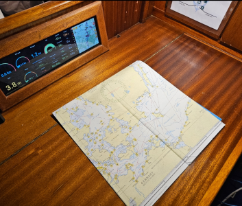
View attachment 168813
That depends hugely on where you go “away” to. In Celt land there are huge amount of rocky waters, but typically navigation marks are only placed where ferries or other large shipping runs. Otherwise it is necessary to study the charts and pilot books, and navigator beware.…….. Away from our home ground almost all our sailing is within marked channels or open water. …..