GPS anxiety

bergie

Active member
Joined
2 Feb 2021
Messages
142
lille-oe.de
That depends hugely on where you go “away” to. In Celt land there are huge amount of rocky waters, but typically navigation marks are only placed where ferries or other large shipping runs. Otherwise it is necessary to study the charts and pilot books, and navigator beware.
We also usually seek secluded nice anchorages among the rocky unbuoyed waters in the northern Baltic. But I think if our electrics were down and/or GPS was massively disrupted, I’d be ok going into a bigger, well-marked harbour to get things back online.
 

Roberto

Well-known member
Joined
20 Jul 2001
Messages
5,407
Location
Lorient/Paris
sybrancaleone.blogspot.com
Neither is graph paper!
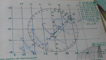
You don't need expensive charts for passage making, this is what I used pre GPS.

View attachment 168497

In very GPS days I used this, a laminated astro plotting sheet adapted to non-astro navigation, a way of drawing/erasing all sorts of lines, intervals, positions etc without spoiling a proper chart; not sure a plotter screen in the region 7-10" could hold all that info available at a single glance; pretty sure it can't, or by the time I digest the manual to obtain the same result I could well be already in port :)
It was a final 3-day run to the Azores, (very) bad weather expected around Horta, it helped figure out if a diversion to the southern islands was necessary.

plotsheet.jpg
 

Refueler

Well-known member
Joined
13 Sep 2008
Messages
20,754
Location
Far away from hooray henrys
Visit site
The Active Captain app' is free, which, given it can be used to create a second or third plotter, using the same charts as the plotter, i a bit of a surprise. Why create a free app' that does you out of plotter sales ? I have it installed on 2 104" Android tablets at the lower helm, either or both of which can mirror the plotter on the flybridge or act as stand alone plotters.

Generally speaking, it's a good app', but the update process is a real, clunky, piece of crap. One of my contacts at Garmin agrees with me on that one.
That was my point - the update process .....

I have no issue with mirroring etc. - its that log on ... log off ... system to update.
 

johnalison

Well-known member
Joined
14 Feb 2007
Messages
40,939
Location
Essex
Visit site
That depends hugely on where you go “away” to. In Celt land there are huge amount of rocky waters, but typically navigation marks are only placed where ferries or other large shipping runs. Otherwise it is necessary to study the charts and pilot books, and navigator beware.
I had a whimsical habit among the rocks off Sweden of referring to the buoys as having been put there to protect the rocks.
 

Refueler

Well-known member
Joined
13 Sep 2008
Messages
20,754
Location
Far away from hooray henrys
Visit site
Our primary navigation system is a waterproof chartplotter tablet running Orca (with OpenCPN as a backup). This device is powered by boat batteries, and gets GPS, AIS, etc from the N2K bus.

As a second layer we have a bunch of personal electronics that each have GPS and the Orca charts for current area downloaded to the device. We put some of these (and our handheld VHF which also has a GPS) to a Faraday cage whenever there is a thunderstorm.

If this layer also fails (or GPS goes out. In our Baltic cruising grounds Russians have occasionally spoofed or jammed it), we have the capability to go full analog with dead reckoning and a sextant (plus tables).

We don't carry full paper charts, but have a planning chart for our sea area (one for the Baltic, another for North Sea). We trust that we can hit a buoyed fairway with those and old-school navigation. Following that fairway should bring us to a harbour that's likely covered by one or another of our harbour guides.

In all the years I've been living and sailing here in Baltic ... Latvia, Estonia, Lithuania, Alands, Sweden ... I cannot remember any interference or Russian game with Glonass ....

Seriously interested to know examples from you ..
 

bergie

Active member
Joined
2 Feb 2021
Messages
142
lille-oe.de
In all the years I've been living and sailing here in Baltic ... Latvia, Estonia, Lithuania, Alands, Sweden ... I cannot remember any interference or Russian game with Glonass ....

Seriously interested to know examples from you ..
There was quite a bit of this stuff going on in 2022. Quick example:
Finland reports GPS disturbances in aircraft flying over Russia’s Kaliningrad

and this one from 2019:
https://www.reuters.com/article/us-norway-defence-russia-idUSKCN1QZ1WN/
 

bergie

Active member
Joined
2 Feb 2021
Messages
142
lille-oe.de
Being pedantic, two articles about GPS don’t address his question about Glonass
Fair point. And obviously my post he was replying to was talking about GPS disruption, not Glonass. Though I guess in a lot of places (including this thread), people use the term GPS to cover the various other GNSS constellations as well.

Though, if they’re interfering with GPS to mess with their neighbours, I’m not sure I’d trust the Glonass signal either.
 

lustyd

Well-known member
Joined
27 Jul 2010
Messages
12,479
Visit site
They do yes, but it’s important to distinguish in threads like this as a lot of people start ranting about selective availability etc. although broadly similar they are definitely distinct systems rather than just additional satellites. It’s quite interesting to look at how to use multiple systems simultaneously to get a fix and how it’s implemented in electronics. Most people assume the process is the same but with more signals.
 

AntarcticPilot

Well-known member
Joined
4 May 2007
Messages
10,576
Location
Cambridge, UK
www.cooperandyau.co.uk
They do yes, but it’s important to distinguish in threads like this as a lot of people start ranting about selective availability etc. although broadly similar they are definitely distinct systems rather than just additional satellites. It’s quite interesting to look at how to use multiple systems simultaneously to get a fix and how it’s implemented in electronics. Most people assume the process is the same but with more signals.
That matters for sophisticated techniques like spoofing or selective availability, but it is also worth noting that all GNSS signals are ridiculously weak, and crude noise jamming will obliterate all and any GNSS system quite easily. I understand that there are such systems available on the clandestine market to allow people like truck drivers to defeat tracking devices! And of course, the big noise generator in the sky can do a good job if it's in a bad mood. In the polar regions, GNSS is occasionally blanked by ionospheric disturbances caused by solar activity. Temperate and tropical regions are well protected by the Earth's magnetic field, but it would only take a solar mass ejection hitting the Earth full on and there would be no GNSS anywhere. Ionospheric disturbances can also cause inaccuracies by changing the Total Electron Content of the ionosphere, thus changing the time of flight of the signals. This is less of a problem these days with a full constellation and several systems and can be corrected for by dual frequency systems or by broadcast corrections, but I have attended presentations where researchers were using delays to GNSS signals to determine the TEC of the ionosphere! There are also situations where the ionospheric TEC changes rapidly, and this is less able to be corrected.

I accept that these are all either unlikely or can be corrected for, but it would be unwise to assume that these systems are completely proof against natural or malicious action. They aren't and that's why there are GNSS blackouts in the region of military exercises; the military knows GNSS may not be available in a war situation, so they practice operating in its absence. Incidentally, a high altuitude nuclear explosion would kill GNSS over a wide ares - see Starfish Prime
 
Last edited:

lustyd

Well-known member
Joined
27 Jul 2010
Messages
12,479
Visit site
I’m simply not willing to plan for a high altitude nuclear explosion in my cruising though. As you say it’s extremely unlikely, so unless there’s a good reason to plan for it most people don’t need to. It’s not like many boats are ever in a situation where they don’t know where they are anyway so in almost all cases can get to safety without navigation. Those that might be in a situation where they have no idea of position should plan accordingly.
 

AntarcticPilot

Well-known member
Joined
4 May 2007
Messages
10,576
Location
Cambridge, UK
www.cooperandyau.co.uk
I’m simply not willing to plan for a high altitude nuclear explosion in my cruising though. As you say it’s extremely unlikely, so unless there’s a good reason to plan for it most people don’t need to. It’s not like many boats are ever in a situation where they don’t know where they are anyway so in almost all cases can get to safety without navigation. Those that might be in a situation where they have no idea of position should plan accordingly.
But those sailing in high latitudes should be aware that GNSS may not be as reliable as in low latitudes. Again, the high degree of redundancy in today's systems lessens the problem, but it doesn't make it go away.

A pedantic point - it's actually high geomagnetic latitude, and as the geomagnetic pole is offset from the geographic pole, they aren't the same. Basically, anywhere in or poleward of the auroral zone should be aware of possible misbehaviour of GNSS.
 

lustyd

Well-known member
Joined
27 Jul 2010
Messages
12,479
Visit site
Speaking of magnetic poles, how many are truly on top of paper chart updates to account for variation that’s been very different than predicted? Magnetic north might quite different than the chart says.
How many have plans for a pole swap? Certainly an unlikely event, but the thread is all about unlikely events!
 

Chiara’s slave

Well-known member
Joined
14 Apr 2022
Messages
7,725
Location
Western Solent
Visit site
Speaking of magnetic poles, how many are truly on top of paper chart updates to account for variation that’s been very different than predicted? Magnetic north might quite different than the chart says.
How many have plans for a pole swap? Certainly an unlikely event, but the thread is all about unlikely events!
Would a pole swap not be predicted, or at any rate, be preceeded by a period of instability that raised the possibility? And assuming that it didn’t coincide with an outage of GNSS, for me it would just make reacting to wind shifts when racing harder. Cruising, my magnetic compass is a backup, not primary nav. We’d have to rely on GPS for our heading. The only reason I have a heading sensor is to improve wind data.
 

lustyd

Well-known member
Joined
27 Jul 2010
Messages
12,479
Visit site
Would a pole swap not be predicted, or at any rate, be preceeded by a period of instability that raised the possibility? And assuming that it didn’t coincide with an outage of GNSS, for me it would just make reacting to wind shifts when racing harder. Cruising, my magnetic compass is a backup, not primary nav. We’d have to rely on GPS for our heading. The only reason I have a heading sensor is to improve wind data.
I don’t think we know with any certainty what will happen. The poles are moving faster than predicted, making older charts or those without updates misleading to those relying on them for navigation. I just wanted to highlight that the old ways aren’t infallible
 

Chiara’s slave

Well-known member
Joined
14 Apr 2022
Messages
7,725
Location
Western Solent
Visit site
I don’t think we know with any certainty what will happen. The poles are moving faster than predicted, making older charts or those without updates misleading to those relying on them for navigation. I just wanted to highlight that the old ways aren’t infallible
Plenty of people failed at them, for sure. As for magnetic north corrections, I have never seen that done. I do have some 30 year old charts, but as they are stuck to the wall in the stairway to the loft room, it's not something that concerns me personally.
 

AntarcticPilot

Well-known member
Joined
4 May 2007
Messages
10,576
Location
Cambridge, UK
www.cooperandyau.co.uk
Speaking of magnetic poles, how many are truly on top of paper chart updates to account for variation that’s been very different than predicted? Magnetic north might quite different than the chart says.
How many have plans for a pole swap? Certainly an unlikely event, but the thread is all about unlikely events!
Compass corrections aren't much affected. There are TWO magnetic poles; one is the pole towards which compasses point; the other is the one where the magnetic field lines are vertical. They don't coincide because the Earth's magnetic field is complicated (it isn't a simple dipole field like that of a bar magnet). The latter is the one that is moving quickly; the former (which is what matters when it comes to deviation and variation) is not. So it isn't a problem.

As far as pole reversals go, we're well overdue for one. But as the change will take at least a lifetime, the rate of change will be slow enough to be manageable. We know that the field is never zero; if it were, there would be routine mass extinctions every few hundred thousand years! But as the last one happened before our ancestors learned to bang rocks together, we don't have any direct knowledge. We do have some indications of timescales from ice cores.
 

lustyd

Well-known member
Joined
27 Jul 2010
Messages
12,479
Visit site
Quite a lot of sources online suggesting it is a problem for navigation. | EarthSky

As far as the poles swapping, "we currently think" should probably be added to what you said. Even if it does take a lifetime to shift, that means potentially compass based navigation is useless for a lifetime!
 

lustyd

Well-known member
Joined
27 Jul 2010
Messages
12,479
Visit site
That confirms my thinking, thanks AP. We are not going to just wake up and find the world upside down.
But that is even worse from a navigation perspective. If tomorrow north became south, we could just swap everything over. If it takes many years it could be chaos, and we don't know for sure whether the change will be predictable since we've never seen it happening before!
 
Top