You are using an out of date browser. It may not display this or other websites correctly.
You should upgrade or use an alternative browser.
You should upgrade or use an alternative browser.
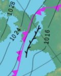
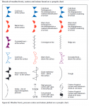
Synoptic chart - what does trough line with barbs mean
- Thread starter tudorsailor
- Start date
Driftingby
Member
STOL71
Member
To me, it looks like an iron curtain being lowered between the UK and Europe.
alan_d
Well-known member
So it's a convergence line. What's that?
WoodyP
Well-known member
Convergence linesSo it's a convergence line. What's that?
KompetentKrew
Well-known member
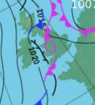
In case anyone else is interested in how the convergence fits into the larger picture:


boomerangben
Well-known member
I thought it a forecast of seaweed on the surface
tudorsailor
Well-known member
Thanks for pointing me in the right direction
factsheet_11-interpreting-weather-charts.pdf (metoffice.gov.uk)
TS
factsheet_11-interpreting-weather-charts.pdf (metoffice.gov.uk)
TS
Sandy
Well-known member
You need to build a proper weather station.I thought it a forecast of seaweed on the surface
Small rock on a bit of string with wind scale drawn on a board.
Glass jar containing seaweed to indicate how wet it is.
Bodach na mara
Well-known member
Used to be called an occluded front back around 1960
Buck Turgidson
Well-known member
nope. plenty of occluded fronts on the same chart.Used to be called an occluded front back around 1960
boomerangben
Well-known member
?You need to build a proper weather station.
Small rock on a bit of string with wind scale drawn on a board.
Glass jar containing seaweed to indicate how wet it is.
Living in the outer Hebrides, there’s no need for stone on string - it needs a chain, besides it would always be horizontal and wet. If it’s really windy, the sea weed is in the garden
capnsensible
Well-known member
And if you can't see the stone it's foggy.?
Living in the outer Hebrides, there’s no need for stone on string - it needs a chain, besides it would always be horizontal and wet. If it’s really windy, the sea weed is in the garden
ronsurf
Well-known member
A convergence is when two air masses are forced together, forcing the air upwards. This typically results in very heavy localised rain.
An example is the Boscastle event. Air flow over the land slows and is deviated towards the centre of the depression. This then meets the air over the sea which has not deviated. The two meet and have nowhere to go but upwards, creating cloud and often heavy rain.
This is different to an occluded front where one air mass is pushed under a different air mass. A convergence is more local and occurs within the same air mass.
tudorsailor
Well-known member
Other threads that may be of interest
- Replies
- 6
- Views
- 255
Members online
- RunAgroundHard
- Whaup367
- Fr J Hackett
- Jameskb
- Greg2
- DoubleEnder
- Ribtecer
- TobPhil
- Akers_like
- Hacker
- xcw
- DavidJ
- PeteCooper
- ghostlymoron2
- jon711
- MOBY2
- macca499
- Hot Property
- mjcrum302
- wonkywinch
- mjcoon
- Mark AM
- Tinto
- myquest
- barryhall
- AndyPoole
- Chiara’s slave
- Alicatt
- mrming
- Alvin YArk
- Cheery
- davidej
- Bouba
- gavin400
- plumbob
- Skylark
- Richard.C
- scottie
- Martin_J
- Minerva
- Openelectron
- DownWest
- Jack Haines
- Cymrogwyllt
- thalassa
- kaptainkrunchie
- tetleys
- Peterlewis321
- SeaLimpet
- starfire
Total: 883 (members: 69, guests: 814)


