Old dog new tricks

Geoff A

Member
Joined
15 Jan 2023
Messages
91
Visit site
If this has been covered before my apologies. I have always navigated using charts, its about time I got up to date. After a long lay off from sailing I have decided to get another sailing boat, the one I am looking at has a chart plotter this one. I will be viewing the boat in the next few days. weather I buy the boat or not does not come into it, its me about me getting my backside into gear.
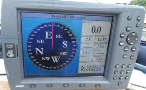
151393969gallery_wm.jpg
I think it is a Garmin 2010c, if I am wrong what make and model is it? I have used a chart plotter a couple of times in the past but a long time ago. I do not know if there are any charts loaded on to this plotter, if there is i do not know how old they would be. What I need to know is how to down load the charts for this plotter (would it be on to a SD card)? I am thinking of Navionics as it seems to be one of the most popular ones. I need someone to walk me through the process, I know I can down load a trial for a couple of weeks, that would be plenty of time for me to get the boat back to my home marina, but would you trust the free trial. I also have a new phone a Samsung Galaxy A15 5G that I think I would run Navionics as a back up. I have plenty of old charts to get me home, they are a bit old, only about twenty years out of date. The land does not change much, with No1 eyeball navigation and a reliable depth sounder. ? ;) I would have them with me. Boat south coast me east coast. So you knowledgeable lot educate me.
 

jwilson

Well-known member
Joined
22 Jul 2006
Messages
6,107
Visit site
I think this is approaching 20 years old, so would not be surprised if chart cartridges or updates were no longer available. Garmin support seems to think anything much over 5 years old is not serviceable. If it works and if there are charts loaded, the rocky bits won't have changed that much. I'd buy a new paper chart and use a phone or tablet with up to date charting.
 

KompetentKrew

Well-known member
Joined
27 May 2018
Messages
2,438
Visit site
You're not into chartplotters then I would just ignore this one for the purposes of your inspection.

Compared to the money you'll be spending to buy the boat, and the costs of fixing any other potential problems, the value of this chartplotter is negligible. So concentrate on finding any other faults with the boat and don't worry about this chartplotter. I believe you're correct about the model - I'm surprised to find that such an old model still commands prices as high as £300 or £400 on eBay.

Assuming the screen comes on then it probably works, if any charts are supplied then they'll be out of date (but, as you say, the rocks won't have moved much).

Personally I dislike Navonics on phone or tablet - in the cockpit I would rather have a chartplotter because it will be waterproof and daylight viewable; it will be properly secured and can't be dropped over the side or broken by sitting on it. But I appreciate your budgeting may differ.
 
Last edited:

nevis768

Active member
Joined
18 Jul 2023
Messages
244
Visit site
You're not into chartplotters then I would just ignore this one for the purposes of your inspection.

Compared to the money you'll be spending to buy the boat, and the costs of fixing any other potential problems, the value of this chartplotter is negligible. So concentrate on finding any other faults with the boat and don't worry about this chartplotter. I believe you're correct about the model - I'm surprised to find that such an old model still commands prices as high as £300 or £400 on eBay.

Assuming the screen comes on then it probably works, if any charts are supplied then they'll be out of date (but, as you say, the rocks won't have moved much).

Personally I dislike Navonics on phone or tablet - in the cockpit I would rather have a chartplotter because it will be waterproof daylight viewable; it will be properly secured and can't be dropped over the side or broken by sitting on it. But I appreciate your budgeting may differ.
I use Navionics on my Phone, I don't bother with my plotter much because I find Navionics much better, my phone is waterproof, 15 Pro max, and it's on a lanyard. I turn the screen brightness up to read it if it is sunny, although with the boat in Scotland I think it is a few weeks since I did that.
I think the plotter is a few years old, a Raymarine, next to useless, not touch screen.
I also use a chart in conjunction with the phone.
 

Sandy

Well-known member
Joined
31 Aug 2011
Messages
21,780
Location
On the Celtic Fringe
duckduckgo.com
Nothing wrong with charts! These new fangled chart plotters cause alarm and distress. As for these young whip-pa snappers with their heads in their phones all the time they have no 'situational awareness' as our American friends call it, don't have a clue where they are is what I say.

Seriously, if you are going to look at chart plotters get one that is NMEA 2000 compliant as you will be able to plug all sorts of stuff in and it just works - no fussy soldering of blue and yellow wires.

p.s. you might find a whole bunch of wind farms on your 20 year old charts - they get in the way but have made navigation so much easier. Follow that line of turbines then turn to a heading of 035 °T and you will spot the next wind farm after 2NM.
 

onesea

Well-known member
Joined
28 Oct 2011
Messages
3,828
Location
Solent based..
Visit site
As other have said use your charts, the plotter for position and. guidance and Navionics on your phone and tablet you can put it on 3 devices as I recall.

Personally as I like charts and as has been recommended on here I also have MemoryMap better for traditional charts not so good on features.

When you look into plotters you can get allot of kit for 2k. AIS Class B Depth sounder, chart plotter NMEA 2000 & 183.
 

Refueler

Well-known member
Joined
13 Sep 2008
Messages
20,428
Location
Far away from hooray henrys
Visit site
Blimey ... I read replies and think some have lost the plot !! (forgive the joke !!)

As I understand it - the 2010C plotter is not a factor to stop purchase of the boat - OP is asking advice on its use and whether still viable.

Simple answer is to look at the manual and also online Garmin site to see about compatibility ... Garmin are ar*****es when it comes to compatibility - they insist on taking a perfectly good product such as Navionics and altering it so you need Garmin version to run on Garmin gear ...

But lets see about this 2010C ... its old - but there is no reason why it should not function well ...

GPSMAP® 2010/2010C | Garmin Support

It uses BlueChart or Mapsource data cards ... not Navionics

Lets look at Garmins List of compatibles ....

"
Cartography – The 2010C features 2 built-in Micro card expansion slots for using Garmin’s BlueChart™ cartography. These charts provide integrated maps for a much smoother presentation.

Note: The 2010C uses BlueChart™ no base map. The 2210 uses BlueChart® g2 and comes preloaded with a basemap."

___________________________________________________

Ok - so we now know what cartography it uses - not Navionics. I would be inclined to look on eBay for a recent expired chart card to suit ... or you could approach a Garmin Dealer to buy a current card - if still available - but it will be expensive.
Overall if the unit works - why change it ?

To have latest charting in hand ... you can have Garmins Navionics on your smartphone or tablet for a lot less cost than any chart card for plotter ... and it includes updates. You can transfer routes / waypoints from the phone to the plotter etc.
 

Seasick Steve

New member
Joined
15 Jul 2013
Messages
5
Location
Liverpool
Visit site
If you want a plotter, I'd recommend a Tough Tab from visitmyharbour.com
It runs Marine Navigator with Admiralty raster charts, can be used as a tablet and is resilient and waterproof.
 

Refueler

Well-known member
Joined
13 Sep 2008
Messages
20,428
Location
Far away from hooray henrys
Visit site
If you want a plotter, I'd recommend a Tough Tab from visitmyharbour.com
It runs Marine Navigator with Admiralty raster charts, can be used as a tablet and is resilient and waterproof.

With great respect - I have never seen the point of such setup ... especially now that Navionics is available on a phone / tablet ...

You can buy a Toughbook which will survive most use outside if you really must have weatherproof for budget money ... load up Navionics and be happy.
Vector format - so zooming in still keeps readable labels etc - unlike raster that pixellates out.
 

Dellquay13

Well-known member
Joined
19 Feb 2021
Messages
972
Location
Boat at Milford Haven, Home in Chesterfield
Visit site
Raster charts are for dinosaurs.
There I was stood at the back of a wind powered boat, struggling with a wooden stick akin to a steering oar, in the lashing wind and rain, and you have just confirmed to me that in spite of Man’s technological advances, the big gaping chasm between me and a Viking mariner is in fact Goretex
 

vas

Well-known member
Joined
21 Jun 2011
Messages
8,082
Location
Volos-Athens
Visit site
trying to also reply to OP...

probably works (screen fires up it seems)
GPS antenna (separate item fitted somewhere on the boat) is probably working (if the pic posted is the one from the boat as it shows a fix). However it may still need a gps antenna change to show the right date for tides and such...
HOWEVER, the card with the map on it, is not the bog standard SDCARD you see on newer plotters but a fancy oblong thing that needs a special hardware reader/writer to upload a new(er) map to it.
Have done so 7-8yrs ago, wasn't easy, wasn't fun, not looking fwrd to doing it again.
So, if the map on it is recent (really cannot be unless someone spend lots of time picking a Bluechart from newer plotters and packaging it into this somehow) it's fine, else you just look at the rocks and coastline :)
wouldn't invest money on it, just replace it with a NMEA2000 device and sell that on on ebay!

V.
 

Geoff A

Member
Joined
15 Jan 2023
Messages
91
Visit site
I know the difference between Gnomonic projection and Mercator projection charts. I am reasonably confident if push came to shove I could just about get away using a sextant. I will admit I had to look up the difference between Raster and Vector charts. I like being a dinosaur at least being one it does not tie my head in knots trying to deal with all the new to me techometry:). Thank you every one between you all you have helped me a lot I will include YouTube as well as it is a good teaching tool. If I buy this boat I will be using A bit of everything mentioned in the replies. I wish you all a good boating summer.
 

Refueler

Well-known member
Joined
13 Sep 2008
Messages
20,428
Location
Far away from hooray henrys
Visit site
trying to also reply to OP...

probably works (screen fires up it seems)
GPS antenna (separate item fitted somewhere on the boat) is probably working (if the pic posted is the one from the boat as it shows a fix). However it may still need a gps antenna change to show the right date for tides and such...
HOWEVER, the card with the map on it, is not the bog standard SDCARD you see on newer plotters but a fancy oblong thing that needs a special hardware reader/writer to upload a new(er) map to it.
Have done so 7-8yrs ago, wasn't easy, wasn't fun, not looking fwrd to doing it again.
So, if the map on it is recent (really cannot be unless someone spend lots of time picking a Bluechart from newer plotters and packaging it into this somehow) it's fine, else you just look at the rocks and coastline :)
wouldn't invest money on it, just replace it with a NMEA2000 device and sell that on on ebay!

V.

We shall agree to differ .....

I think you are making a lot of assumptions as well as possibles that most likely are not there.
 

vas

Well-known member
Joined
21 Jun 2011
Messages
8,082
Location
Volos-Athens
Visit site
We shall agree to differ .....

I think you are making a lot of assumptions as well as possibles that most likely are not there.
np, was just trying to add some (imho) sensible info on this kit which is what the OP asked for.
if that's the kit on the boat he's viewing, lets agree that it gets a fix and works.
The rest is really history and should be viewed as such :)
 
Last edited:

Refueler

Well-known member
Joined
13 Sep 2008
Messages
20,428
Location
Far away from hooray henrys
Visit site
np, was just trying to add some (imho) sensible info on this kit which is what the OP asked for.
if that's the kit on the boat he's viewing, lets agree that it gets a fix and works.
The rest is really history and should be viewed as such :)

No worries .. was not intending to be rude or anything ...

I have an old Lowrance that is possibly older than OP's Garmin ... still works ... some have asked why I still keep it and use it ... why not ? OK .. my later 38ft has the Garmin MFD ... and I also use my ONWA on there because of the AIS built in ... but that old Lowrance still has a place ... on my 25 or latest Mobo I bought ... haven't quite decided which yet.
 

KompetentKrew

Well-known member
Joined
27 May 2018
Messages
2,438
Visit site
Vector format - so zooming in still keeps readable labels etc - unlike raster that pixellates out.
This is a benefit of raster charts - it is a feature and not a bug. When you can see the pixels you know that you're viewing the wrong scale of chart, and you should switch to a larger scale chart.

OpenCPN can automatically change to a more suitable sale of raster chart for you, it works somewhat well, or you can change manually.

What you say is actually a disadvantage of vector charts - if you zoom in too far using a vector chart then there is nothing to indicate the absent details, you just get a smooth curve and no indicators of rocks, shallows, buoys etc.

Anyone can see this for themselves using NOAA's enc charts of North America - both US2EC02M and US5NC1LP cover the New River at Jacksonville. NC, but the first covers Cape Hatteras to Straits of Florida at 1:1,200,000 scale and the other is at 1:12,000 scale. You can load these up on your PC and the whole of the US east coast is covered at 3 different scales.

There seems to be an attitude on this forum that vector charts are "obviously" better than raster charts, like vector sag files are "obviously" better than jpegs or goes. You only have to look for yourself and see that this is not always the case.
 
Top