RIN / MAIB "digital navigation" webinar Nov 16th

requiem

Active member
Joined
20 Mar 2019
Messages
254
Visit site
Another problem is the requirements to only use official data with known accuracy. That means that all the useful info that is added from harbour masters, marinas etc. that is added to paper charts and commercial software cannot be added to this.

If it's good enough to add onto paper charts, it should be good enough to add onto ENCs. After all, they are supposed to have legal status as paper equivalents.

In any case, "official data with known accuracy" is precisely that: the level of accuracy may be known (or assigned), but that level need not be "high".
 

Marsali_1

Member
Joined
8 Jan 2021
Messages
63
Visit site
You’ve missed the point entirely. Driving law for the most part is sensible. This is more like the driving while using a phone law. Utterly pointless. Or if they legislate that cars can’t be blue of green in case you mistake them for sky or grass.
Oh, I got your point. Rules, regulations and standards are fine as long as you are not disadvantaged by them or that you deem them to be OK. Since you can drive a car without having an accident while using your phone means that there should be no regulation of the other idiots on the road because of it impinging on your rights.
 
Last edited:

lustyd

Well-known member
Joined
27 Jul 2010
Messages
12,504
Visit site
Oh, I got your point. Rules, regulations and standards are fine as long as you are not disadvantaged by them or that you deem them to be OK. Since you can drive a car without having an accident while using your phone means that there should be no regulation of the other idiots on the road because of it impinging on your rights.
No you didn’t get the point at all. There is no advantage to things like colour calibration of screens on a boat. None at all. If the weather changes that calibration is lost. If it gets dark that calibration is lost. Sunset? Gone.
There is significant science to suggest that standardising a colour palette is bad. User customisation is better since users can set things up for best viewing for them.
Regulating these things makes the solution worse, not better. The only reason these things are in there is the committee led approach and empire building regulators. I have no issue with sensible standardisation and obviously some standards are necessary in commercial solutions to ensure the solutions are effective. The fewer the better though, otherwise costs needlessly escalate and innovation is stifled. Sometimes overzealous regs are dangerous, the colour palette might mean some folk are unable to see dangers due to sight issues.
 

Sandy

Well-known member
Joined
31 Aug 2011
Messages
21,909
Location
On the Celtic Fringe
duckduckgo.com
...the paper charts that are down to one provider, which is desperate to stop? the paper charts that are getting harder to get? In practice I don't think sea schools are going to get out of this one.
Can you name that provider?

After both the HO and Imray letting everybody know they are ceasing the production of paper charts I have, reluctantly purchased a tablet from Visit My Harbour, but still want to use paper charts.

One positive benefit is at least I can see where we are on a delivery without prizing the skippers tablet out of their frozen hands while they sleep.
 

justanothersailboat

Well-known member
Joined
2 Aug 2021
Messages
546
Visit site
I thought the Admiralty had stretched out the end date on paper charts? Last I read, they'd u-turned on stopping them next year, so there will be a few more years. That's one provider, desperate to stop. I assume they may yet u-turn the u-turn.
 

st599

Well-known member
Joined
9 Jan 2006
Messages
7,570
Visit site
I thought the Admiralty had stretched out the end date on paper charts? Last I read, they'd u-turned on stopping them next year, so there will be a few more years. That's one provider, desperate to stop. I assume they may yet u-turn the u-turn.
They didn't U-turn, just delayed implementation until there's a For Navigation digital solution available. (All current plotters are Not For Navigation).
They are no longer producing small craft folios and are print on demand only.
Imray are exiting the market this year.
 

st599

Well-known member
Joined
9 Jan 2006
Messages
7,570
Visit site
If it's good enough to add onto paper charts, it should be good enough to add onto ENCs. After all, they are supposed to have legal status as paper equivalents.

In any case, "official data with known accuracy" is precisely that: the level of accuracy may be known (or assigned), but that level need not be "high".
I think the issue is that the international standard for ENCs don't allow it. If the chart contains such information, the plotter has to display a "Not for Navigation" warning.
 

justanothersailboat

Well-known member
Joined
2 Aug 2021
Messages
546
Visit site
They didn't U-turn, just delayed implementation until there's a For Navigation digital solution available. (All current plotters are Not For Navigation).
They are no longer producing small craft folios and are print on demand only.
Imray are exiting the market this year.
That IS u-turning on cutting them off. They say til 2030 now, but I wouldn't bet money on it. Presumably that extension contributed to tipping the balance for whether it was worth Imray continuing.

Personally, I'm going on an Imray pack binge while I can still get them.
 

mrming

Well-known member
Joined
28 Jul 2012
Messages
1,665
Location
immaculateyachts on Instagram
instagram.com
An adjacent point to this is the quality of User Experience and User Interface on the “not for navigation” leisure plotters.

Drawing lines and annotating charts is practical on a PC with a decent size screen and a pointing device, or a large iPad with the Apple Pencil.

Many current leisure MFDs (including my own) are touch screen only. Some also include some hardware buttons and dials, but those controls are not designed for drawing or annotating.

I draw on a computer (with a graphics tablet) as part of my job so I have decades of experience of this. Have you ever tried to draw or annotate on a small touchscreen? What if it’s now moving around in a seaway?

The current crop of leisure MFDs are designed for convenient route and waypoint based navigation using GPS and an electronic compass. They’re like this because it’s what the market wants, and buys.

If regulators insist companies like Raymarine, Garmin and Simrad implement drawing and annotating features, do you think they’ll change the product’s design to make those features easy to use? My guess is they’ll implement the fastest version that meets the letter of the law, and it will not be easy to use.

This is the reality of regulation and low volume tech products. The output will please no one. Sad, but inevitable.
 
Last edited:

lustyd

Well-known member
Joined
27 Jul 2010
Messages
12,504
Visit site
My guess is they’ll implement the fastest version that meets the letter of the law, and it will not be easy to use
For almost all customers that's perfectly fine. If there was demand to navigate any other way the features would already be there. I imagine the number of people who would actually genuinely bother placing marks will be in the low hundreds, if that, even if the products supported it and it were easy to use. Most people are never in a scenario where marks would be needed and the vast majority never leave local waters so could happily turn the plotter off and just look out of the window.
 

requiem

Active member
Joined
20 Mar 2019
Messages
254
Visit site
Have you ever tried to draw or annotate on a small touchscreen? What if it’s now moving around in a seaway?
Yep, on both phone and iPad, no Apple Pencil needed. Certainly simpler than doing it on paper, and more error tolerant since I can drag a misplaced line into the correct position. This isn't free-hand drawing, nor should it be.

Most detailed work would be done as part of planning before leaving the dock. In terms of MFDs, many deal with the "can't see under the finger" problem by offsetting the cursor so that you can drag it to precisely the desired spot. The items this spec calls for are features I currently make use of, and my phone's screen is far smaller than the minimum display size.
 

RunAgroundHard

Well-known member
Joined
20 Aug 2022
Messages
2,352
Visit site
Yep, on both phone and iPad, no Apple Pencil needed. Certainly simpler than doing it on paper, and more error tolerant since I can drag a misplaced line into the correct position. This isn't free-hand drawing, nor should it be.

Most detailed work would be done as part of planning before leaving the dock. In terms of MFDs, many deal with the "can't see under the finger" problem by offsetting the cursor so that you can drag it to precisely the desired spot. The items this spec calls for are features I currently make use of, and my phone's screen is far smaller than the minimum display size.

Which App and device are you doing this with? Also can you elaborate, for example, have you plotted more than one position line simultaneously based on hand bearings readings on the screen of your App.

For example, On Garmin Boating (ex Navionics), running on iPhone 14 Pro, iOS 18.1.1, I can create 1 x pair of "pins" and use that as a position line (bearing and distance between the two is shown), but as far as I can tell, I can only do this once. I can place any number of "markers" but can't get the App to tell me the bearing between each. Even using "Rout" function in manual mode, as a position line, can't be used as the line on the screen doesn't show course. It does show start and end Lat and Long and hence angle can be calculated. At least in this case, with my current understanding, Garmin Boating can't be used to establish any sort of position using its built in functionality, even as a round about way of obtaining a position. Happy to be corrected as my understanding of functionality may be flawed or incomplete.

Memory Map, on my MacBook Air is similar, I can plot a rout in manual mode and a single line does sow bearing. I have yet to find how to plot a second rout that crosses the first, to simulate position lines. Same with adding "marks" they are just points of information on the chart, you can't get two marks to join up.

So far, only Angel Nav allows this sort of functionality, but it runs Raster charts, so no compliant.
 
Last edited:

requiem

Active member
Joined
20 Mar 2019
Messages
254
Visit site
Which App and device are you doing this with? Also can you elaborate, for example, have you plotted more than one position line simultaneously based on hand bearings readings on the screen of your App.
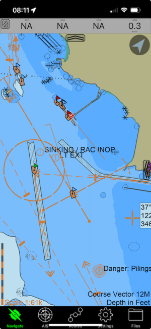
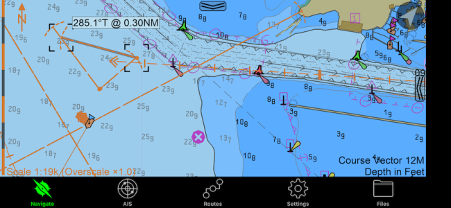
SEAiq, on iPhone, iPad, and Macbook. (Unfortunately not so practical if your country charges for charts.)

Unlimited EBLs and VRMs, and can also attach them to own-ship or AIS targets if desired. I just quickly added a few here to illustrate. I set course vectors to 12 minutes.

1736959091786.png
1736959156297.png
 
Last edited:
Top