RIN / MAIB "digital navigation" webinar Nov 16th

requiem

Active member
Joined
20 Mar 2019
Messages
254
Visit site
One clear issue was excessive warning messages on ECDIS - eg about 500 on one shortish route in Scotland. Hence tendency simply to rapid click accept on all of them without taking time to spot the really important ones buried within the dross - like your route will make you crash into a large rocky island!

I'm curious how much was due to not setting the route parameters correctly for the area (e.g. smaller XTE) vs it simply being too tight a route. The route checking feature feels a bit like auto-routing: an attempt at a helpful feature that in the end will still require manual review, yet it also discourages that manual checking.

Unfortunately that’s how we end up with inappropriate systems since committees will work in exactly that way rather than asking what leisure sailors actually need. DSC is a great example of how this has gone wrong in the past, even something as simple and reasonable as reprogramming the mmsi is impossible, let alone tuning out the noise of alerts.

My sense is the marine industry is still a few decades behind in terms of accounting for human factors (alarm fatigue, etc). I have mixed thoughts on the MMSI; it might be convenient to reprogram it to e.g. "US Warship" when cruising certain areas of the world, but it might be messier with random people setting theirs to "Maersk Colossus" in busy areas. I do lean towards the "let people change it" view.

Speaking of what leisure sailors might need, I do have an example on the charting side. On another forum there's been discussion of charts for Newfoundland, where the only detailed charts are a bit out of sync with land, (as well as the current century). Might drop it in the other thread... Edit: guess this is the other thread I had in mind!
 
Last edited:

requiem

Active member
Joined
20 Mar 2019
Messages
254
Visit site
Ok, here goes... on the topic of why being able to plot positions separate from GNSS data might be beneficial.

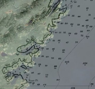
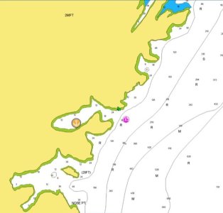
A member of another forum has been looking for detailed charts of Newfoundland, something that would match the very detailed data that Navionics had and they couldn't find elsewhere. I have a good guess as to why, but I'll share this bit from some screenshots they shared, a satellite overlay on the raster chart layer and chart of the area from the aforementioned app. I should point out that some other 3rd party chart sources use this as well. There is not yet official large-scale chart coverage for this area, so some apps don't show this level of detail at all. (Bonus points for guessing the survey year.)

Needless to say, this is a case where if using those charts I'd much prefer to plot fixes manually, saving GNSS coordinates for a Mayday or other need. I've also run across other charts for remote areas with explicit warnings to not use GNSS data for position plotting.

old-charts.jpgold-chart-navionics.jpg
 

lustyd

Well-known member
Joined
27 Jul 2010
Messages
12,504
Visit site
it might be convenient to reprogram it to e.g. "US Warship" when cruising certain areas of the world, but it might be messier with random people setting theirs to "Maersk Colossus" in busy areas. I do lean towards the "let people change it" view.
What’s funny is that we can do that now. What we can’t do is change it to something sensible afterwards. The industry lacks a sense of proportion.
 

lustyd

Well-known member
Joined
27 Jul 2010
Messages
12,504
Visit site
Needless to say, this is a case where if using those charts I'd much prefer to plot fixes manually, saving GNSS coordinates for a Mayday
Two things. Firstly that simply looks like the wrong datum is in use which is an easy fix. Secondly you don’t have to be able to draw lines to avoid hitting the land.

First and foremost the plotter interface for leisure must be easy and intuitive to use. That the charts are bad is a separate issue which does need fixing, but we absolutely must not make the plotter more difficult to use or clutter the interface to try to fix bad charts. It doesn’t fix the bad charts, just makes the plotter worse.

Fixing charts can be automated. We know from satellite imagery that they are not correct and it’s relatively trivial to sort out using AI techniques. The OS use these techniques in mapping the UK.
 

Alicatt

Well-known member
Joined
6 Nov 2017
Messages
4,957
Location
Eating in Eksel or Ice Cold in Alex
Visit site
Unfortunately that’s how we end up with inappropriate systems since committees will work in exactly that way rather than asking what leisure sailors actually need. DSC is a great example of how this has gone wrong in the past, even something as simple and reasonable as reprogramming the mmsi is impossible, let alone tuning out the noise of alerts.
Two things. Firstly that simply looks like the wrong datum is in use which is an easy fix. Secondly you don’t have to be able to draw lines to avoid hitting the land.

First and foremost the plotter interface for leisure must be easy and intuitive to use. That the charts are bad is a separate issue which does need fixing, but we absolutely must not make the plotter more difficult to use or clutter the interface to try to fix bad charts. It doesn’t fix the bad charts, just makes the plotter worse.

Fixing charts can be automated. We know from satellite imagery that they are not correct and it’s relatively trivial to sort out using AI techniques. The OS use these techniques in mapping the UK.
At the end of the year VDES compliance is going to be compulsory for those of us on the European waterways, that is being touted as a way of updating charts etc. for commercial shipping.

I have been trying to find out what is compliant and what is not, UK dealers I have talked to didn't know about it and have had to find out and get back to me, Icom said that new stock would be compliant and that firmware updates would be coming for older radios, Standard Horizon have still not answered my enquiry, however friends here have had to go off to get their SH handhelds and fixed radios reprogrammed by the dealer, while in the USofA you can download and update the firmware in the radio yourselves.

Sooo, if I connect my VHF to the plotter/MFD will it automagically update the chart, and how does it know which proprietary chart and chart plotter I'm using?
How long is it going to take to update a 32GB chart suite on the memory card in my plotter over VHF.
 

requiem

Active member
Joined
20 Mar 2019
Messages
254
Visit site
Two things. Firstly that simply looks like the wrong datum is in use which is an easy fix. Secondly you don’t have to be able to draw lines to avoid hitting the land.

In this case, the chart appears to claim NAD83 (i.e. functionally equivalent to WGS84). But the survey is from an older Admiralty chart from 1897. The offsets don't appear to be a simple X,Y translation issue, but as you mentioned AI should be able to assist in correcting the charts. But, it can take years, and there's plenty of coastline on the planet with similar issues.

Yes, there are a few things you could do: grab satellite imagery, use radar, etc. But if we're talking chartwork and replacing paper, then it's reasonable to expect that your paper replacement is able to handle taking a running fix on a light ashore. And it's also reasonable that your paper replacement should have the equivalent of a source diagram so you know how much to (dis)trust it.

First and foremost the plotter interface for leisure must be easy and intuitive to use. That the charts are bad is a separate issue which does need fixing, but we absolutely must not make the plotter more difficult to use or clutter the interface to try to fix bad charts. It doesn’t fix the bad charts, just makes the plotter worse.

Something on the scale of ECDIS or even OpenCPN is likely overkill, but adding some basic functionality doesn't make it more difficult to use. I'd argue that people using waypoints as a generic stand-in for all sorts of features that aren't waypoints at all makes for a far more cluttered and confusing interface.
 

lustyd

Well-known member
Joined
27 Jul 2010
Messages
12,504
Visit site
But then if it’s not a simple translation issue that suggests the paper chart is wrong too in which case taking bearings just adds confidence to incorrect answers.
 

dunedin

Well-known member
Joined
3 Feb 2004
Messages
14,072
Location
Boat (over winters in) the Clyde
Visit site

requiem

Active member
Joined
20 Mar 2019
Messages
254
Visit site
I've unfortunately missed both sessions, but the first one has since appeared here on YouTube. Of the issues discussed, I'm not sure I'd wave them off as being ECDIS-specific. The basics of passage planning (does my route pass through a rock? do I have the most current charts? how trustworthy are the chart data? what are the tides?) are fairly universal.

Features generally unique to ECDIS would be the route-checking and alarms, which as mentioned can easily contribute to "alarm fatigue", lessening their value.
 

Sandy

Well-known member
Joined
31 Aug 2011
Messages
21,909
Location
On the Celtic Fringe
duckduckgo.com

jlavery

Well-known member
Joined
25 Oct 2020
Messages
649
Visit site
Having watched the second session I resisted the temptation to slit my wrists. Why the RIN felt the need to publish a pre, pre, pre meeting on YouTube is beyond me. I've had better rambling discussions with the office cat.
Ah, so sounds like not worth watching!
 

lustyd

Well-known member
Joined
27 Jul 2010
Messages
12,504
Visit site
One section was discussing the need for a printed symbol guide from electronic chart vendors. This is the wrong group of people to discuss this topic.
 

requiem

Active member
Joined
20 Mar 2019
Messages
254
Visit site
One section was discussing the need for a printed symbol guide from electronic chart vendors. This is the wrong group of people to discuss this topic.
Oh, I missed that one!

On the whole I felt most of the topics they touched on were reasonable/obvious, but slips like the above suggest they are still looking at it from the perspective of someone presented with new technology, rather than someone having a deep understanding of the new technology.
 

lustyd

Well-known member
Joined
27 Jul 2010
Messages
12,504
Visit site
Indeed. My fear throughout this discussion is that this is being led first and foremost by people who know how to and want to navigate in a very specific, paper based way. They have very little consideration that there might be better ways to achieve the same goal using newer methods and technologies. In fact, they are on the committee precisely because of their love and knowledge of the old systems, and much like with Harrison and the Longitude committee we will have years of battle on our hands to get meaningful progress.
Even the mention of a RAG status for GPS signal was odd. A computer can literally tell you that the GPS signal is lost, why have a flashing red dot? Their assumption that loss of GPS signal meant the next step was to draw some lines also bothers me - I have three separate sources of GPS position on my NMEA network, let's ensure we try them all first. I have 7 sources of GPS position not on the NMEA network, let me just input a position as step 2. It's rather easy to conceive of a Bluetooth hand bearing compass too, with which one could shoot a bearing after selecting an object on a chart. Quick and easy, and could account for boat movement and time between bearings.
Even the constant prattling on about zoom levels for vector charts is infuriating and absolutely not an issue with vector. Anyone who understood the technology would be able to see how raster suffers, often worse, with this issue and how vector could instantly resolve it by marking certain safety critical features as always display. Instead, we just warn people because we chose not to solve the issue.
 

RunAgroundHard

Well-known member
Joined
20 Aug 2022
Messages
2,352
Visit site
Small Vessel requirements published by MCA MGN 319 (M+F) Amendment 2 - Acceptance of electronic chart systems for fishing vessels and small vessels in commercial use (code boats) up to 24 metres in load line length (SV-ECS)

Dual redundant power supply, minimum screen dimensions, no raster charts, no non-Government charts, ability to override GNSS with paper-style plotting

Yet thousands of leisure yachts sail safely around the world and around our coasts, using only consumer digital navigation solutions with none of that. Personally I find the advise restrictive and prohibitive to SMEs. Where is the evidence that this is needed in the small vessel commercial space?
 

requiem

Active member
Joined
20 Mar 2019
Messages
254
Visit site

From a quick review, this looks remarkably reasonable. The nav software on my iPad already ticks off almost every item.

I find it interesting that it mentions being able to use a point for dead reckoning, but does not specifically call out automated dead reckoning functionality. (I think I would actually prefer in such a case to manage the plot manually.)
 

RunAgroundHard

Well-known member
Joined
20 Aug 2022
Messages
2,352
Visit site
Your iPad is not type approved and very likely never will be for navigation. I have some experience of asking Apple to type approve (another technical requirement) that their product could easily meet, and they refused. They stated that their iPads are consumer products and were not interested in any type approvals for other industries beyond what is required to sell in a consumer market. This was for Ex(i), intrinsically safe in explosive atmospheres.
 

Marsali_1

Member
Joined
8 Jan 2021
Messages
63
Visit site
Small Vessel requirements published by MCA MGN 319 (M+F) Amendment 2 - Acceptance of electronic chart systems for fishing vessels and small vessels in commercial use (code boats) up to 24 metres in load line length (SV-ECS)

Dual redundant power supply, minimum screen dimensions, no raster charts, no non-Government charts, ability to override GNSS with paper-style plotting
In the introductory section 2 on Carriage Requirements every reference applies to commercial use of vessels regardless of whether it is a fishing, sport or pleasure vessel. Am I missing an explicit reference to recreational small vessels? If not, then this matters not to anyone who is not engaged in the commercial business of sailing.
 
Top