Has somebody broken the Met Office weather model?

davidej

Well-known member
Joined
17 Nov 2004
Messages
6,632
Location
West Mersea. north Essex
Visit site
I’ve cancelled my morning cycle ride because of the Met Office forecast of non stop rain.

So far not a drop!

Grrr - why are they always so pessimistic? Worried about the possibility of another Michael Fish incident?
 

Boathook

Well-known member
Joined
5 Oct 2001
Messages
8,422
Location
Surrey & boat in Dorset.
Visit site
I get a weekly weekend sailing forecast e mail from Simon, from something I must have clicked on on his site. It's an e mail not a video but useful all the same.
I'm registered with him but receiving the forecast is very erratic. I get them for a few weeks and then nothing for a month. They don't even go into my spam folder !
I've tried reregistering but his system just says that I'm already registered.
 

lustyd

Well-known member
Joined
27 Jul 2010
Messages
12,194
Visit site
I’ve cancelled my morning cycle ride because of the Met Office forecast of non stop rain.

So far not a drop!

Grrr - why are they always so pessimistic? Worried about the possibility of another Michael Fish incident?
A rainproof top is the answer here, not better forecasts!
 

Jonny A

Active member
Joined
25 Jul 2018
Messages
252
Location
Poole
Visit site
I find that the short-term rainfall forecasts in the Met Office app are often completely at odds with the information you can see on the rainfall radar map, also in the same app.

And also, sadly, simply by looking out of the window.
*shrugs shoulders
 

davidej

Well-known member
Joined
17 Nov 2004
Messages
6,632
Location
West Mersea. north Essex
Visit site
I find that the short-term rainfall forecasts in the Met Office app are often completely at odds with the information you can see on the rainfall radar map, also in the same app.

And also, sadly, simply by looking out of the window.
*shrugs shoulders
You are absolutely right. Trust what your eyes see - not some electrical gismo.
 

franksingleton

Well-known member
Joined
27 Oct 2002
Messages
3,550
Location
UK when not sailing
weather.mailasail.com
I really do not know what some of you are talking about. We must live on different planets. For what is happening now, what has happened over the recent past and what will happen today, nobody can better UK rainfall radar map - Met Office or the app version. It is often pretty good for the next few days as well.
 
Last edited:

Jonny A

Active member
Joined
25 Jul 2018
Messages
252
Location
Poole
Visit site
I really do not know what some of you are talking about. We must live on different planets. For what is happening now, what has happened over the recent past and what will happen today, nobody can better UK rainfall radar map - Met Office or the app version. It is often pretty good for the next few days as well.
For me at least, it sometimes shows rain that doesn't exist, or misses decently heavy rain that's currently falling. This happens often enough to make me mistrust it.
 

franksingleton

Well-known member
Joined
27 Oct 2002
Messages
3,550
Location
UK when not sailing
weather.mailasail.com
For me at least, it sometimes shows rain that doesn't exist, or misses decently heavy rain that's currently falling. This happens often enough to make me mistrust it.
From my knowledge and experience, I have to say that I find your post extraordinary given the density of radars over the UK, ‘see Weather radar network renewal. There will be occasions, and I have seen them, when there is drizzle or very light rainfall when the drops are so small or just not enough of them to show on any of the radars. The precipitation might be below the radar beam but that must be fairly rare and not likely with heavy rain. When there is moderate or heavy rain, it usually starts as snow. As the snow falls and melts it creates a strong bright echo around the 0 deg C level. One of the problems we had was to deal with those data and ensure that the software did not suggest heavier rain than was occurring. That is why I find your suggestion of heavy rain with no echo so surprising.
The overlap between radars should ensure that does not happen. In my last post in the Met Office, the development of the network was undertaken by my staff.
Could you give any particular areas where moderate of heavy rain was not being shown. Were you looking at the UK radar network as on the Met Office site.
Watching the radar carefully as I do, given my background, I do see the radar showing areas suggesting light rain but none is apparent at ground level. Watching the sky, I do sometimes experience a shower when the cloud is not right overhead and can see that an echo might not correlate directly with rain at ground level. I would expect these to be rare occurrences,
 
Last edited:

Boathook

Well-known member
Joined
5 Oct 2001
Messages
8,422
Location
Surrey & boat in Dorset.
Visit site
From my knowledge and experience, I have to say that I find your post extraordinary given the density of radars over the UK, ‘see Weather radar network renewal. There will be occasions, and I have seen them, when there is drizzle or very light rainfall when the drops are so small or just not enough of them to show on any of the radars. The precipitation might be below the radar beam but that must be fairly rare and not likely with heavy rain. When there is moderate or heavy rain, it usually starts as snow. As the snow falls and melts it creates a strong bright echo around the 0 deg C level. One of the problems we had was to deal with those data and ensure that the software did not suggest heavier rain than was occurring. That is why I find your suggestion of heavy rain with no echo so surprising.
The overlap between radars should ensure that does not happen. In my last post in the Met Office, the development of the network was undertaken by my staff.
Could you give any particular areas where moderate of heavy rain was not being shown. Were you looking at the UK radar network as on the Met Office site.
Watching the radar carefully as I do, given my background, I do see the radar showing areas suggesting light rain but none is apparent at ground level. Watching the sky, I do sometimes experience a shower when the cloud is not right overhead and can see that an echo might not correlate directly with rain at ground level. I would expect these to be rare occurrences,
Drizzle / light rain and not showing on the radar I have found happening more and more. I rather assumed that it was too fine for the radar to pick up. I also use the Met Office app to access the rain radar.

I also feel that the Met Office are putting out to many weather warnings and then cancelling them, especially for rain. There is a heavy rain warning out for today but it is likely to be showery, possibly heavy.
 

Supertramp

Well-known member
Joined
18 Jul 2020
Messages
999
Location
Halifax
Visit site
Try the Drops app to predict rainfall. Works on satellite images and is pretty good for 2 to 24 hours.

Rain doesn't bother me for sailing but its useful for cycling.
 

Mark-1

Well-known member
Joined
22 Sep 2008
Messages
4,234
Visit site
I really do not know what some of you are talking about. We must live on different planets. For what is happening now, what has happened over the recent past and what will happen today, nobody can better UK rainfall radar map - Met Office or the app version. It is often pretty good for the next few days as well.

It works brilliantly for me working out if my lunchtime run is a go-er or not. With near certainty I can deduce if a specific blob of rain is going to get to me within 45 minutes based on how it's been moving during the morning. (That blob took 1hr to get from Bournemouth to Lymington so I've got a good hour before it gets to me kind of logic.)

FWIW for the next 60 minutes I think I'm actually better than the automated prediction which often can't be reconciled with the current pattern of rain at all.
 
Last edited:

Jonny A

Active member
Joined
25 Jul 2018
Messages
252
Location
Poole
Visit site
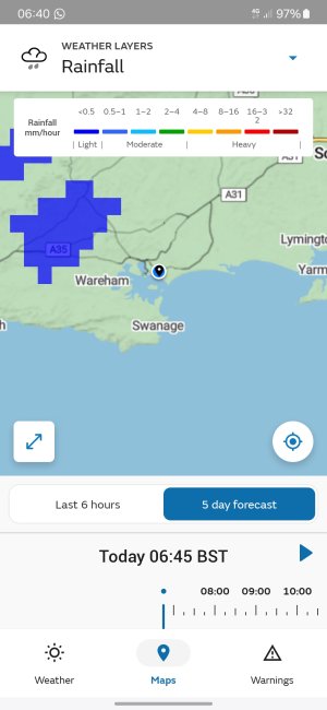
Hi Frank, funnily enough I was caught out by quite a heavy shower near the end of my morning walk today. Luckily I was close to home, otherwise I would have got very wet. As I was walking along I checked the Met office app, and the radar showed the image below (hoping this attaches properly). This shows no rain for at least 8 miles, but at the time there was the shower I was under (which took about 5 minutes to pass over) and I could see a couple of other similar-looking showers around the edges of Poole Harbour.

I'm not at all surprised that the radar fails to distinguish between low cloud, mist, fog and drizzle. A few years ago I led a team of engineers developing automated meteorological systems for UK and international airports, so I know how difficult it can be to make sense of such data. But as I said, using the Met Office app radar map, my confidence is moderate at best.
Screenshot_20240926_064052_Met Office.jpg
 

franksingleton

Well-known member
Joined
27 Oct 2002
Messages
3,550
Location
UK when not sailing
weather.mailasail.com
Drizzle / light rain and not showing on the radar I have found happening more and more. I rather assumed that it was too fine for the radar to pick up. I also use the Met Office app to access the rain radar.

I also feel that the Met Office are putting out to many weather warnings and then cancelling them, especially for rain. There is a heavy rain warning out for today but it is likely to be showery, possibly heavy.
There always has been a problem with drizzle, partly the small drop sizes, partly because drizzle forms in low cloud, typically in warm sectors of frontal lows. Because it is low down radar beams will pass over the cloud. I guess that we did not see this as a problem as our main partners were in the water industry. They were mainly concerned with rain run off.
 

franksingleton

Well-known member
Joined
27 Oct 2002
Messages
3,550
Location
UK when not sailing
weather.mailasail.com
Hi Frank, funnily enough I was caught out by quite a heavy shower near the end of my morning walk today. Luckily I was close to home, otherwise I would have got very wet. As I was walking along I checked the Met office app, and the radar showed the image below (hoping this attaches properly). This shows no rain for at least 8 miles, but at the time there was the shower I was under (which took about 5 minutes to pass over) and I could see a couple of other similar-looking showers around the edges of Poole Harbour.

I'm not at all surprised that the radar fails to distinguish between low cloud, mist, fog and drizzle. A few years ago I led a team of engineers developing automated meteorological systems for UK and international airports, so I know how difficult it can be to make sense of such data. But as I said, using the Met Office app radar map, my confidence is moderate at best.
View attachment 183478
To some extent, I think that you were unlucky today. To see ths latest actual radar image, you have to use UK rainfall radar map - Met Office. The first image on the app is a short term prediction. The actual at o645 showed a small band of showers just north of the coast. I do not know why these should not show on the predictions on the app. Maybe just too small for UKV with its 7.5km effective resolution.

For reasons thst I explained above, westher radar cannot see mist, cloud nor, more often than not, drizzle. Predictions of those are from NWP models. There is no relevant radar input. Rain seen on the radar is an input into models.
 

dunedin

Well-known member
Joined
3 Feb 2004
Messages
13,524
Location
Boat (over winters in) the Clyde
Visit site
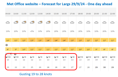
Now that this thread has drifted off into every other topic about weather models, perhaps bring back to the thread's specific point - that a few weeks back the Met Office online forecasts suddenly started regularly / always giving very high wind gust figures. Figures which were
(a) not shown on other forecast models;
(b) not shown in either of the Met Office models used on predict wind; and
(c) in almost all cases bore no relation to the actual weather on the day (over a period of many weeks).

My suspicion is that somebody has tweaked a few slides back again, as the degree of extreme pessimism in the Met Office web model seems to have reduced a bit in the last couple of weeks.

But it still seems to exist. Looking at whether to go sailing tomorrow, the forecast for 24 hours ahead we have:
- Met Office web forecast with winds 10-13mph (nice) - but gusting 19-28mpg (not nice with young family!)
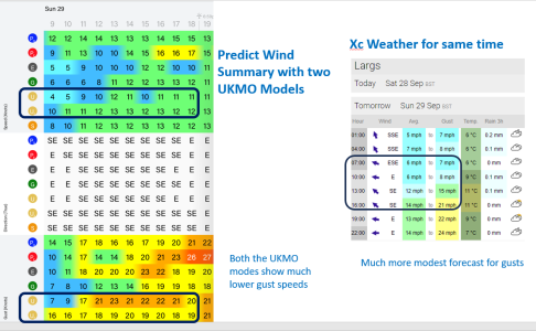
- Met Office on Predict Wind with U2 showing winds also 10-13mph but gusting a more reasonable 16-20mph
- XC Weather showing 6-14mph and gusting 8-21mph - with clear indication that getting breezier later in the day

So anybody care to explain why the Met Office web forecast consistently differs so much from the UKHO (both U and U2) models in Predict Wind.
This has been consistently out now for nearly 2 months and hass made met Office web forecast (previously my main reference) useless as "crying wolf" on most days.
 

Attachments

  • Screenshot 2024-09-28 150013.png
    Screenshot 2024-09-28 150013.png
    146 KB · Views: 5
  • Screenshot 2024-09-28 150037.png
    Screenshot 2024-09-28 150037.png
    354.7 KB · Views: 5

franksingleton

Well-known member
Joined
27 Oct 2002
Messages
3,550
Location
UK when not sailing
weather.mailasail.com
Meteo Consult has been spot on, through this unsettled season. And we have enjoyed superb passages, as a result. (Although some long stopovers have been required, to wait for our window). Less than a tank of diesel required from Chatham, down to La Rochelle and back up to Poole. Where we are now waiting out the forecast Bank Holiday blow.
Apologies to @franksingleton , who I know will counsel that all the sites peddle the same models. But, empirically, Meteo Consult seems to add some Gallic ‘secret sauce,’ of true divination!
Their admin HQ is in France but when I was trying to find what model(s) they use, I got a reply with a Czech or some othe East European address. They would not say which model they use on their web service. However, the only free service of forecasts out to 15 days is the GFS. Does anyone else think that the GFS is “spot on”.
 
Top