Snowgoose-1
Well-Known Member
Just too wide a banding for us in small boats. Something must have happened for them to change like this.
I have felt that this year the weather has been unsettled and quite often blustery and I suppose that the 'models' have reflected this.Just too wide a banding for us in small boats. Something must have happened for them to change like this.
At a guess they may be allowing for a far less stable atmosphere where geostrophic wind (above the friction layer) is more likely to be brought down to 10m surface level.Just too wide a banding for us in small boats. Something must have happened for them to change like this.
Interesting. I noticed fairly recently that windy.com (ECMWF model) has started showing orographic rain over out island on its map presentation from time to time. It was not there in the past, it only showed areas of frontal or unstable air mass precipitation. However, wind shadows thrown by the islands have been featured for quite a few years.I believe it's the local conditions that they're currently trialling ML to enrich after the traditional forecast model is done. Simon posted a link recently I think. In theory this would give us a bit of an advance in local accuracy for not a lot of additional effort since a lot of local effects are relatively easy to predict statistically.
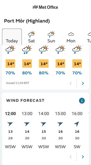
Met Office mean and gust forecasts for today, Port Mòr, MuckJust had a look at the local forecasts for Arisaig and Muck, where I am heading tomorrow, and no gust speeds
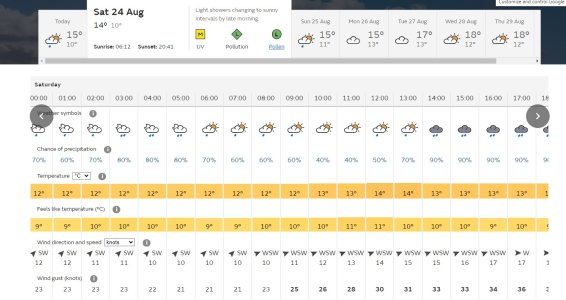
Yes but suddenly a month ago the Met Office website started having very pessimistic gust figures - eg 8 gust 24 etc.I am puzzled by many of the comments on this thread.
When assessing likely passage conditions, we take account of both the Met Office inshore forecast and their local land based forecast. The latter has included forecasts for both gusts as well as mean wind speeds for some time.
So, for example, the MO forecast for the Sound of Arisaig at 15:00 today is a mean speed of 19kts with gusts of 31kts.
") ). When I first put that live, I regularly crossed checked the displayed data with that of the Met Office forecast. The data always lined up exactly - which was nice! Now it doesn't. The average wind speed remains close and consistent - but the gust values don't align. Which sounds similar to the issue seen on Predict Wind (who presumably also call a Met Office API).
). When I first put that live, I regularly crossed checked the displayed data with that of the Met Office forecast. The data always lined up exactly - which was nice! Now it doesn't. The average wind speed remains close and consistent - but the gust values don't align. Which sounds similar to the issue seen on Predict Wind (who presumably also call a Met Office API).