GPS and swell height - no mention of anchors.

Neeves

Well-known member
Joined
20 Nov 2011
Messages
12,421
Location
Sydney, Australia.
Visit site
I've been mulling over how to measure swell height when at sea. Frankly I find it very difficult to arrive at a figure that seems right. The topic is a bit academic - swell height - it is what it is and you cannot do anything about it.

My understanding is that GPS can have the accuracy to a few millimetres, or centimetres. GPS can be used to measure altitude, or could be. Could a GPS be used to measure the difference in height, altitude, of a yacht as the yacht rises and falls over swell?

Jonathan
 

requiem

Active member
Joined
20 Mar 2019
Messages
198
Visit site
I think that level of accuracy is still a ways off. Certainly one can achieve it with the proper equipment, or by sitting still and averaging out readings, but ocean swells hardly count as still.

I suspect you'd get better numbers just from recording and plotting the output from a barometer app.
 

requiem

Active member
Joined
20 Mar 2019
Messages
198
Visit site
What about the echo sounder

Depends. They tend to give up once the water gets sufficiently deep, and you'd also want a known bottom. Something like this might mess with your data:
sea_floor_mapping.jpg
 

Refueler

Well-known member
Joined
13 Sep 2008
Messages
18,365
Location
Far away from hooray henrys
Visit site
GPS altitude is innacurate - that is why such as Photo Drones with full sophisticated GPS units on board use two additional systems, I am not talking about the cheap supermarket toys !! :

Barometer for general height measurement
+
Optical / Sonic detector for near ground determination up to about 10m height.

My DJI Pro is good enough for me to detect the fall of ground at my house to river ... I can take off on the high ground - which registers as zero ... then land further along the garden and it will display the rise or fall amount .... I have even used it to measure the huge Christmas tree I have out the back ... last flight recorded it at 31m tall.

Only problem though - such a unit would not be usable for such job on board as it needs to be stationary for about 20secs to initialise sensors ...
 

Roberto

Well-known member
Joined
20 Jul 2001
Messages
5,155
Location
Lorient/Paris
sybrancaleone.blogspot.com
Swell or waves? A 0.5-1m swell with 150m wave length will not be visible (but still possibly be dangerous while approaching a shore)... For wind wave height, stand on the boat and when you see the top of a wave aligned with the horizon that wave height will be the height of your eyes over the water level. Repeat and average.
With big waves one might need to climb up the mast :D
 

Buck Turgidson

Well-known member
Joined
10 Apr 2012
Messages
3,226
Location
Zürich
Visit site
Swell or waves? A 0.5-1m swell with 150m wave length will not be visible (but still possibly be dangerous while approaching a shore)... For wind wave height, stand on the boat and when you see the top of a wave aligned with the horizon that wave height will be the height of your eyes over the water level. Repeat and average.
With big waves one might need to climb up the mast :D
👍 2m when I'm standing and 1.5 when I'm sitting in the cockpit. This is how I estimate wave height. I calculated the eye height for astro.
 

Graham_Wright

Well-known member
Joined
30 Dec 2002
Messages
7,770
Location
Gloucestershire
www.mastaclimba.com
Depends. They tend to give up once the water gets sufficiently deep, and you'd also want a known bottom. Something like this might mess with your data:
That doesn't seem right. Swell height is an instantaneous measurement. The bottom depth is unlikely to change much in a few metres of lateral distance. Seems a pretty sound method to me.
 

Refueler

Well-known member
Joined
13 Sep 2008
Messages
18,365
Location
Far away from hooray henrys
Visit site
And what about the 'beam pivot effect' that will affect the persons position relative to horizontal ?

Imagine sitting in the boat at aft end of cockpit. Boat is pivoting about its CoG as the waves pass through. The ends of the boat technically will rise and fall more than the central pivot point rises and falls ...

I know its all technical ...
 

AntarcticPilot

Well-known member
Joined
4 May 2007
Messages
10,156
Location
Cambridge, UK
www.cooperandyau.co.uk
GPS is hopeless at accurate altitude.
It depends. GPS is CAPABLE of very high precision - a few centimetres, or even better (millimetre accuracy is feasible!) HOWEVER this is not available in real time without an elaborate survey system with a fixed base station as well as the mobile station, with a radio link between the two, or recording carefully timestamped signals at both locations simultaneously and post-processing the data. You need to record things like the phase of the signal as well as the digital information used by consumer-grade equipment. It can't be attained using the kind of kit we have access to! My colleagues routinely attained centimetre accuracy in the Antarctic, and some of my geophysics colleagues were measuring to millimetre accuracy (they were measuring plate movement, and tectonic plates move at rates comparable to the rate at which our fingernails grow!.)

@tillergirl is sort of right. Consumer grade GPS is about 50% worse in the vertical dimension than the horizontal - that is, if you've got a horizontal accuracy of 2 metres, the vertical accuracy will be about 3 metres. The absolute accuracy isn't that different. However, we perceive the vertical accuracy as being lower, because a horizontal distance of 2 metres is 2-3 paces, but a vertical distance of 3 metres is a flight of stairs, and is comparable to tidal ranges! There's also the issue that GPS measures height with respect to a notional surface called the ellipsoid, and this deviates from gravitational datums like LAT or OS Datum by an amount which may be up to 100metres (in the UK it's usually around 15m). That's not a big issue, as the offset is constant at a particular location and fairly easy to determine (there are online tools using more accurate models of the earth that will give the offset at any location).

Anyway, the bottom line is that you can't easily measure swell using GPS. A better technique would be to monitor the depth sounder; shorter waves will tend to be filtered out, so swell should show as a long-period variation in the measured depth. @fisherman has reported observing this in calm conditions when there were no short-period waves, but it should be feasible; the difficulty might be avoiding the effect of short-period waves. Oceanographers do this in reverse - they place an upward-looking sounder on the sea floor.
 

Roberto

Well-known member
Joined
20 Jul 2001
Messages
5,155
Location
Lorient/Paris
sybrancaleone.blogspot.com
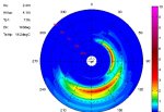
Also, if one wants to use instruments to get a sharp definition of an oscillating body (sea state) which is very non-monochromatic (several frequencies add up to the final movement), to get a meaningful data you soon need to describe what are the main components of that movement. Saying "swell is 2.7697669001m" is a lot less meaningful than computing a diagram like the one below (this one showing periods instead of Hz): main component SSE at 7s (wind wave), superimposed to a ENE 10s swell. That's what oceanographic buoys measure, or wave forecasting models output, calling them wind wave - primary /secondary swell etc.
Instead of instruments one can just use gut feeling "what an uncomfortable cross sea" :)


dir spectra.jpg
 

AntarcticPilot

Well-known member
Joined
4 May 2007
Messages
10,156
Location
Cambridge, UK
www.cooperandyau.co.uk
As post #15 ... has mentioned - it also needs to account for the local wind driven waves imposed upon the swell
A mitigating effect is that the hull of the boat will filter out short wavelengths, at least to some extent.

If I were approaching this - and I know from oceanography colleagues that this is a non-trivial problem - I'd be looking at taking continuous depth sounder measurements and then using Fourier analysis to produce a wave spectrum. However, as @Roberto says, you really need data in two dimensions to gain a good idea of the wave field, so no measurement we can feasibly do from our boats is going to cut the mustard in terms of detail. Even swell waves may result from the combination of wave trains from different directions; when you include the effect of local waves, you've got a very difficult problem. Fourier analysis of data from a single depth sounder would indicate two trains with different periods, but wouldn't indicate the direction of each train.
 

Refueler

Well-known member
Joined
13 Sep 2008
Messages
18,365
Location
Far away from hooray henrys
Visit site
Having spent years on ships bridges filling in Weather Reports ... the subject of wave height / Swell form and height was a truly difficult one. Even Meteo who included manual with the report books / gear suggested using the wind force assessment which then had height range indicated etc.
They accepted that accurate results were near impossible.

It was also obvious to me as a ships officer and also a yottie - that assessment of waves were vastly different between the two ... on a yacht - it always seemed much more ....
 

AntarcticPilot

Well-known member
Joined
4 May 2007
Messages
10,156
Location
Cambridge, UK
www.cooperandyau.co.uk
Having spent years on ships bridges filling in Weather Reports ... the subject of wave height / Swell form and height was a truly difficult one. Even Meteo who included manual with the report books / gear suggested using the wind force assessment which then had height range indicated etc.
They accepted that accurate results were near impossible.

It was also obvious to me as a ships officer and also a yottie - that assessment of waves were vastly different between the two ... on a yacht - it always seemed much more ....
The measure used in satellite measurements, Significant Wave Height, was chosen to be as close as possible to the heights reported by "experienced maritime observers". Were you ever on a Selected Observer Ship? I think they have to have predefined procedures for estimating things like wave height in place. I have no experience myself, but of course, BAS ships were part of that programme.
 
Top