GPS and swell height - no mention of anchors.

fisherman

Well-known member
Joined
2 Dec 2005
Messages
19,675
Location
Far S. Cornwall
Visit site
In my case I had an echo sounder with several functions including bottom expansion, (fnar fnar) when it would show the bottom selected few metres on the whole screen; I could select for a display of several 1000mts or 1mt, and I also had a trace record across the screen that I could slow down to give me a short historical record, plus a depth scale on screen or up the side. This would give me an accurate assessment of wave height.
 

Supertramp

Well-known member
Joined
18 Jul 2020
Messages
1,022
Location
Halifax
Visit site
Wave height (or swell height) needs the context of the wave form - the wave length and the period. Often "exciting" waves are not so much high as short. Ocean swells several metres high may have negligible effect on a small boat but be throwing spray the length of a freighter. Conversely a short sea of 1 or 2m can create a fairground ride on a small boat. The perception of those different waves will distort the estimates!

As to measuring, an echo sounder with a fast enough response rate and no smoothing or averaging feels like the best way. When it's big enough to measure, I am usually preoccupied with other matters!

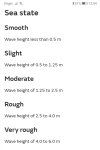
I always like the forecast way of describing the seas as smooth, slight, moderate etc all the way up to phenomenal. Screenshot_20230223_135521.jpg
While it's encouraging to know the wave height will only be a metre or two, it gets over exciting when the wavelength decreases to a boat length or so!
 

Refueler

Well-known member
Joined
13 Sep 2008
Messages
20,446
Location
Far away from hooray henrys
Visit site
The measure used in satellite measurements, Significant Wave Height, was chosen to be as close as possible to the heights reported by "experienced maritime observers". Were you ever on a Selected Observer Ship? I think they have to have predefined procedures for estimating things like wave height in place. I have no experience myself, but of course, BAS ships were part of that programme.

Various ships were part of the Weather Reporting system ... so it was usually 3rd or 2nd Mates job to complete each day a sheet ... it had coded sentences from a reporting book ... sparky would then send the strings of code to the designated receiving station.
Yes the days when we had R/O's . Later it was by email via satelite
It took (if done diligently !! ) about 20 mins to complete the paper. Once you'd done a few - it was about 5 - 10mins depending on how bad the weather. On the bridge were wall charts of cloud types ... wave forms .... wind tables .... etc. We'd have a handheld anemometer + the mast mounted fixed ... a Wet and Dry cabinet on the bridgewing .....

All good stuff !!

It was common to see 'Thank You Plaques' on the bulkhead for each year the ship had completed ... alongside such as the AMVER shields ....

Most ships I sailed were 'reporters' .....
 

Refueler

Well-known member
Joined
13 Sep 2008
Messages
20,446
Location
Far away from hooray henrys
Visit site
In my case I had an echo sounder with several functions including bottom expansion, (fnar fnar) when it would show the bottom selected few metres on the whole screen; I could select for a display of several 1000mts or 1mt, and I also had a trace record across the screen that I could slow down to give me a short historical record, plus a depth scale on screen or up the side. This would give me an accurate assessment of wave height.

CGG - had two converted Stern Trawlers and one converted French MInesweeper. The trawlers still had their deep sonars and the side scan sonars on board left over from 'fishing days' ..... we could not run them during shoots of course - but we often played with them when not shooting.

Interesting days towing 3 mile cables !!
 

AntarcticPilot

Well-known member
Joined
4 May 2007
Messages
10,539
Location
Cambridge, UK
www.cooperandyau.co.uk
CGG - had two converted Stern Trawlers and one converted French MInesweeper. The trawlers still had their deep sonars and the side scan sonars on board left over from 'fishing days' ..... we could not run them during shoots of course - but we often played with them when not shooting.

Interesting days towing 3 mile cables !!
And I still remember it well, nearly 50 years on! "Oil Hunter" - a converted stern trawler - was the boat I was on.
 

Refueler

Well-known member
Joined
13 Sep 2008
Messages
20,446
Location
Far away from hooray henrys
Visit site
I know its not the subject here .... but here's a story ...

Vessel ST Zaphon, loaded with 60,000 tons of Nigerian crude sailing north .. destination Rotterdam.

I was Cadet and on the bridge with the 3rd Mate .... Chinese crew on deck painting as usual. We were about 1/2way across Bay of Biscay .... this day not rolling as was usual from the atlantic swell. Some trips we would roll the bilge out of the water ... UGH ! But anyway - all was quiet ... steaming along 15kts ...
Suddenly BHAM ... the biggest rogue wave I have ever seen before or since hit the bow ... with the flared bulwarks - the water curled up and over and travelled whole length of ship ... never touched deck - hit the accommodation aft and ripped off the teak handrails causing them to fly up higher than us on the bridge .. buckled the forward watertight doors ....
The crew ? Never touched ...

QwDLesSl.jpg


Another fact about this ship ... she was very long and narrow for her tonnage. Built originally as 35,000 DWT - she and her sister Zenatia were with powerful steam turbines. Shell decided to Jumbo-ise the two vessels to 69,000 DWT .... and the incredible thing is - they were FASTER after the increase.
The original design was with midships accommodation and aft. When they jumbo'd - they put the midships housing on top pf the aft as you see in the photo. This put the centre-castle stores halfway up the accomm's !
The 4 parts that were original .... Bow, Stern with engine room, midships and aft accommodation. The cargo tanks were all new.
 

srm

Well-known member
Joined
16 May 2004
Messages
3,248
Location
Azores, Terceira.
Visit site
The survey sounders I used were all phased scale (not allowed for navigation because of risk of miss reading the depth), this effectively magnified the vertical scale on the paper trace to allow depth measurement to 0.1 metre. The bottom trace usually had a wave form due to the heave of the ship or roll if the transducer was mounted off the centre line. The later was the norm as we chartered vessels for the contract and fitted our own portable survey and geophysical instruments, usually clamping a pole carrying the sounder transducer to the bulwark and towing the geophysical transducers and sidescan. When plotting the soundings we smoothed the sea bed wave form and used a mid depth.
 

lustyd

Well-known member
Joined
27 Jul 2010
Messages
12,405
Visit site
The 9 axis compasses can do it. They measure acceleration in all directions as well as rate of turn in all axis. No different to a Garmin watch measuring vertical oscillation (bounce height) while running just a bit more correction to get vertical movement.
 

Uricanejack

Well-known member
Joined
22 Oct 2012
Messages
3,750
Visit site
I know its not the subject here .... but here's a story ...

Vessel ST Zaphon, loaded with 60,000 tons of Nigerian crude sailing north .. destination Rotterdam.

I was Cadet and on the bridge with the 3rd Mate .... Chinese crew on deck painting as usual. We were about 1/2way across Bay of Biscay .... this day not rolling as was usual from the atlantic swell. Some trips we would roll the bilge out of the water ... UGH ! But anyway - all was quiet ... steaming along 15kts ...
Suddenly BHAM ... the biggest rogue wave I have ever seen before or since hit the bow ... with the flared bulwarks - the water curled up and over and travelled whole length of ship ... never touched deck - hit the accommodation aft and ripped off the teak handrails causing them to fly up higher than us on the bridge .. buckled the forward watertight doors ....
The crew ? Never touched ...

QwDLesSl.jpg


Another fact about this ship ... she was very long and narrow for her tonnage. Built originally as 35,000 DWT - she and her sister Zenatia were with powerful steam turbines. Shell decided to Jumbo-ise the two vessels to 69,000 DWT .... and the incredible thing is - they were FASTER after the increase.
The original design was with midships accommodation and aft. When they jumbo'd - they put the midships housing on top pf the aft as you see in the photo. This put the centre-castle stores halfway up the accomm's !
The 4 parts that were original .... Bow, Stern with engine room, midships and aft accommodation. The cargo tanks were all new.
A real Tankerman from Ye Old Exploding Tanker Co. :).
 

Uricanejack

Well-known member
Joined
22 Oct 2012
Messages
3,750
Visit site
The measure used in satellite measurements, Significant Wave Height, was chosen to be as close as possible to the heights reported by "experienced maritime observers". Were you ever on a Selected Observer Ship? I think they have to have predefined procedures for estimating things like wave height in place. I have no experience myself, but of course, BAS ships were part of that programme.
Every Ship I sailed on. The Voluntary Observing Ship . Can’t remember if selected Was part of the title or deal. The UK met office has about a decades worth of my efforts in log books in some attic somewhere. They used to publish a nice little book of special phenomena reports. I put one in for a water spout once. Which got published.
The companies liked it. Partly because the met office gave us good quality proper scientific gear to observe with.
Presision Anneroid Baromoters.
Met office barograph.
loads of properly calibrated thermometers
Stevens Screens..
and a little rubber bucket to collect sea water for the sea temp.

Its been a few decades, I find it hard to rember where I parked the car. hopefully I can still rember how I used to do the weather reports.

Sea state, Well , The wind waves, then the 1st swell and the 2nd Swell. I think there was even room for a 3rd if you were really enthusiastic.
Reputedly. The most inaccurate part of our reports.
interestingly the met office much preferred us to estimated wind speed rather than using anemometers.
To this day I prefer use my estimate from the Beaufort scale ahead of an anemometer.

On bigger vessels we probably underestimated sea state on small vessels it’s probably over estimated. Looks quite different depending upon where you are standing. I think it’s a bit easier from a ship than a small sailing vessel.

Every 6 hours, At 0000 Z 0600Z 1200Z 1800Z as Refuler said about 20 min to do a full observation. But. Could cut this down some by prepping ahead.
if in the vicinity of a TRS we would do every 3 hours. Which could make things interesting trying to get a Sea temp and wet and dry temps.
I found a lot of times I just couldn’t see well enough at night to get the swell unless it was pretty big or maybe I was just being lazy.
Out onto the windward wing by the repeater. Sight across the wave tops with the azimuth ring. You just logged the nearest 10 deg or about 1 point.
Count the seconds, as the crests go by.
this gives direction and period. Probably reasonably accurate guessin.
for hight.
My rough rule of thumb average about 1m per second of period ish. If shorter and steeper a bit more hight if longer and lower a bit less hight.
if there are some white caps you can watch a bit of white to time the crests. If not it’s sometimes easier look astern and to use your wake

The wind is easy.

look for the swell, basically do the same, this time for the swell.
The first swell is the easier seen, higher and shorter. than the second ect.
Thee swell is a bit harder to see but you get better with practice.

sometimes it’s hard to see accros the crests of the swell, so you sight along the crest. And the direction is +- 90.

Truth is, it’s rare to only have the wind waves offshore unless you are down by the doldrums. Or perhaps in the trades. Even there there . Ussualy a swell from the mid latitudes.

Watching the wind direction and swell in the trades was a very important along with the barograph.
I don’t know, does the OYM go through the warning signs of a TRS and how to predict where it is and which sector you are in. I presume it does.
If not it’s in the W anchors guide to universe. Or HM publication The mariners handbook.

Or as the guide says keep a weather eye on the sky and the sea.

In some ways I miss the old bridge wings and having the Lee door always open.
Now with fully enclosed wings AC and central heat. It is nice to be comfortable but, I miss seeing the sky.

Why do you want to watch these,

Some old farts law. Byballot. who ever he was.
Arrr Stand with yer back at the wind there Jim lad. And stick yer left arm out the center of the low is over yonder or submit like that.
The first swell will tell you where the center of the low was 12 to 24 hrs ago
The second will tell you where it were before that.

How far away,? you guess, depending on how big the waves and swell is. The wind direction, strength, latitude, clouds type ect.

I kind of liked doing the weather reports, made you pay attention, gave you something to do, you learned a lot. and writing meteorology or navigation exams easy peassy.

Even in this day and age, if I know a young un is plannng on going for a certificate. I will suggest they start to keep a notebook log of thier own daily observations. watch the sky and the sea. Ypu will soon figure out what happens.

Its surprising how much easier it is when you have watched it happen than trying to reading it from a text book.
 
Last edited:

Refueler

Well-known member
Joined
13 Sep 2008
Messages
20,446
Location
Far away from hooray henrys
Visit site
A real Tankerman from Ye Old Exploding Tanker Co. :).

I know it was not meant as a bad reply.

The fact was at that time - Inert Gas use was still in pioneer stage - in fact was initiated to reduce in tank corrosion, not to reduce the risk of explosion. The problem was that the Inert Gas either had no effect or even increased corrosion. But the side effect of reducing risk of explosion was noted.
There were a series of catastrophies involving 3 Shell VLCC's (200,000 DWT) ... Mactra, Marpessa and I forget the name of the 3rd ... along with a couple of chartered vessels - one being the King Harcon.... think I have the name right.

At that time - we relied on the TOO LEAN atmosphere for tank cleaning .... we would force ventilate the tank to be cleaned till oxygen level was below 5% ... 2% if possible. Oxygen and Hydrocarbon gas levels were monitored during the wash cycle and if rose above the 5% level - washing would cease while venting continued.
At that time we did not do Crude Oil Washing while discharging as we had no way to ensure risk free operation.

Once Inert Gas (actually exhaust gas from main engine or IG generator scrubbed clean of sulphur) was introduced into tanks to reduce oxygen content - then Crude Oil Washing became common. This then reduced the sediments left in bottom of tanks from successive cargos.

Back to the ships ... the case of the Mactra - this was never completely solved in terms of the explosion that ripped her open for near 1/3rd her deck. Various experiments and inquiries ... such as at Southampton University - could not explain the blast effects ... where not all bulkheads failed in same manner as in a single explosion would have. The deck was literally ripped open and folded back ... a bulkhead blown out ... another blown in ... The damage was such that a completely new hull top was built to repair her .... as with others.

The human cost - People on deck did lose their lives ....wives sunbathing on top of the accommodation were burnt from the flash over and flying metal.

All were during ballast voyages and most when tank cleaning with high pressure sea water. Test conducted by Southampton University showed the Static Electric effect of water droplets falling from the underdeck down to tank floor. It is this that was believed to have been the 'spark' that blew these ships asunder. Prior to this of course - it was easy for blame to be on a crew member on deck at the time.

OK ... sea waves and damage to ships .....

Texaco Oklahoma ... a midships accom MRCC tanker .....

She had undergone USCG periodic inspection as req'd by US Flag rules ... this usually entailed a structural check - but because of it being a repeated inspection through ships life - they alternated tank groups internal checks.
She was checked and cleared ... and she returned to service.
During a subsequent voyage - she encountered heavy seas and the ship actually fractured just aft of the midships accommodation. Sadly - USCG had given permission for decommissioning for repairs to 2 of the 4 ships lifeboats .... as the front half broke away - it veered round and smashed alongside the aft section destroying the only two in service Lifeboats.
The front section immediately sank taking all Navigating Officers and Master with it.
The aft section was left floating .. with Engineers and Seaman Crew. They had the emergency Radio - ships radio stations were midships on such vessels which of course was now sunk. The crew tried using the radio - but after rescue - it was found they still had the test bridge bar in place preventing transmission signal.
Other ships actually sailed past and later when asked said they just thought it was a strange design of ship ...
Finally engineers and crew were rescued and became a lesson for shipping in general.

As far as I can tell - USCG were never held to account for their part in the disaster.

Sorry for thread drift .....
 

Refueler

Well-known member
Joined
13 Sep 2008
Messages
20,446
Location
Far away from hooray henrys
Visit site
Every Ship I sailed on. The Voluntary Observing Ship . Can’t remember if selected Was part of the title or deal. The UK met office has about a decades worth of my efforts in log books in some attic somewhere. They used to publish a nice little book of special phenomena reports. I put one in for a water spout once. Which got published.
The companies liked it. Partly because the met office gave us good quality proper scientific gear to observe with.
Presision Anneroid Baromoters.
Met office barograph.
loads of properly calibrated thermometers
Stevens Screens..
and a little rubber bucket to collect sea water for the sea temp.

Its been a few decades, I find it hard to rember where I parked the car. hopefully I can still rember how I used to do the weather reports.

Sea state, Well , The wind waves, then the 1st swell and the 2nd Swell. I think there was even room for a 3rd if you were really enthusiastic.
Reputedly. The most inaccurate part of our reports.
interestingly the met office much preferred us to estimated wind speed rather than using anemometers.
To this day I prefer use my estimate from the Beaufort scale ahead of an anemometer.

On bigger vessels we probably underestimated sea state on small vessels it’s probably over estimated. Looks quite different depending upon where you are standing. I think it’s a bit easier from a ship than a small sailing vessel.

Every 6 hours, At 0000 Z 0600Z 1200Z 1800Z as Refuler said about 20 min to do a full observation. But. Could cut this down some by prepping ahead.
if in the vicinity of a TRS we would do every 3 hours. Which could make things interesting trying to get a Sea temp and wet and dry temps.
I found a lot of times I just couldn’t see well enough at night to get the swell unless it was pretty big or maybe I was just being lazy.
Out onto the windward wing by the repeater. Sight across the wave tops with the azimuth ring. You just logged the nearest 10 deg or about 1 point.
Count the seconds, as the crests go by.
this gives direction and period. Probably reasonably accurate guessin.
for hight.
My rough rule of thumb average about 1m per second of period ish. If shorter and steeper a bit more hight if longer and lower a bit less hight.
if there are some white caps you can watch a bit of white to time the crests. If not it’s sometimes easier look astern and to use your wake

The wind is easy.

look for the swell, basically do the same, this time for the swell.
The first swell is the easier seen, higher and shorter. than the second ect.
Thee swell is a bit harder to see but you get better with practice.

sometimes it’s hard to see accros the crests of the swell, so you sight along the crest. And the direction is +- 90.

Truth is, it’s rare to only have the wind waves offshore unless you are down by the doldrums. Or perhaps in the trades. Even there there . Ussualy a swell from the mid latitudes.

Watching the wind direction and swell in the trades was a very important along with the barograph.
I don’t know, does the OYM go through the warning signs of a TRS and how to predict where it is and which sector you are in. I presume it does.
If not it’s in the W anchors guide to universe. Or HM publication The mariners handbook.

Or as the guide says keep a weather eye on the sky and the sea.

In some ways I miss the old bridge wings and having the Lee door always open.
Now with fully enclosed wings AC and central heat. It is nice to be comfortable but, I miss seeing the sky.

Why do you want to watch these,

Some old farts law. Byballot. who ever he was.
Arrr Stand with yer back at the wind there Jim lad. And stick yer left arm out the center of the low is over yonder or submit like that.
The first swell will tell you where the center of the low was 12 to 24 hrs ago
The second will tell you where it were before that.

How far away,? you guess, depending on how big the waves and swell is. The wind direction, strength, latitude, clouds type ect.

I kind of liked doing the weather reports, made you pay attention, gave you something to do, you learned a lot. and writing meteorology or navigation exams easy peassy.

Even in this day and age, if I know a young un is plannng on going for a certificate. I will suggest they start to keep a notebook log of thier own daily observations. watch the sky and the sea. Ypu will soon figure out what happens.

Its surprising how much easier it is when you have watched it happen than trying to reading it from a text book.

ST Latia, (320,000 DWT) .... the 'standing' Master for that Vessel was a Fellow of the Natural History Museum and Member of Royal Ornithological Society .....
I was Extra 3rd Mate and was unusually given the 4-8 watch. Junior 3rd Mate had the usual 3rd Mates 8-12.
Anyway - I was asked that when I did 'stars' in the morning - to then alter course for a small island in the Indian Ocean ... Shell had an agreement with the Master that he could divert of course for such if it did not incur too much delay ...
Basically he had rec'd info about an event that occurs periodically near this island .... SWARMING SWIMING CRABS and various birds attracted ... so it was intent to see if we could observe the crabs and what birds ....
Stars plotted ... course set ... of we went ... about 1030 island in view .. 3/O literally panicked and started altering course away from the island ... Master immediately ordered return to course.... the islands such as this are volcanic and have deep water right up close - so there was no danger at all ... and we were still a long way off.
Yes we observed the Crabs ... he even got some Photos from deck level. Birds ? no idea - but there were a lot ! But not apparently not feeding on the Crab.
Master sent in report to NHM and Shell, I was mentioned - but when published I was not mentioned ... only Shell, Ship and Master.

Life !
 

Neeves

Well-known member
Joined
20 Nov 2011
Messages
13,104
Location
Sydney, Australia.
Visit site
The 9 axis compasses can do it. They measure acceleration in all directions as well as rate of turn in all axis. No different to a Garmin watch measuring vertical oscillation (bounce height) while running just a bit more correction to get vertical movement.


I'd forgotten about the accelerometer in modern electronics.

I had promised my self to use the app Scramp, ‎SCraMP, or one of the other apps -but become sidetracked.,

There are better people, much better, than me - so how about the accelerometer in your iPad or phone and, say, the Scramp App.

Interms of swell and waves. I'm differentiating by wave length, ocean swells have a very long wave length and short term, today's waves, wind driven waves have short wave length. You might get many wind driven waves within the wave length of what I call swell.

I did wonder about Refueler's comment about standing on the stern, bow, or amidships of a large vessel and estimating the pitch of the vessel in long wave length swell - but that's not of much use on a yacht.

And yes, I know, its academic as the waves and swells are what they are - and you can do little about it. But in the data driven world it seemed there must be a way of measuring wave height, with ease.

Jonathan
 

boomerangben

Well-known member
Joined
24 Jul 2003
Messages
1,225
Location
Isle of Lewis
Visit site
The 9 axis compasses can do it. They measure acceleration in all directions as well as rate of turn in all axis. No different to a Garmin watch measuring vertical oscillation (bounce height) while running just a bit more correction to get vertical movement.
Possible, but you need to know what the response amplitude operators are for the location in the vessel where your 9 axis compass is. In other words, vessels don’t necessarily move by the same amount the wave does (unless of course the vessel is small compared with wave height). If your compass isn’t at the centre of floatation, you would have to remove the effects of pitch and/or roll. Would work with a buoy but then you have to somehow separate the waves of differing frequencies superimposed on each other.
 

AntarcticPilot

Well-known member
Joined
4 May 2007
Messages
10,539
Location
Cambridge, UK
www.cooperandyau.co.uk
And yes, I know, its academic as the waves and swells are what they are - and you can do little about it. But in the data driven world it seemed there must be a way of measuring wave height, with ease.

Jonathan
Unfortunately, many oceanographers wish this were true! Over the years, a vast amount of effort has been expended on measuring wave fields, and even now new findings are coming out. The problem is that measurement at a single point doesn't give enough information, and measurement over an area is difficult and doesn't necessarily reflect what a small vessel experiences. Satellite measurements are the "best" way of measuring wave heights averaged over a fairly substantial area (kilometres), and that's a pretty mature field - we were doing it routinely in the late 70s and early 80s, and these days it's a routine product from satellites. But those measurements don't give the wave spectrum or direction. And as @Roberto pointed out, without directional information, the wave field is undefined. It matters because constructive and destructive interference between different wave trains can result in unusually large waves or unusually deep "holes". There are also matters like the statistical distribution of wave sizes - only a few years ago, it was found that the distribution differs substantially from the conventional normal distribution, with a much higher proportion of extreme events than would be predicted by a simple model.

The bottom line is that no measurement at a single point will give enough information to be useful in a predictive sense and beyond bragging rights (my wave was bigger than yours) it's hard to see what use it would be.
 

boomerangben

Well-known member
Joined
24 Jul 2003
Messages
1,225
Location
Isle of Lewis
Visit site
I'd forgotten about the accelerometer in modern electronics.

I had promised my self to use the app Scramp, ‎SCraMP, or one of the other apps -but become sidetracked.,

There are better people, much better, than me - so how about the accelerometer in your iPad or phone and, say, the Scramp App.

Interms of swell and waves. I'm differentiating by wave length, ocean swells have a very long wave length and short term, today's waves, wind driven waves have short wave length. You might get many wind driven waves within the wave length of what I call swell.

I did wonder about Refueler's comment about standing on the stern, bow, or amidships of a large vessel and estimating the pitch of the vessel in long wave length swell - but that's not of much use on a yacht.

And yes, I know, its academic as the waves and swells are what they are - and you can do little about it. But in the data driven world it seemed there must be a way of measuring wave height, with ease.

Jonathan
Electronics will measure accelerations where the iPad is. The data can be integrated to get distance moved. But that is only measuring how the iPad is moving (and the boat) but not the wave. Boats don’t necessarily move by the same amount the water does, sometimes more if the wave frequency is close to the natural freq of the vessel, sometimes less, but rarely constant. Wave height I think is analogous to fish size in the pub 😂
 

lustyd

Well-known member
Joined
27 Jul 2010
Messages
12,405
Visit site
Possible, but you need to know what the response amplitude operators are for the location in the vessel where your 9 axis compass is. In other words, vessels don’t necessarily move by the same amount the wave does (unless of course the vessel is small compared with wave height). If your compass isn’t at the centre of floatation, you would have to remove the effects of pitch and/or roll. Would work with a buoy but then you have to somehow separate the waves of differing frequencies superimposed on each other.
Supposed to be installed in the centre of the boat for this very reason, but yes you'd want to calibrate. It's not incrementally much harder though.

Regarding wave vs swell, I would consider the waves to be noise on the swell so easy enough for an ML model to differentiate.
 

AntarcticPilot

Well-known member
Joined
4 May 2007
Messages
10,539
Location
Cambridge, UK
www.cooperandyau.co.uk
Supposed to be installed in the centre of the boat for this very reason, but yes you'd want to calibrate. It's not incrementally much harder though.

Regarding wave vs swell, I would consider the waves to be noise on the swell so easy enough for an ML model to differentiate.
It's not just calibration. The boat's response to waves will be stronger at some frequencies and weaker at others, and stronger in some directions and weaker in others. Just for example, think of the difference between hitting waves bow or stern on and hitting the same waves beam on. Without information about the direction of travel of the waves, which is not available from a single sensor, you can't make deductions about the wave train in general.

ML can do wonderful things, but also remember that it's very good at magnifying error; look at the number of studies of ML for images where tiny differences in the image data have resulted in massive changes in the output; indeed image spoofing is a real thing, where images clearly the same to an observer are classified into different and sometimes antithetical classes by ML on the basis of almost invisible differences - a classic sign of error being amplified. ML also requires ground truth to create a training dataset, and there isn't one available in this case.
 

lustyd

Well-known member
Joined
27 Jul 2010
Messages
12,405
Visit site
Perfect is the enemy of good. OP just wanted a way to measure swell while on board. While interesting, it's unhelpful to assume that his requirement is a perfect representation of the environment. We can get close enough, most of the time with a 9 axis sensor, and ML removes most of the legwork in that. Yes, ML can cause issues for those who don't understand it. For those that do, it'll easily handle this problem, and a 9 axis sensor will probably provide enough feedback to determine direction given sufficient training data.
 
Top