earlybird
Well-Known Member
From Hiscock, "Cruising Under Sail"; the Southern Ocean tidal wave is deflected northwards up the length of the Atlantic Ocean taking approx 2 days to reach the UK when it augments the normal tidal range.
Some will never be fully satiatedI have never fully understood it myself. All the explanations I've heard or read to date - usually mentioning the inertia of the mass of the oceans and seabed / landmass constraints - are insufficiently specific to fully satisfy me

AIUI, that's the starting point, but the gravitational influence is tiny. It's a bit like pushing someone on a swing, a tiny push at the right time adds to the movement, so it builds up, but most of it is just a wave going round the oceans. Then the land gets in the way and complicated things.The sun pulls a bulge of water that moves because the planet rotates, sometimes the sun and moon are together causing a larger tide , ie spring tide and a black new moon , the other set of tide the moon and sun are opposite sides to earth and the moon can be seen lit by the sun these are neap tides.
From my reading, I think that friction is part of the explanation, as well as inertia.Yes, the OP clearly knows that, but is asking why there is such a lag.
I have never fully understood it myself. All the explanations I've heard or read to date - usually mentioning the inertia of the mass of the oceans and seabed / landmass constraints - are insufficiently specific to fully satisfy me.
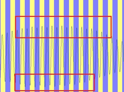
The amplitude of the tidal curve increases towards springs and decreases towards neaps. The envelope of the curve has a maximum at springs and a minimum at neaps. My question about the time of springs is therefore about the time of the maximum of the envelope.The shape of tidal curves is basically close to a sine wave, in a simple case where tides are not much affected by Islands and what have you.
When Islands or coasts affect the tidal flow, the curve changes shape, this can be expressed as 'harmonics' on the fundamental wave.
The more harmonics, the more you depart from the simple model of a neap tide being a small sine wave and a spring tide being the biggest.
I would assume that a Spring tide day is a spring tide day everywhere,
Where would you draw the upper/lower envelope?The amplitude of the tidal curve increases towards springs and decreases towards neaps. The envelope of the curve has a maximum at springs and a minimum at neaps. My question about the time of springs is therefore about the time of the maximum of the envelope.

Thank you for your link to the NOAA website and your invitation to report back. It provides a very clear explanation of the basic features of the tides. However, as far as I could see, it does not mention the fact that springs and neaps do not occur at the same time as the phase of the moon that causes them, but afterwards, nor that this lag varies from month to month.Some will never be fully satiatedbut have a read here Types and Causes of Tidal Cycles - Tides and Water Levels: NOAA's National Ocean Service Education
and at the associated tabs (on the right) then please report back.
That is for mathematicians to decide, and I assume that some must have done so. What I am interested in is where I can find data on the times of springs, based on such envelopes.Where would you draw the upper/lower envelope?
Outside the highest HWs and the lowest LWs?
Least square errors interpolation between all HWs and between all LWs?
These days, a lot of observations are done by satellites, which can probably measure that framework moving up and down.From the above '
'Before tides for a particular location can be predicted, a series of observed hourly heights, preferably of twelve months duration, are mathematically analysed. This analysis separates the observed tide into its astronomically forced components, known as harmonic constituents or harmonic constants, and is represented by amplitudes and phases. Once this has been done, tides can be predicted for any time in the future or past. An analysis for this machine resolved up to 42 constituents. A modern analysis frequently resolves 120 or more constituents.'
They were using 'tide sticks' in the very early 1800's in Bass Strait - which is when Surprise Bay at the southern tip of King Island was chosen -
through until post WW 2 when the RAN hydrographic department was using 'Bathurst ' class minesweepers as survey ships. A friend was once deposited on a remote island somewhere as radio man for the 'stick readers' for an indeterminate time in the early '50s.
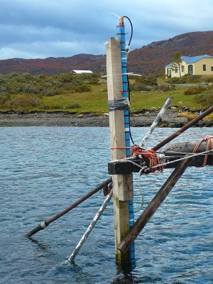
These days the tide sticks are fancier, this is one at Puerto Navarino, southern Chile, in 2009.
View attachment 183498
None of them. The time of 'springs' will be somewhere between them. At that time, the actual tide at that place could be anywhere between HW and LW.Example
Sept 4 and 5 there are three tides with exactly the same ampltude: which would be your "official" spring?
As far as I can see, the almanacs show spring tide to be on the same day at every port around the UK. If the time of springs (which is NOT the same as the time of spring HW) varies from port to port, then sometimes springs would occur on different days at different ports.I don't think it's valid to assume 'the time of spring tide' will be the same everywhere, even if that's a meaningful concept, because for instance the tide passes up the English Channel as a wave and Dover is inherently delayed relative to Plymouth.
???????????If the time of springs (which is NOT the same as the time of spring HW.......
Have a look atAs far as I can see, the almanacs show spring tide to be on the same day at every port around the UK. If the time of springs (which is NOT the same as the time of spring HW) varies from port to port, then sometimes springs would occur on different days at different ports.
All those references are informative, but they do not answer my question of when exactly is a spring tide. In order to measure the age of the tide at a location (i.e. the interval between full/new moon and spring tide at that location), it is necessary to know the time of spring tide at that location. How is this defined? If it is defined as the time of the highest high tide, which tide is chosen when (as often happens) there is more than one successive high tide of the same height? This suggests that it is more likely to be defined as the maximum of the envelope of the tidal curve at that location, which is not necessarily at the same time as a particular high tide.Have a look at
Why don't spring tides occur at full/new moon (age of tide)?.
and
Lunitidal interval - Wikipedia
and
age of phase inequality - NOAA Tides & Currents.
Spring/Neaps are related to amplitude, not levels of single HW or LW. A time series of amplitudes is not a continuous line, giving a local maximum/minimum which you could choose to get your istantaneous hh:mm "time" of springs, it's more like a bar chart with the bars spanning from every LW to HW to LW etc.All those references are informative, but they do not answer my question of when exactly is a spring tide. In order to measure the age of the tide at a location (i.e. the interval between full/new moon and spring tide at that location), it is necessary to know the time of spring tide at that location. How is this defined? If it is defined as the time of the highest high tide, which tide is chosen when (as often happens) there is more than one successive high tide of the same height? This suggests that it is more likely to be defined as the maximum of the envelope of the tidal curve at that location, which is not necessarily at the same time as a particular high tide.