Colvic Watson
Well-known member
We're planning a trip to Stone Point but wondered if you can get in at or near to low water, last time we visited it was dicey.

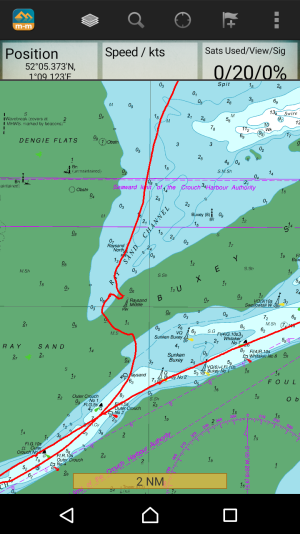
Thanks for your reply. To this day I never under stood why they put a Safe Water Mark in the middle of a drying sand bank. Perhaps you have an explanation ?Moving off the thread topic, but Raysand Middle no longer exists:
View attachment 161915
see also the relevant charlet here:
Downloads
Suspect Roger Gaspar will be along shortly
It's the east coast, anything low enough to not have a permanent snowline is considered deep water.Thanks for your reply. To this day I never under stood why they put a Safe Water Mark in the middle of a drying sand bank. Perhaps you have an explanation ?
Went in and out last week. Just follow the buoys. Lowest depth measured was 0.7m below CD. Stay close to the No.9 buoy.We're planning a trip to Stone Point but wondered if you can get in at or near to low water, last time we visited it was dicey.
It's a better explanation than the positions of the two Spitway buoys. Or it was. By the way, the electronic chart ... hilarious.Thanks for your reply. To this day I never under stood why they put a Safe Water Mark in the middle of a drying sand bank. Perhaps you have an explanation ?
Why not? If you have enough depth it's ok.Back to the OP. Why on earth would you want to go into the Walton Channel on anything but a rising tide?
If I were leaving Ipswich, making use of the free-flow in the lock and the ebb down the Orwell, I might well be arriving at Stone Point at half ebb or later if I’ve stopped for a drink at Halfpenny Pier.Back to the OP. Why on earth would you want to go into the Walton Channel on anything but a rising tide?
Surely the question might be -why would one want to go up there anywayBack to the OP. Why on earth would you want to go into the Walton Channel on anything but a rising tide?