What is the minimum amount of charts and books that I need for going around Scotland?

john_morris_uk

Well-known member
Joined
3 Jul 2002
Messages
27,940
Location
At sea somewhere.
yachtserendipity.wordpress.com
I think his locations are fine. I am not as convinced about his depth contours, which I think are sometimes rather misleading. I don't blame him for that, though. I have spent some of my life plotting contours from irregular data grids - it's a very tricky business which in essence is no more than mathematical guesswork. Since a single shallow bit can be a pinnacle, a reef or a flat plane of rock, errors are inevitable. Moral: measured depths are probably OK but contours are general guidance only and should never be relied on. That goes for UKHO too.
If a UKHO contour is a ‘best estimate’ by the chart compiler it’s shown as a pecked line.
 

dunedin

Well-known member
Joined
3 Feb 2004
Messages
14,082
Location
Boat (over winters in) the Clyde
Visit site
I think his locations are fine. I am not as convinced about his depth contours, which I think are sometimes rather misleading. I don't blame him for that, though. I have spent some of my life plotting contours from irregular data grids - it's a very tricky business which in essence is no more than mathematical guesswork. Since a single shallow bit can be a pinnacle, a reef or a flat plane of rock, errors are inevitable. Moral: measured depths are probably OK but contours are general guidance only and should never be relied on. That goes for UKHO too.

If you read how Antares do their surveys you will see that they are rather more sophisticated than simple spot depths soundings, of the type many old Admiralty Charts are.
 

AntarcticPilot

Well-known member
Joined
4 May 2007
Messages
10,595
Location
Cambridge, UK
www.cooperandyau.co.uk
I think his locations are fine. I am not as convinced about his depth contours, which I think are sometimes rather misleading. I don't blame him for that, though. I have spent some of my life plotting contours from irregular data grids - it's a very tricky business which in essence is no more than mathematical guesswork. Since a single shallow bit can be a pinnacle, a reef or a flat plane of rock, errors are inevitable. Moral: measured depths are probably OK but contours are general guidance only and should never be relied on. That goes for UKHO too.
I too have spent a lot of my career contouring survey data, and JD has it exactly right. Part of the problem is that measurements along survey lines can be especially difficult, resulting in artefacts.

I once had to recommend a complete revision of a paper which had used an automatic contouring routine - they were writing about completely spurious artefacts if the contouring routine!
 

dunedin

Well-known member
Joined
3 Feb 2004
Messages
14,082
Location
Boat (over winters in) the Clyde
Visit site
I too have spent a lot of my career contouring survey data, and JD has it exactly right. Part of the problem is that measurements along survey lines can be especially difficult, resulting in artefacts.

I once had to recommend a complete revision of a paper which had used an automatic contouring routine - they were writing about completely spurious artefacts if the contouring routine!

For those that are interested in the detail, this is what Antares says about how they make the charts - including a second (or more) sweep with side scan sonar, rather than rely on the old Admiralty “survey lines” approach. Making the Charts

Clearly the big boys (commissioned by UKHO) also use side scan sonar these days, but apparently not in shallow water or remote anchorages we yachties tend to frequent.
As ever, caution required amongst rocks whatever sources are used.
 

JumbleDuck

Well-known member
Joined
8 Aug 2013
Messages
24,167
Location
SW Scotland
Visit site
If you read how Antares do their surveys you will see that they are rather more sophisticated than simple spot depths soundings, of the type many old Admiralty Charts are.
Ultimately, it's all spot depths. The trick is in getting them in the right place and yes, I know Bob takes extra readings in the dubious places. The problem then is knowing which are the dubious places ...
 

NormanS

Well-known member
Joined
10 Nov 2008
Messages
9,749
Visit site
That does not surprise me in the least. The HO is really only now interested in surveying parts of the coast which are of commercial interest, and any electronic charts will be based on their very old surveys, where the datum is now unreliable. Soay is definitely not one of these!.

As @AntarticPilot states, situational awareness and navigating by Mk1 eyeball is sometimes more wise.

When the CCC was working on updating the North Coast and Northern Isle pilot to bring it up to uniform standards (this was after Imrays took-over the printing) there were some major problems in standardising the sketch chartlets. We looked at the old charts in the NLS as they contained more information for inshore areas than the current HO charts.

(BTW - there are major portions of 'interesting' places on the west coast of the Shetlands where information is very sketchy, in some places marked as 'unsurveyed'. Any information will be gratefully received to fill in these gaps.)
I have found that the level of interest in inshore minutiae in out of the way places, taken by the HO depends very much on the levels of enthusiasm of the current staff. Over the years, I have reported several "anomalies", and have had a variety of responses, mostly good, but occasionally very poor. The latest one, the report of a shallow rocky patch off Taransay, received a very good response, and is now marked on the current issue of BA Chart 2841,
as a 1m patch, rep 2019.
 

JumbleDuck

Well-known member
Joined
8 Aug 2013
Messages
24,167
Location
SW Scotland
Visit site
It's a full download yearly, though he took a year off recently. I don't know if he was able to get out much in 2020.
There was a 2020 issue but not a 2019 one. Unfortunately he dropped the TIFF versions in so it's now BSB and KMZ only - nothing which can be easily viewed as standalone images.
 

Thresher

Active member
Joined
19 Aug 2002
Messages
225
Location
Tollesbury
Visit site
I have a collection of old CCC books which I used to loan out to visitors, mainly through uk.rec.sailing. If the OP would like one, I can have a look and see what's left. It will be mid-70s at the latest.
Thank you JumbleDuck, that's very kind of you to offer. I have been looking on here and elsewhere for job lots of charts and pilot books. I might get back to you if I don't have any luck but will continue to look for a while.
 

Kelpie

Well-known member
Joined
15 May 2005
Messages
7,767
Location
Afloat
Visit site
There was a 2020 issue but not a 2019 one. Unfortunately he dropped the TIFF versions in so it's now BSB and KMZ only - nothing which can be easily viewed as standalone images.
Oh well in that case I'll have to stop being a luddite and actually install it again!
 

mattonthesea

Well-known member
Joined
28 Nov 2009
Messages
1,403
Location
Bristol
ayearatsea.co.uk
Knowing exactly where you are, or where the plotter thinks you are, is over-rated.
On the way in to Soay harbour, SWMBO held us bang on the leading line as directed in the pilot book. Meanwhile I kept glancing at the plotter and was having kittens because it placed us about 50m to the west, on solid ground. That's the biggest charting/GPS error we've encountered but there have been others where we've been glad to have the pilot book to follow, and not just believe what the plotter told us.
Similar thing going into Santa Marta de Orteguiera on N Spanish coast. No nav marks - you have to do it by eye. Go close to a rock on one side of a gap, over the very shallow sand bar heading towards a shore. Once close to the shore turn right! Calls from below were trying to tell me to turn right on the bar - and towards visible sand!
 

Daydream believer

Well-known member
Joined
6 Oct 2012
Messages
21,284
Location
Southminster, essex
Visit site
I have been round twice via the canal canal starting from the Thames estuary & going along the french coast to the CIs then across to Falmouth up to Milford Haven & across to dun laoghaire, then up to Croabh Haven.
No chart plotter the first time.
I had a detailed chart of the Channel islands, because I go there a lot. Plus , obviously, the Thames estuary. I bought the Imray folio pack for the part from Port Elen to the Cally canal which was useful without the plotter, but not needed with one.
For the rest of the trip I had a set of Imray C series passage charts which were more than enough. ( except Newlyn is not marked & i had to ask someone where it was!!) Somebody gave me a 10 year old detailed chart of the inshore passage round lands end which I found very useful. If going along the S coast i would probably get some detailed charts of that section as I might do it again some day. I am planning another circumnavigation in 2021 if Covid allows it
However, an up to date Reeds is a necessity
I did buy the Imray Irish sea Pilot & one for the west & east coast of Scotland, but they were a waste of money. Roger Oliver's book ( forget title) was well worth the read prior to going & I took that with me for reference from time to time.
I only stopped at marinas, as I never anchor .
 

dunedin

Well-known member
Joined
3 Feb 2004
Messages
14,082
Location
Boat (over winters in) the Clyde
Visit site
...................I bought the Imray folio pack for the part from Port Elen to the Cally canal which was useful without the plotter, but not needed with one. For the rest of the trip I had a set of Imray C series passage charts which were more than enough.
...............
I only stopped at marinas, as I never anchor .
......................

I think these statements are closely related.

As I said in post #3 it does depend a lot on how one plans to go cruising- and each to their own style.

But in my view visiting the Scottish West Coast by marina hopping (and also bypassing most via the Canal) is fine, but a bit like me ”visiting London“ by driving round the M25 - ticks the box but misses all the best bits :)
 

Daydream believer

Well-known member
Joined
6 Oct 2012
Messages
21,284
Location
Southminster, essex
Visit site
OK apologies for being nosy, but... why?
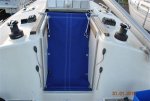
I get hopelessly seasick. I regularly arrive at Bradwell & run onto the mud whilst waiting for the tide in the creek. If I lay down for a kip & the boat tips I get really bad migraine attacks so have to sit on deck. Plus if I were to anchor anywhere near a shore & had to move in a hurry I might well run aground whilst struggling to get the anchor up especially at night. Imagine how dodgy that is for a single handed sailor in rocky anchorages in the west Scotland section north of the Cally canal.
Just not worth the risk.
I have anchored 4 times in 18 years 3 times in emergency & each time I had others to get the anchor up. Under way I sleep on deck in the cockpit hatch area where I have a specially made hammock with my feet in the cockpit area & my head just below the cabin top
Hammock 2 (600 x 403).jpg

This is a terrible thread drift, but to a single handed sailor doing a round UK trip may be of use. I did 6 legs over 100 miles. Plus some night sailing .That means I need to catnap & this allows me to rest for short periods, Then sit up without moving far, Look round, then flop back. Being between 2 sides means I am braced so sleep better. I have a piece of sponge to brace my head It is tied to a line to stop it blowing away.( the sponge, not my head:eek:)
 
Last edited:

NormanS

Well-known member
Joined
10 Nov 2008
Messages
9,749
Visit site
I get hopelessly seasick. I regularly arrive at Bradwell & run onto the mud whilst waiting for the tide in the creek. If I lay down for a kip & the boat tips I get really bad migraine attacks so have to sit on deck. Plus if I were to anchor anywhere near a shore & had to move in a hurry I might well run aground whilst struggling to get the anchor up especially at night. Just not worth the hassle. I have anchored 4 times in 18 years 3 times in emergency & each time I had others to get the anchor up. Under way I sleep on deck in the cockpit hatch area where I have a specially made hammock with my feet in the cockpit area & my head just below the cabin top
View attachment 106427

This is a terrible thread drift, but to a single handed sailor doing a round UK trip may be of use. I did 6 legs over 100 miles. That means I need to catnap & this allows me to rest for short periods, then sit up without movig far, look round then flop back. Being between 2 sides means I am braced so sleep better. I have a piece of sponge to brace my head It is tied to a line to stop it blowing away.( the sponge, not my head:eek:)
In your circumstances you did the right thing. There are no real marinas in the area that you missed.
 
Top