jeksor
New member
Hello sailors,
I am a novice Day Skipper who obtained my license in the summer of 2022.
Currently, my crew and I are planning a sailing trip from Falmouth to the Scilly Isles and back.
I would greatly appreciate your thoughts and feedback on our draft plan.
Any blind spots?
Any poor decisions in the plan?
Any advice or warnings?
What wind force or sea state should we use as a STOP for our strip?
Context:
I eagerly await your feedback and suggestions.
Note 1: In our planning process, we will be utilizing paper charts for passage planning.
However, at the moment, I am referring to resources such as Reeds Almanac and the West Cruising Company by Mark Fishwick, as well as utilizing online charts from Savvy Navvy.
Note 2: I have noticed that Savvy Navvy plots a route with an excessive number of tacks, which seems more complex than I anticipated.
I would appreciate any insight into whether the actual navigation on the water is as intricate as depicted in the software or if it simplifies the process.
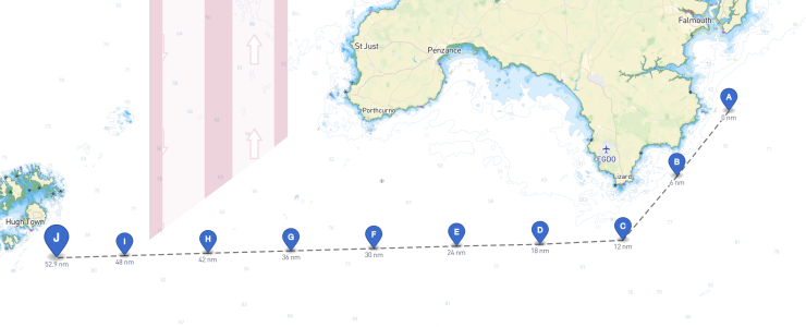
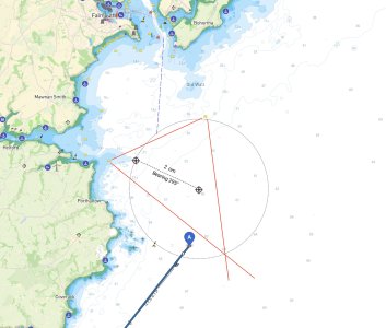
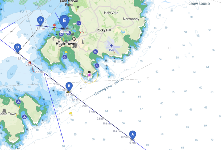
Note 3: I have attached a couple of screenshots with the preliminary routes generated by Savvy Navvy.
I am a novice Day Skipper who obtained my license in the summer of 2022.
Currently, my crew and I are planning a sailing trip from Falmouth to the Scilly Isles and back.
I would greatly appreciate your thoughts and feedback on our draft plan.
Any blind spots?
Any poor decisions in the plan?
Any advice or warnings?
What wind force or sea state should we use as a STOP for our strip?
Context:
- Skipper's Experience
- I have 10 days of sailing experience, including several hours of night sailing.
- Crew
- We have a crew of 8 people, with 3 of us being day skippers with similar levels of experience. The remaining members have sailed as crew on a few occasions before.
- Dates
- We plan to depart from Falmouth on July 15th and return on July 18th.
- Boat
- We will be sailing on a Bavaria 38, a 2003 model with a length overall (LOA) of 11.85 meters, a draft of 1.85 meters, and a 29-horsepower engine.
- The fuel capacity is 150 litres, and the water capacity is 370 litres.
- We have rented the boat from BOWMAN YACHT CHARTERS.
- Arrival and Preparation:
- On the evening of July 14th, the crew will arrive in Falmouth to stock provisions, familiarize ourselves with the boat, and finalize the planning.
- Departure:
- If weather conditions permit, we intend to slip off Falmouth Marina at 6 a.m. on July 15th (it's earlier, but we want to practice a bit, before heading to the open water)
- By 7 a.m., we expect to reach the exit of Falmouth Marina.
- Training:
- We plan to spend approximately 1-hour practising tacking, jibing, MOB (man overboard) drills, and reefing in the vicinity of 50° 04.810' N 05° 01.246' W (hope the traffic won't be a problem, it's about 2nm NE to Manacles E cardinal)
- Timing and Course:
- By 8 a.m. (high water at Dover -0230), we aim to be east of Manacle BYB, taking advantage of 4 hours of favourable tides.
- Our intended course is to stay 3 nautical miles south of Lizard Point and head in a direction of 270° towards the Scilly Isles (St. Mary's Sound entrance)
- The journey from this point to St. Mary's Sound is approximately 66 nautical miles, which, at an average speed of 6 knots, should take around 12-13 hours.
- Upon approaching St. Mary's Sound, we plan to enter the transit 307°, 3 nautical miles southeast of Spanish Ledge.
- Arrival at St. Mary's:
- By 8 p.m., we expect to reach the entrance of St. Mary's Sound, using the recommended transits. It is approximately 4 nautical miles to St. Mary's Harbour from there.
- We anticipate arriving at St. Mary's Harbour by 9 p.m., where we will either moor or anchor. If strong gales from the west or northwest are forecasted, we may consider using Porth Cressa instead.
- Regarding the wind force or sea state that would prompt us to stop the trip, we will closely monitor the forecast.
If the wind forecast indicates below 15 knots with gusts up to 25 knots and good visibility, we consider the passage safe and feasible.
However, if conditions are unfavourable, we will opt for an alternative route to Penzance or stay in the vicinity of Falmouth.
Is it too cautious?
- I do have concerns that the direct passage of 66 nautical miles may be too exhausting for the crew.
Should we consider splitting the passage and spending a night at Newlyn or Penzance? However, this would significantly reduce our time on the Scilly Isles.
I wonder if it is overly optimistic to assume that our novice crew and the chosen boat will be able to maintain an average speed of 6 knots throughout the journey to the Scilly Isles.
- Arriving at St. Mary's Harbour around 9 pm would be 5 hours after HW.
It is generally considered advantageous as we can have better visibility of rocks, is it?
I eagerly await your feedback and suggestions.
Note 1: In our planning process, we will be utilizing paper charts for passage planning.
However, at the moment, I am referring to resources such as Reeds Almanac and the West Cruising Company by Mark Fishwick, as well as utilizing online charts from Savvy Navvy.
Note 2: I have noticed that Savvy Navvy plots a route with an excessive number of tacks, which seems more complex than I anticipated.
I would appreciate any insight into whether the actual navigation on the water is as intricate as depicted in the software or if it simplifies the process.
Note 3: I have attached a couple of screenshots with the preliminary routes generated by Savvy Navvy.


