Rule of 12ths, how accurate is it?

Gwylan

Well-known member
Joined
31 May 2007
Messages
3,651
Location
Moved ashore
Visit site
With the vagueness of tide charts modified by pressure and wind and the availability of tidal graphs - how dependable is the rule of 12ths?

We beach quite often and I use the rule of 12ths (came off a beach at noon (hence the question), its easy - but I am cautious.

Am I showing my age? Is there a better way.

Jonathan
It's BPF [ball park figure] or horse-back arithmetic.
Gives you an idea, but the whole algorithm is just that and no substitute for local observation and interpolation.

For interpolation you need a model to interpret and a data set to deploy. Some numerical analysis experience would help. Probably run out of time before you get the answer.

Or you accept that it will be +- 15 mins and get on with life.

Ask the Bristol Channel chaps where the tide moves at 5 knots and depth changes at 2m per hour - then you need to do your sums
 

Richard10002

Well-known member
Joined
17 Mar 2006
Messages
18,979
Location
Manchester
Visit site
The high tide yesterday was 1.93m, today 1.83m and tomorrow 1.7m.

So to ensure I could float of tomorrow - what allowance should I haver made - to dry out yesterday and float off tomorrow.

I confess I chickened out (hence the thread) I calculated for tomorrow - and came off today (without issue). If I had got it wrong and stayed, or better put stayed and tried to come off tomorrow - I'd have to wait a month if I cocked it up.


I don't think "chickened out" is a fair description of what you did.

If you are reasonably certain you can do something one day, but not very sure that you could do it the next, and given the downside of a cock up, you did exactly the right thing.
 

Old Bumbulum

Well-known member
Joined
11 May 2018
Messages
1,112
Visit site
Rule of twelfths is more than accurate enough for leisure yachting. The fixation today with 'accuracy' has become an an obsession, that overrules considering how much accuracy you actually need.
What's the point of a plotter that tells you a course to a tenth of a degree when neither you nor the autopilot can steer a course accurately better than three or four degrees? What's the point of a tide prediction that tells you the tide height to millimetres when you have no idea of true height over datum to wthin a foot or more even in good weather due to wind, pressure etc, and beyond that have no idea how much the bottom has changed since the last survey? What's the point of knowing the boatspeed to a tenth of a knot when you have no real idea of the tidal stream to better than probably half a knot? What is the point of a GPS that tells you your position mid-atlantic to within o metres when even a clumsy astral fix puts you within 3-4 miles? You ain't going to miss Bermuda with that, are you? So how does a 3m accuracy satnav improve matters? It doesn't , it's complete overkill - in that situation.
Equally you wouldn't try to find Yarmouth harbour by astral in fog , would you? When satnav might just be a big help?

Horses for courses. Use the easiest system that gives you enough accuracy to be useful, but not so much that it obscures what you wanted to do in the first place. It's no more than simple common sense.

If not duffers wont drown....
 

Elessar

Well-known member
Joined
10 Jul 2003
Messages
9,995
Location
River Hamble
Visit site
Rule of twelfths is more than accurate enough for leisure yachting. The fixation today with 'accuracy' has become an an obsession, that overrules considering how much accuracy you actually need.
What's the point of a plotter that tells you a course to a tenth of a degree when neither you nor the autopilot can steer a course accurately better than three or four degrees? What's the point of a tide prediction that tells you the tide height to millimetres when you have no idea of true height over datum to wthin a foot or more even in good weather due to wind, pressure etc, and beyond that have no idea how much the bottom has changed since the last survey? What's the point of knowing the boatspeed to a tenth of a knot when you have no real idea of the tidal stream to better than probably half a knot? What is the point of a GPS that tells you your position mid-atlantic to within o metres when even a clumsy astral fix puts you within 3-4 miles? You ain't going to miss Bermuda with that, are you? So how does a 3m accuracy satnav improve matters? It doesn't , it's complete overkill - in that situation.
Equally you wouldn't try to find Yarmouth harbour by astral in fog , would you? When satnav might just be a big help?

Horses for courses. Use the easiest system that gives you enough accuracy to be useful, but not so much that it obscures what you wanted to do in the first place. It's no more than simple common sense.

If not duffers wont drown....
Yep.
You make a good point about accuracy in both depth and position.
Take data recorded by men in rowing boats with lead lines.
Put it on a swanky map.
Send it to a woman in the mountains in Italy. She’s on minimum wage and never seen a boat.
She makes it “digital” and it’s put in a little chip.
We but the data for £00’s and put it into a machine costing £,000s
It’s displayed in 3D on a swanky screen. We can use the screen to steer our boat - even those with 2 commas in their price tag - and expect to miss things.
What would the bloke in the rowing boat think??
 

LittleSister

Well-known member
Joined
12 Nov 2007
Messages
18,437
Location
Me Norfolk/Suffolk border - Boat Deben & Southwold
Visit site
The fixation today with 'accuracy' has become an an obsession, that overrules considering how much accuracy you actually need.
. . .
Horses for courses. Use the easiest system that gives you enough accuracy to be useful, but not so much that it obscures what you wanted to do in the first place.

Exactly so!

This obsession seems to infect all sorts of areas of life these days, well beyond sailing, to the point where it seems often to detract from, or perhaps even prevent, achievement of the point of the activity.

It's no more than simple common sense.

If only common sense were more common!
 

Neeves

Well-known member
Joined
20 Nov 2011
Messages
12,855
Location
Sydney, Australia.
Visit site
We entirely agree with Bumblebum (and Little Sister and Zoidberg) and switch our chart plotter off when crossing oceans or seas and simply have it on for enough time to record the lat and long twice a day along with boat speed (we keep the log on) as it gives distance travelled (accepting currents might introduce errors) and we would use the, magnetic, compass. When sailing down the New South Wales coast we keep the chart plotter on as we follow the 100 fathom line - as it puts us into the East Australian Current (which is warm and can move at 4 knots, quite a lift going South) and we can confirm we are in the current by simply watching the temperature of the water (which is warmer than the water adjacent to the coast). Horses for courses. I would qualify - switching off the chart plotter is strongly motived by saving power!

Thanks for all the comments

We will stick with the rule of 12ths and a healthy dose of caution. I like the concept as there are, roughly, 6 hrs between high and low - which fits nicely with the 12th (less convenient if it was metricated). I work on 1/12th, 2/12th and 3/12ths for the 3 hours to mid tide etc. Its simple and appeals to my preference to keep life simple.

To elaborate slightly - the bay in which we dry out is well known to us and has a sand bottom. The sand is washed down from the sandstone bedrock by a rather (currently) paltry stream. But its going to rain, forecast is 25mm in the next 3 days The sand does move, there were some odd conical lumps yesterday that I had not seen before. But as long as its sand we are more than happy with a depth under our mini keels of a few centimetres (or if we are drying out - nothing under the keels (except sand). If we dry out and the tide does not quite float us off - it does not matter if we miss the tide by a couple of cm or 30cm - we are stuck there (until the next higher tide (one month away).

Being, overly, cautious - we have not been stuck, yet, and we intend it remains so.

And the whys - we can wipe down the hulls and props and clean the top sides. We check the anodes. The alternative is swimming, and I never find trying to clean the hull when swimming very satisfactory (and very hard work) or slipping - which costs an inordinate amount. As fouling is more frequent in the summer our visits to the bay increase in frequency to once every 2 months. over the winter - maybe once every 4 months. Careening used to be quite popular, with associated poles and grid - I think the environmental lobby has strangled that


For those with good memories (and this has nothing to do with the Rule of 12ths).

The bay accommodates a rather attractive Government house built out of local sandstone and enjoys a pool., now (the house) used by National Parks (the pool is empty). Historically (40/50 years ago) it was used by a Prime Minister as a retreat. Its main claim to fame is that it was the location to hide the Petrovs when Mr Petrov decided to seek political asylum in Australia. Mrs Petrov was whisked away and flown out of Australia by the Russians but the plane was a forced to land in Darwin, not sure how they forced it down. Mr and Mrs were re-united and were hidden in the house, access is only by water - the rest is impenetrable bush. Once the brouhaha died down the Petrovs lived comfortably in Melbourne (or I assume comfortably). For the salacious details - Mr Google has no prejudices.

Jonathan
 

Uricanejack

Well-known member
Joined
22 Oct 2012
Messages
3,750
Visit site
I\ve highlighted a part in red ... c'mon - you know that that's not strictly correct. Official tide tables use a factor calculated for a particular location which alters the interpolation to try and mimic the curve at that location. HMSO Tide Tables have a whole section devoted to this at back of the book. As well as the curve at first page of location ... giving the predicted rate of tide at each time interval.
To say it’s just a sine wave is certainly over simplified. Still it’s an approximation.
Personally I don’t use rule of 12ths, if I’m going to bother figuring out the tide. I might as well just use the tables. Range and duration are often not equal on both sides of the curve, if the tides were 6 or 12 hours, we wouldn’t need predictions. Besides islands round here bugger it up anyways.

The question here, is it good enough? Depends?
 

LittleSister

Well-known member
Joined
12 Nov 2007
Messages
18,437
Location
Me Norfolk/Suffolk border - Boat Deben & Southwold
Visit site
Mrs Petrov was whisked away and flown out of Australia by the Russians but the plane was a forced to land in Darwin, not sure how they forced it down.

They didn't force it down, it seems -
"when the aircraft stopped for refuelling at Darwin Airport, she was seized from the MVD men by ASIO officials. (In order to separate Petrova from the MVD, the ASIO officials confronted them on the grounds that they were carrying arms, which it was illegal to do on an aircraft.)"
Petrov Affair - Wikipedia
 

hrchivers

Member
Joined
13 Nov 2008
Messages
99
Visit site
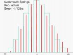
It may help to see what happens when the tide is not a nice sinusoid. The attached picture is for Avonmouth, which is not extreme but already significant - only 10 miles further North the tide takes 4 hours to come in and 8 to go out. 12ths are good, but it pays to know if the tides are well behaved. Avonmouth tides.jpg
 

Redfox226

Member
Joined
7 Aug 2012
Messages
206
Location
Me: Wakefield; Boat: Gibraltar Point SC
Visit site
Surely, Neeves, if you dry out at Half tide, you'll float at half tide, and at 2/3 high tide, you'll float at 2/3 low tide - or am I completely befuddled?
I.E. if you dry out at 3hr before high tide, you'll float at approx 3hr after high tide, and if you dry out at HT - 3hr, you'll float at approx HT +3hr -I stand to be corrected.......
 

Roberto

Well-known member
Joined
20 Jul 2001
Messages
5,290
Location
Lorient/Paris
sybrancaleone.blogspot.com
Surely, Neeves, if you dry out at Half tide, you'll float at half tide, and at 2/3 high tide, you'll float at 2/3 low tide - or am I completely befuddled?
I.E. if you dry out at 3hr before high tide, you'll float at approx 3hr after high tide, and if you dry out at HT - 3hr, you'll float at approx HT +3hr -I stand to be corrected.......
Not in general.
Even supposing perfectly sinusoidal curves, in a lot of places with semidiurnal tide types, the tiny non-semidiurnal components will make HW/LW different with the same range, and/or a change in range will not reflect a change in absolute HW/LW levels.
Example, you may dry at half tide on a X tidal range day, if the following day you have a greater amplitude, you may float earlier or you may float later, likewise if range is lower.
 

Redfox226

Member
Joined
7 Aug 2012
Messages
206
Location
Me: Wakefield; Boat: Gibraltar Point SC
Visit site
Even supposing perfectly sinusoidal curves, in a lot of places with semidiurnal tide types, the tiny non-semidiurnal components will make HW/LW different with the same range, and/or a change in range will not reflect a change in absolute HW/LW levels.
Sorry, Roberto, I was assuming (silly, I know) drying out and refloating on the same tide cycle........
 

Roberto

Well-known member
Joined
20 Jul 2001
Messages
5,290
Location
Lorient/Paris
sybrancaleone.blogspot.com
Sorry, Roberto, I was assuming (silly, I know) drying out and refloating on the same tide cycle........
Hello RedFox cheers :) ,
I was just sharing the experience of a number of people here in France (I am sure you know the "tidal coefficient" habit, a number which is only related to range, not to absolute HW/LW levels); many marina people will award places following the daily "coefficient", but if brushing the edges one may well get stuck as a next day higher coefficient (higher range) can yield a lower HW (and of course proportionnally lower LW).
Here it can usually be settled by a night leave (anyway, 12 hour difference), as the two daily tidal cycles may have very similar range but different absolute HW/LW levels.

r.
 

Neeves

Well-known member
Joined
20 Nov 2011
Messages
12,855
Location
Sydney, Australia.
Visit site
Surely, Neeves, if you dry out at Half tide, you'll float at half tide, and at 2/3 high tide, you'll float at 2/3 low tide - or am I completely befuddled?
I.E. if you dry out at 3hr before high tide, you'll float at approx 3hr after high tide, and if you dry out at HT - 3hr, you'll float at approx HT +3hr -I stand to be corrected.......

As mentioned, yes and no!

Specifically on the 15th Jan high tide was 1.83m at 1238, the next high tide (about 12hrs later) was 1.46m (at 0129hrs) on the 16th and the following high tide 1.70m again the 16th and 1.56 at 1430 on the 17th (the intermediate high tide is 1.48m)

So if I beach at high tide on the 15th I cannot float off, for roughly a month.

So the question was what calculation method should I use to beach on the 15th, a high tide of 1.83m) and float off comfortably on the 17th with a high tide of 1.56m (with a critical difference of 0.27m (call it 30cm).

Or put another way - how do I set my timing that I beach when the tide is at 1.56m on the 15th - and then I will float of at full high tide on the 17th (and I would introduce some caution once I have the answer.

If I beach at half tide its easy - but I want to have maximum time on the beach to compete the tasks I have set so I aim for near high tide as this gives me a maximum time allocation.


Sometimes the first and second high tides are 'more' similar and as we still want to maximise time we might stay in situ until a following tide (which if we plan correctly is higher than the high tide on which we beach). We then need to beach going astern (because its easier to float off going ahead) and set an anchor off the bow and 2 anchors off each transom - to hold us steady (usually overnight).

This actually raises another question - what lights should be displayed for a yacht that is beached and surrounded by water?

Jonathan
 

LittleSister

Well-known member
Joined
12 Nov 2007
Messages
18,437
Location
Me Norfolk/Suffolk border - Boat Deben & Southwold
Visit site
So if I beach at high tide on the 15th I cannot float off, for roughly a month.

I'd call that 'getting neaped'.

This actually raises another question - what lights should be displayed for a yacht that is beached and surrounded by water?

Normal anchor light(s), plus 2 all round reds one above the other.
Daymark is three, er, balls up (in a vertical line).
 

Kawasaki

Well-known member
Joined
21 Jun 2004
Messages
11,728
Location
Anglesey Wales
Visit site
Rule of twelfths is more than accurate enough for leisure yachting. The fixation today with 'accuracy' has become an an obsession, that overrules considering how much accuracy you actually need.
What's the point of a plotter that tells you a course to a tenth of a degree when neither you nor the autopilot can steer a course accurately better than three or four degrees? What's the point of a tide prediction that tells you the tide height to millimetres when you have no idea of true height over datum to wthin a foot or more even in good weather due to wind, pressure etc, and beyond that have no idea how much the bottom has changed since the last survey? What's the point of knowing the boatspeed to a tenth of a knot when you have no real idea of the tidal stream to better than probably half a knot? What is the point of a GPS that tells you your position mid-atlantic to within o metres when even a clumsy astral fix puts you within 3-4 miles? You ain't going to miss Bermuda with that, are you? So how does a 3m accuracy satnav improve matters? It doesn't , it's complete overkill - in that situation.
Equally you wouldn't try to find Yarmouth harbour by astral in fog , would you? When satnav might just be a big help?

Horses for courses. Use the easiest system that gives you enough accuracy to be useful, but not so much that it obscures what you wanted to do in the first place. It's no more than simple common sense.

If not duffers wont drown....
Spot on OB
 
Top