tillergirl
Well-known member
Another classic blunder by Navionics. And I also admit a collosal blunder by me - I bought a Navionics card last week! Me, yes. I'm sorry. 
Can I list the current errors with last week's chart or app:
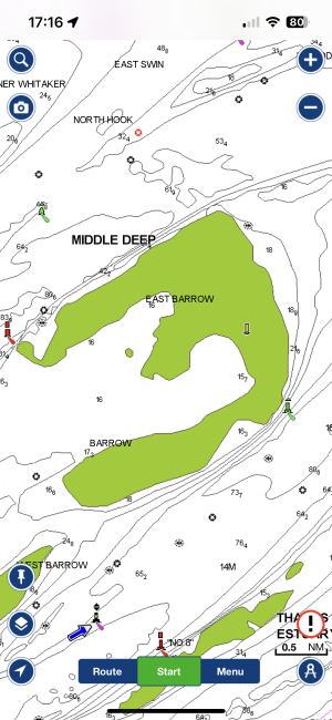
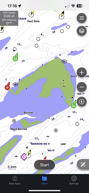
The Buxey Beacon has been moved by someone to the position of the current location of the Ray North yellow special buoy. Somebody yesterday has added the Ray North in the right position - that's well done. I think that might be the yacht that went round the buoy yesterday. Perhaps that yacht has the app.
The Ray Sand is STILL shown in the old position
The Ray Middle red and white has been permanently removed by the CHA but Navionics show the red and white buoy in the current position of the Ray Sand - which is yellow
A user has added another position of the Ray Middle sort of west of where the Ray Sand is currently location.
A user has added a North cardinal beacon! adjacent to the Sunken Buxey North Cardinal buoy
The Ray North red and white buoy is still shown in its old position.
The contours - oh dear. I have a old Navionics card from 2019 as well - Yes I admit it but it is on my Humminbird and all I need on that is a general approximation. Whoops, not even a general approximation in 2019 and whoops todays contours have been changed which I reckon is back to 2010! I admit I am guessing but I first drew the Ray Sand in 2011 and what is today on Navionics is certainly antient.
 P1090744 by Roger Gaspar, on Flickr
I grabbed my camera yesterday and you can see 'Osprey's' (very sensible track). She went round the Ray North buoy so you can see Navionics' blunder before she headed for the 1 degree meridian. See the positons shown of the red and white buoys which don't exist! Note the collosal blunder of the contours supposely drying north of the Buxey Beacon! That is quite wrong.
I admit my tracks are a little odd on the chart - I was just trying to answer the question whether there are just peaks rather than a ridge (there is a 'ridge')
Can I suggest you ignore Navionics. Perhaps someone will do it properly. In the meantime can suggest you download the CTTE chartlet - its FREE. V2 is currently shown but a V3 will be added later this afternoon.
V3 now added: Downloads
Can I list the current errors with last week's chart or app:
The Buxey Beacon has been moved by someone to the position of the current location of the Ray North yellow special buoy. Somebody yesterday has added the Ray North in the right position - that's well done. I think that might be the yacht that went round the buoy yesterday. Perhaps that yacht has the app.
The Ray Sand is STILL shown in the old position
The Ray Middle red and white has been permanently removed by the CHA but Navionics show the red and white buoy in the current position of the Ray Sand - which is yellow
A user has added another position of the Ray Middle sort of west of where the Ray Sand is currently location.
A user has added a North cardinal beacon! adjacent to the Sunken Buxey North Cardinal buoy
The Ray North red and white buoy is still shown in its old position.
The contours - oh dear. I have a old Navionics card from 2019 as well - Yes I admit it but it is on my Humminbird and all I need on that is a general approximation. Whoops, not even a general approximation in 2019 and whoops todays contours have been changed which I reckon is back to 2010! I admit I am guessing but I first drew the Ray Sand in 2011 and what is today on Navionics is certainly antient.
P1090744 by Roger Gaspar, on FlickrI grabbed my camera yesterday and you can see 'Osprey's' (very sensible track). She went round the Ray North buoy so you can see Navionics' blunder before she headed for the 1 degree meridian. See the positons shown of the red and white buoys which don't exist! Note the collosal blunder of the contours supposely drying north of the Buxey Beacon! That is quite wrong.
I admit my tracks are a little odd on the chart - I was just trying to answer the question whether there are just peaks rather than a ridge (there is a 'ridge')
Can I suggest you ignore Navionics. Perhaps someone will do it properly. In the meantime can suggest you download the CTTE chartlet - its FREE. V2 is currently shown but a V3 will be added later this afternoon.
V3 now added: Downloads
Last edited: