Mobile Grib

Refueler

Well-known member
Joined
13 Sep 2008
Messages
20,739
Location
Far away from hooray henrys
Visit site
👍
THis is so common, oh but my favourite app is better than the others. No it's not it's the same data. Plus with the massive human conformation bias we all are prone to you don't know it's better, you see what you want to see & doing any kind of accurate actual against forecast is extremely difficult or actually probably close to impossible for pretty much everyone on here. But doubt that will make any difference to your certainty..🤔😉
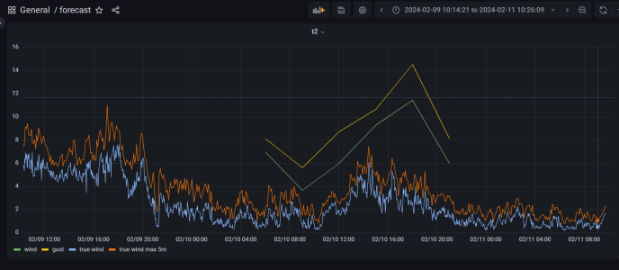
Though I am in the middle of writing some node red which will get gfs data from openweathermap & graph it against what's happening at the masthead... Which should be interesting.

What is interesting..... On the Wind Sailing - Elliot Rappaport // Reading the Glass
Just started the book , great so far 😎

Very funny .... not.

Regardless of same data source or otherwise - weather forecasting still comes down to human interpretation at its final set. All the computers in the world cannot predict all .. so the weather forecaster uses their experience and understanding of patterns / historical data to get to the final forecast.

Remember the infamous Hurricane along the South Coast of UK ?

My trust revolves around observation vs forecasted ... if they agree to a high degree repeatedly - why should I not cautiously believe ?

Don't forget as well that as an ex Ships Officer - I spent many years interpreting sea states / weather etc. Spent many classes for my Tickets studying Met ..

If you think I cannot gauge a forecast against what i see .... then there's no hope for anyone !! Get real !!
 

GHA

Well-known member
Joined
26 Jun 2013
Messages
12,517
Location
Hopefully somewhere warm
Visit site
If you think I cannot gauge a forecast against what i see .... then there's no hope for anyone !! Get real !!
yep. Exactly. Very real, you can't. several centuries since the enlightenment figured this out, get reliable data & compare. . If you could you would have Tb of data to share. Without data you're just another textbook conformation bias example. Robust reaction to having your deep down in the brain beliefs challenged, textbook symptom. And your memory is really pretty useless, if you are relying on memory then not even past the first fence..

Get real. 🤣🤣🤣🤣
 
Last edited:

Refueler

Well-known member
Joined
13 Sep 2008
Messages
20,739
Location
Far away from hooray henrys
Visit site
yep. Exactly. Very real, you can't. several centuries since the enlightenment figured this out, get reliable data & compare. . If you could you would have Tb of data to share. Without data you're just another textbook conformation bias example. Robust reaction to having your deep down in the brain beliefs challenged, textbook symptom.

Get real. 🤣🤣🤣🤣

So if I read a forecast and it says it will rain this afternoon .. wind will be xx m/s and that is what happens ... you telling me that is not what I will see and understand ?

Did I say I WILL forecast the weather ? No I did not. It appears that you are mis-interpreting completely.

I said I will compare the forecast provided by whatever service to what actually happens and decide if I want to use that service or not. If that service provides a good degree of forecasting - confirmed by what actually happens - then I will use it as my usual means to find out weather next days ..

What I can do though - with all the years of sailing the oceans - I have a pretty good idea of when a front is approaching as example. But that's another matter ...
 

franksingleton

Well-known member
Joined
27 Oct 2002
Messages
3,651
Location
UK when not sailing
weather.mailasail.com
Very funny .... not.

Regardless of same data source or otherwise - weather forecasting still comes down to human interpretation at its final set. All the computers in the world cannot predict all .. so the weather forecaster uses their experience and understanding of patterns / historical data to get to the final forecast.
Not so these days. When I did my last shift at Bracknell, we were still in an era when the human could add value. That is barely true now. Forecasters are rightly using model almost entirely. At times they will realise that models are differing slightly - and say so. If you listen to forecasters on TV, that is quite clear.
Remember the infamous Hurricane along the South Coast of UK ?
That was 1987, 9 computers ago. It is a totally different world now.
My trust revolves around observation vs forecasted ... if they agree to a high degree repeatedly - why should I not cautiously believe ?

For the weather now, YES. On many occasions NO for the weather in a few hours time.
Don't forget as well that as an ex Ships Officer - I spent many years interpreting sea states / weather etc. Spent many classes for my Tickets studying Met ..

If you think I cannot gauge a forecast against what i see .... then there's no hope for anyone !! Get real !!

Don’t forget that I am a former (very) Met Office Senior forecaster. I do not doubt your sea going experience. I have a high regard for merchant service captains. I worked with them in the long gone past when the Met Office offered a weather routeing service - that ceased many years ago now -1980s. In my later years I had several retired captains in my directorate.

As regards statements about accuracy, all such statements, including yours, are highly subjective and usually biased by our selective memories. In any case, all such forecasts, WindGuru among them regurgitate the GFS, most often or some other model. All models use the same equations. All official models use the same data. Private organisations that run models never have anywhere near as much data when it comes to detailed forecasts. As Antarctic Pilot said, processing the data nowadays is a massive job needing as much computer effort as running the forecast.

As ever, a thread soon departs from the OP where I asked a specific question about MobileGrib - does it still exist. I also asked if anyone knew about any other GRIB packages similar to the ones that I listed.
 

GHA

Well-known member
Joined
26 Jun 2013
Messages
12,517
Location
Hopefully somewhere warm
Visit site
As ever, a thread soon departs from the OP where I asked a specific question about MobileGrib - does it still exist. I also asked if anyone knew about any other GRIB packages similar to the ones that I listed.
Sorry, mea culpa, I should know better!! 🤣

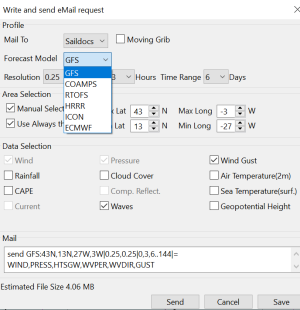
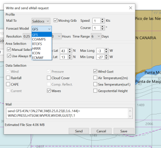
Re Opencpn, these are the options it gives, all it does is create email text. If there's an email program installed then it will create a new email with that text then you click to send it. There is an option for zygrib instead of saildocs but it says "zygribs has momentarily stopped that service. "

The moving grib can be useful offshore, give it a course & speed and it will change the lat & longs to keep the same size but slightly different position.
1707646574301.png
 

Attachments

  • 1707645209024.png
    1707645209024.png
    43 KB · Views: 6

franksingleton

Well-known member
Joined
27 Oct 2002
Messages
3,651
Location
UK when not sailing
weather.mailasail.com
Sorry, mea culpa, I should know better!! 🤣

Re Opencpn, these are the options it gives, all it does is create email text. If there's an email program installed then it will create a new email with that text then you click to send it. There is an option for zygrib instead of saildocs but it says "zygribs has momentarily stopped that service. "

The moving grib can be useful offshore, give it a course & speed and it will change the lat & longs to keep the same size but slightly different position.
View attachment 172154
Thank you for the info on OpenCPN. Their message request seems a direct copy of a Saildocs request. XyGrib is no more 9r, at least, pickled. XyGrib is a fork of zjBrib and greatly expanded.
 
  • Like
Reactions: GHA

GHA

Well-known member
Joined
26 Jun 2013
Messages
12,517
Location
Hopefully somewhere warm
Visit site
And this is interesting..
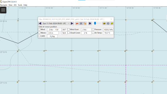
With a grib downloaded from xygrib or opencpn/saildocs, the data points are every 1/4 degree, sort of as you would expect?

1707648027820.png


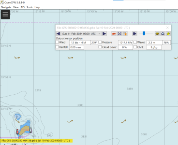
But load a grib downloaded on pocketgrib on the mobile phone and looks like data points are every 0.5Deg & seem to be placed offset from the lat/long lines..

1707647937844.png


Would any of us actually notice if it's offset by a load of miles though. Most here would just look up and see that obviously "told you mine was best" 🤣
 

franksingleton

Well-known member
Joined
27 Oct 2002
Messages
3,651
Location
UK when not sailing
weather.mailasail.com
I do not know how you make that assumption about PG. One of my complaints about GRIB software is that they interpolate between grid points. XyGrib is the only one that I know which has the facility of displaying data ONLY at output grid points. Few people seem to appreciate that all models filter out or smooth small detail and effective resolution is 5 x the computational grid. That is the main reason that models invariably underpredict the strongest winds and do not show the holes that we fall into.
 

GHA

Well-known member
Joined
26 Jun 2013
Messages
12,517
Location
Hopefully somewhere warm
Visit site
I do not know how you make that assumption about PG. One of my complaints about GRIB software is that they interpolate between grid points. XyGrib is the only one that I know which has the facility of displaying data ONLY at output grid points. Few people seem to appreciate that all models filter out or smooth small detail and effective resolution is 5 x the computational grid. That is the main reason that models invariably underpredict the strongest winds and do not show the holes that we fall into.
Not really an assumption, that's what both opencpn and xygrib display with a file created by PG. The opencpn grib plugin seems to just display the datapoints when set to "spacing - minimum". Matches the same grib in xygrib if it has numerical data interpolation turned off.
And very much agree with the rest, these days just look at the datapoints to drum it home that the actual resolution of the data is not the pretty colours some software has added. 👍
Would be interesting to get at the data inside the pocketgrib grib file to have a look. Not come across anything that doe that so probably a python job.
 

GHA

Well-known member
Joined
26 Jun 2013
Messages
12,517
Location
Hopefully somewhere warm
Visit site
No idea if this helps at all as to why the pocketgrib file was displayed with datapoints not on the lat long you would expect, no idea what this means 😁
But got in there which is cool. Forgot gribs don't tell you wind speed & direction but velocity in N/S & E/W directions.

xarray.Dataset
  • Dimensions:
    • step: 33
    • latitude: 61
    • longitude: 39
  • Coordinates:
    • time
      ()
      datetime64[ns]
      ...
    • step
      (step)
      timedelta64[ns]
      0 days 00:00:00 ... 4 days 00:00:00
    • meanSea
      ()
      float64
      ...
    • latitude
      (latitude)
      float64
      17.0 17.5 18.0 ... 46.0 46.5 47.0
    • longitude
      (longitude)
      float64
      -24.0 -23.49 ... -5.257 -4.75
    • valid_time
      (step)
      datetime64[ns]
      ...
    • heightAboveGround
      ()
      float64
      ...
    • surface
      ()
      float64
      ...
    • entireAtmosphere
      ()
      float64
      ...
  • Data variables:
    • msl
      (step, latitude, longitude)
      float32
      ...
    • u10
      (step, latitude, longitude)
      float32
      ...
    • v10
      (step, latitude, longitude)
      float32
      ...
    • p3059
      (step, latitude, longitude)
      float32
      ...
    • tcc
      (step, latitude, longitude)
      float32
      ...
    • p3100
      (step, latitude, longitude)
      float32
      ...
    • p3101
      (step, latitude, longitude)
      float32
      ...
    • p3103
      (step, latitude, longitude)
      float32
      ...
    • unknown
      (step, latitude, longitude)
      float32
      ...
  • Indexes: (3)

  • Attributes:

    GRIB_edition :1GRIB_centre :kwbcGRIB_centreDescription :US National Weather Service - NCEPGRIB_subCentre :0Conventions :CF-1.7institution :US National Weather Service - NCEPhistory :2024-02-11T18:51 GRIB to CDM+CF via cfgrib-0.9.10.4/ecCodes-2.26.0 with {"source": "gfs.grb", "filter_by_keys": {}, "encode_cf": ["parameter", "time", "geography", "vertical"]}
 

franksingleton

Well-known member
Joined
27 Oct 2002
Messages
3,651
Location
UK when not sailing
weather.mailasail.com
No idea if this helps at all as to why the pocketgrib file was displayed with datapoints not on the lat long you would expect, no idea what this means 😁
But got in there which is cool. Forgot gribs don't tell you wind speed & direction but velocity in N/S & E/W directions.

xarray.Dataset
  • Dimensions:
    • step: 33
    • latitude: 61
    • longitude: 39
  • Coordinates:
    • time
      ()
      datetime64[ns]
      ...
    • step
      (step)
      timedelta64[ns]
      0 days 00:00:00 ... 4 days 00:00:00
    • meanSea
      ()
      float64
      ...
    • latitude
      (latitude)
      float64
      17.0 17.5 18.0 ... 46.0 46.5 47.0
    • longitude
      (longitude)
      float64
      -24.0 -23.49 ... -5.257 -4.75
    • valid_time
      (step)
      datetime64[ns]
      ...
    • heightAboveGround
      ()
      float64
      ...
    • surface
      ()
      float64
      ...
    • entireAtmosphere
      ()
      float64
      ...
  • Data variables:
    • msl
      (step, latitude, longitude)
      float32
      ...
    • u10
      (step, latitude, longitude)
      float32
      ...
    • v10
      (step, latitude, longitude)
      float32
      ...
    • p3059
      (step, latitude, longitude)
      float32
      ...
    • tcc
      (step, latitude, longitude)
      float32
      ...
    • p3100
      (step, latitude, longitude)
      float32
      ...
    • p3101
      (step, latitude, longitude)
      float32
      ...
    • p3103
      (step, latitude, longitude)
      float32
      ...
    • unknown
      (step, latitude, longitude)
      float32
      ...
  • Indexes: (3)

  • Attributes:

    GRIB_edition :1GRIB_centre :kwbcGRIB_centreDescription :US National Weather Service - NCEPGRIB_subCentre :0Conventions :CF-1.7institution :US National Weather Service - NCEPhistory :2024-02-11T18:51 GRIB to CDM+CF via cfgrib-0.9.10.4/ecCodes-2.26.0 with {"source": "gfs.grb", "filter_by_keys": {}, "encode_cf": ["parameter", "time", "geography", "vertical"]}
Sorry, I cannot help on this one. At GRIB File Format - Franks-Weather - The Weather Window I give an example of a NOAA GRIB format. This looks different to yours.
 

AntarcticPilot

Well-known member
Joined
4 May 2007
Messages
10,574
Location
Cambridge, UK
www.cooperandyau.co.uk
Sorry, I cannot help on this one. At GRIB File Format - Franks-Weather - The Weather Window I give an example of a NOAA GRIB format. This looks different to yours.
GRIB is a very flexible format, with many variations. I've mainly come across it being used for oceanographic variables, but you can put almost anything into it. not just weather forecast data. It is also extremely unfriendly for use in any other type of geographic analysis; it is intended for compact data transmission, and many of the design choices are the opposite of those normally used in the wider field of Geographic Information (for example, grids of values go in the opposite direction to that usually used). The other problem is that almost every group using it tends to have its own "extensions" to the format; it's not a very well-defined standard with a body overseeing its development. In weather forecasting the format is pretty solid, as it's agreed between the major forecasting bodies, but GRIB is widely used in other communities, and it can get a bit hairy out there!

As a Geographic Information Systems data manager and analyst, I used to groan every time I encountered a GRIB file - I knew it was going to be hard work ingesting it into the software I normally used!

Please note: GRIB is a data format that can be used to exchange many different forms of data. It is widely used for purposes other than weather forecasting - a GRIB file from one of my former oceanographic colleagues wouldn't help you very much! It is often used here as if it was synonymous with weather forecasting data - it is not.
 

franksingleton

Well-known member
Joined
27 Oct 2002
Messages
3,651
Location
UK when not sailing
weather.mailasail.com
GRIB is a very flexible format, with many variations. I've mainly come across it being used for oceanographic variables, but you can put almost anything into it. not just weather forecast data. It is also extremely unfriendly for use in any other type of geographic analysis; it is intended for compact data transmission, and many of the design choices are the opposite of those normally used in the wider field of Geographic Information (for example, grids of values go in the opposite direction to that usually used). The other problem is that almost every group using it tends to have its own "extensions" to the format; it's not a very well-defined standard with a body overseeing its development. In weather forecasting the format is pretty solid, as it's agreed between the major forecasting bodies, but GRIB is widely used in other communities, and it can get a bit hairy out there!

As a Geographic Information Systems data manager and analyst, I used to groan every time I encountered a GRIB file - I knew it was going to be hard work ingesting it into the software I normally used!

Please note: GRIB is a data format that can be used to exchange many different forms of data. It is widely used for purposes other than weather forecasting - a GRIB file from one of my former oceanographic colleagues wouldn't help you very much! It is often used here as if it was synonymous with weather forecasting data - it is not.
Thank you. My understanding has long been that the GRIB code format was defined by WMO as a standard allowing analyses and NWP forecast output to be exchanged freely between nations. Standardisation is essential for such purposes. This follows from the way in which WMO has always defined codes for weather information, SYNOP, SHIP, METAR, TEMP, ASXX, FSXX and many more. These all used 5 figure group as the only truly international language. I could look at a sheet of teletype from anywhere in the world and know exactly what the sender was saying.


These 5-figure codes are still used but most observational data are now encoded, at the observing site or radiosonde station, automatically into a binary form, BUFR, suitable for direct input to NWP models. I do not know if ASXX and FSXX are still used. Not too long ago you could get software to produce charts from these messages. Decoding manually was used for many years., a painful tedious process


I think that WMO works in much the same way now with GRIB to ensure a common standard useable by all nations. Of course, I see this from a weather aspect and have no idea about how others use GRIB code. I would have expected that PocketGrib, SailGrib etc who provide weather data simply to extract data from the GFS etc and pass it with no modification. When Saildocs started up, I was able to .convert their files into csv. Doing that I was able to show Globalmarinrnrt that they were being stupid in their GRIB product, circa 2002’3. Unfortunately, I cannot do that now. Purely out of interest, can you or anyone else tell me how to do that now. The result should be something like on the webpage I quoted.
 
Last edited:

AntarcticPilot

Well-known member
Joined
4 May 2007
Messages
10,574
Location
Cambridge, UK
www.cooperandyau.co.uk
Thank you. My understanding has long been that the GRIB code format was defined by WMO as a standard allowing analyses and NWP forecast output to be exchanged freely between nations. Standardisation is essential for such purposes. This follows from the way in which WMO has always defined codes for weather information, SYNOP, SHIP, METAR, TEMP, ASXX, FSXX and many more. These all used 5 figure group as the only truly international language. I could look at a sheet of teletype from anywhere in the world and know exactly what the sender was saying.


These 5-figure codes are still used but most observational data are now encoded, at the observing site or radiosonde station, automatically into a binary form, BUFR, suitable for direct input to NWP models. I do not know if ASXX and FSXX are still used. Not too long ago you could get software to produce charts from these messages. Decoding manually was used for many years., a painful tedious process


I think that WMO works in much the same way now with GRIB to ensure a common standard useable by all nations. Of course, I see this from a weather aspect and have no idea about how others use GRIB code. I would have expected that PocketGrib, SailGrib etc who provide weather data simply to extract data from the GFS etc and pass it with no modification. When Saildocs started up, I was able to .convert their files into csv. Doing that I was able to show Globalmarinrnrt that they were being stupid in their GRIB product, circa 2002’3. Unfortunately, I cannot do that now. Purely out of interest, can you or anyone else tell me how to do that now. The result should be something like on the webpage I quoted.
You are perfectly correct in that as used by Meteorological organizations, it is a stable and well-specified standard - but it is widely used by other modelling communities, which often extend it to cover their requirements (the basic computational framework of atmospheric models is adaptable to other scenarios such as oceanography). Even within the Meteorological community, it may be used to transfer data other than forecast data - for example, I have seen it used to transfer orographic data.

My fundamental point is that GRIB is a data format that can be used to transfer many kinds of data, not only forecast data, and that the usage here where GRIB is often equated with the output of a forecast model is incorrect.
 

franksingleton

Well-known member
Joined
27 Oct 2002
Messages
3,651
Location
UK when not sailing
weather.mailasail.com
You are perfectly correct in that as used by Meteorological organizations, it is a stable and well-specified standard - but it is widely used by other modelling communities, which often extend it to cover their requirements (the basic computational framework of atmospheric models is adaptable to other scenarios such as oceanography). Even within the Meteorological community, it may be used to transfer data other than forecast data - for example, I have seen it used to transfer orographic data.

My fundamental point is that GRIB is a data format that can be used to transfer many kinds of data, not only forecast data, and that the usage here where GRIB is often equated with the output of a forecast model is incorrect.
All understood. I think that my point is that those national weather services providing GRIB file all work to a common standard. Someone extracting those data to pass on to us will maintain the files as is. So, in principle and if I am clever enough, I should be able to open a GRIB file and see the basic data.
GHA should be able to inspect a PocketGrib file and see precisely the grid points used and the values. I used to be able to open a Saildocs GRIB file and do just that. GHA is far more computer literate than I am. He should be able to open the PG file and see a message in the form that I showed in at GRIB File Format - Franks-Weather - The Weather Window.
 

AntarcticPilot

Well-known member
Joined
4 May 2007
Messages
10,574
Location
Cambridge, UK
www.cooperandyau.co.uk
All understood. I think that my point is that those national weather services providing GRIB file all work to a common standard. Someone extracting those data to pass on to us will maintain the files as is. So, in principle and if I am clever enough, I should be able to open a GRIB file and see the basic data.
GHA should be able to inspect a PocketGrib file and see precisely the grid points used and the values. I used to be able to open a Saildocs GRIB file and do just that. GHA is far more computer literate than I am. He should be able to open the PG file and see a message in the form that I showed in at GRIB File Format - Franks-Weather - The Weather Window.
At least GRIB isn't as bad as NetCDF!
 
Top