avoiding sandbanks with sonar

Marceline

Active member
Joined
12 Sep 2020
Messages
264
Visit site
Hi - so yesterday we ended up on a sandback while heading to an anchorage down a narrow channel - thankfully was on a fairly flat bank and we had bilge keels so could float off a few hours after but the bank on the opposite side of the channel was steeper and we were very glad not to end up caught on that side

We only have a depth sounder on the boat but wondered - do those more advanced sonar 'fish finders' help when trying to see where the channel is deeper under the water ?
 

mrming

Well-known member
Joined
28 Jul 2012
Messages
1,528
Location
immaculateyachts on Instagram
instagram.com
I use my normal depth sounder to “feel” the edges of a narrow channel. Some things I also find helpful:
- Have a look at the channel at low tide before you go (find pictures or video online, or visit in person if you can).
- Approach with a rising tide only (sounds like you did).
- Go very slowly, so you can easily back out if you touch.
Where we sail it’s mud rather than sand so it’s more forgiving, but these tips should still apply.

I assume you have a chart plotter, but the channel is either too narrow or poorly charted for it to be useful. If not, consider getting one (or a tablet or phone with Navionics Boating). 🙂
 

Poignard

Well-known member
Joined
23 Jul 2005
Messages
51,816
Location
London and Brittany
Visit site
I find it best to use one side of the channel as a reference .

A bit like feeling your way down a corridor in the dark and running your hand along one wall rather than bouncing from one to the other, or trying to guess where the middle is.

Decide the depth of water you want to be in and, keeping an eye on the depth sounder reading, or using its shallow/deep alarms, feel your way along your chosen bank.

Also, as mrming recommends, try to come in as early as possible with a rising tide so you can see the banks.
 
Last edited:

Mark-1

Well-known member
Joined
22 Sep 2008
Messages
4,074
Visit site
Hi - so yesterday we ended up on a sandback while heading to an anchorage down a narrow channel - thankfully was on a fairly flat bank and we had bilge keels so could float off a few hours after but the bank on the opposite side of the channel was steeper and we were very glad not to end up caught on that side

We only have a depth sounder on the boat but wondered - do those more advanced sonar 'fish finders' help when trying to see where the channel is deeper under the water ?

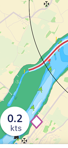
FWIW I find Google maps satellite overlay as very effective in identifying the 'gut' in a poorly charted muddy/sandy channel.

It's not foolproof for all the obvious reasons but it's something.

Not really an answer to your question but even so.
 

Marceline

Active member
Joined
12 Sep 2020
Messages
264
Visit site
thanks so much for the replies and advice everyone - really appreciated (y)

We were aiming to get to the anchorage called Foel Ferry on Menai Strait (on the Anglesey shore north of Caernarfon)

IMG_2203.PNG

We managed it last year and it was a wonderful anchorage and were keen to try and go again but ended up beached on the north shore

I think - based on the various good advice above - the biggest mistake was trying to do this on a falling tide so we'll try again when it flooding rather than ebbing

I do like idea of using the suggestion of using the depth sounder to find/'feel' way along the channel - I think we'll try that again with the north shore (as the banks are less steeper) and we'll also drive over there tonight at low tide to see where we went wrong/get photos of the channel etc

I like the suggestion also of looking at sattellite and ariel maps (we have done that somewhat - theres a beautiful 1st photo on Caernarfon Harbour Trusts website which shows the chanel we were aiming for (and the north shore beach/mud on the right hand side of the photo where we ended up on :) )

DJI_0117-1024x414.jpg


Caernarfon Harbour Trust – 53°08’N 004°16’W Caernarfon Harbour Trust is committed to providing the best service possible to its users.

but these suggestions are great thanks - really appreciated and we'll try again (on a rising tide) :)
 

Dellquay13

Well-known member
Joined
19 Feb 2021
Messages
867
Location
Boat at Milford Haven, Home in Chesterfield
Visit site
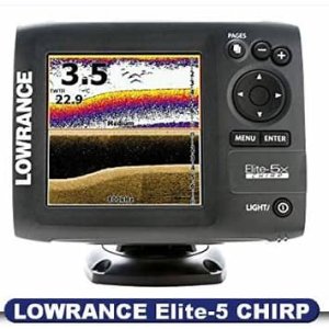
When I bought my sailboat with just a numeric depth display I really missed the detail I had on the fishfinder on my little motorboat. You could see changes in depth, seabed type, weed, all kinds of things that are handy to know. I didn’t use it for fishing, but it was invaluable when I needed interaction with or avoidance of the bottom like anchoring or feeling my way up narrow channels. The last and best I had was a Lowrance elite 5x

1717774153448.jpeg
 

RunAgroundHard

Well-known member
Joined
20 Aug 2022
Messages
1,574
Visit site
There are advanced features with modern plotter displays that process down, side and forward scanning high frequency CHIRP (Compressed High-Intensity Radiated Pulse) arrays that are far superior and would show the channel in greater detail to any traditional sonar depth detector. They are expensive but are very popular with sport fishermen. If you were updating your plotter you could consider also changing the depth sensor and integrating. Also, there are standalone fish fish finders that would be superior if they use CHIRP tech.

Sites-WestMarine-Site
 

LittleSister

Well-known member
Joined
12 Nov 2007
Messages
17,970
Location
Me Norfolk/Suffolk border - Boat Deben & Southwold
Visit site
Sonar or whatever gadgetry can be handy, but people have successfully (usually!!!) creek crawled for centuries, if not millennia, so they're a bonus, not essential. By all means buy one but also bear in mind the various techniques/wheezes that help in such a situation, especially as sometimes circumstances conspire to find us creek crawling on a falling or low tide. Use all the 'tools' available.

As suggested above, keep your speed very slow so that if you do touch bottom you can easily pull yourself off (and also in case you hit anything hard it won't cause damage. It also gives you much more time to think about the situation. (In fast running current consider going backwards, facing the current and adjusting your forward speed to give you the speed you want in the direction you want to go.

Don't overlook the lower tech options. Many habitual creek crawlers use somebody on the bow with a long bamboo (or whatever) pole to sound just ahead (and either side. Mark the depth of the bottom of the depth of the keel on the pole.

Watch the current/tide flow, if any. The fastest current side will (usually) be the steepest, and the slowest the shallowest. Watch the surface of the water for hints as to where there is negligible depth.

Watch the shore and where any streams etc. flow into the channel you're flowing.

One technique one might use is rather than keeping a fixed depth from the 'edges', try to follow the deepest part. From somewhere (usually) around the middle, weave gently side to side of wherever is deepest and see laterally where it shallows, and which side most steeply (i.e. fastest). This method not foolproof as you might find yourself following the bed of a tributary branch entering the main channel you're trying to follow.

[I have to go out now, but maybe more later.]
 

AntarcticPilot

Well-known member
Joined
4 May 2007
Messages
10,171
Location
Cambridge, UK
www.cooperandyau.co.uk
Hi - so yesterday we ended up on a sandback while heading to an anchorage down a narrow channel - thankfully was on a fairly flat bank and we had bilge keels so could float off a few hours after but the bank on the opposite side of the channel was steeper and we were very glad not to end up caught on that side

We only have a depth sounder on the boat but wondered - do those more advanced sonar 'fish finders' help when trying to see where the channel is deeper under the water ?
Fish finders only show what you've already passed over. They may indicate the trend of the bottom more clearly, but they don't look ahead.

There are forward looking echosounders, but they are fairly limited in their range, and like radar, foreground features hide background ones. They also have the potential to not see narrow channels.
 

Skysail

Well-known member
Joined
30 Sep 2004
Messages
1,164
Location
Victoria BC
Visit site
Fish finders only show what you've already passed over. They may indicate the trend of the bottom more clearly, but they don't look ahead.

There are forward looking echosounders, but they are fairly limited in their range, and like radar, foreground features hide background ones. They also have the potential to not see narrow channels.

If you have a choice use the windward side of the channel.
 

TSB240

Well-known member
Joined
17 Feb 2010
Messages
3,159
Visit site
If you are venturing any further down the Foel swatch way you need to have carefully noted the exact position of the ruined ferry jetty.

The main upright poles are mostly covered and could easily punch a big hole in your hull. I have witnessed this happening during the Strait regatta to a historic West Kirby based boat not familiar with the area.

The anchorage by the sea zoo is foul ground with discarded fishing and mooring gear. We nearly lost our main gear to a huge fisherman's anchor. It gave two very fit young men a heavy work out to lift it up enough to get a spare line on it and to free our chain and anchor.

Quite fun to explore these swatch ways all the way from Aber Menai to Plas Menai on Ynys Mon side of the Strait.
Easier on a rising tide and in a minimal draft rubber dinghy. Having a hand held gps to record a safe track that could be followed by a bigger boats is the safe established way of exploring these moving swatch ways. Don't believe anything you see on Navionics!

You can get a great view from the Royal Welsh Yacht Club or the castle if you want to make a note of the current swatch way layout.
 

johnalison

Well-known member
Joined
14 Feb 2007
Messages
39,521
Location
Essex
Visit site
Fish finders only show what you've already passed over. They may indicate the trend of the bottom more clearly, but they don't look ahead.

There are forward looking echosounders, but they are fairly limited in their range, and like radar, foreground features hide background ones. They also have the potential to not see narrow channels.
I would guess that forward-looking sounders have been around for about thirty years. I once briefly sailed on a boat with a basic version, not the Echopilot, and it didn’t seem very effective, but that was a long time ago. I would have thought that with modern electronics their performance must have improved a lot, but it may still be that conditions for their use remain limited. My Graphic Repeater will display a graphic record of depth passed over, but I only use it for entertainment value, as when passing over some of the banks in the North Sea.
 

AntarcticPilot

Well-known member
Joined
4 May 2007
Messages
10,171
Location
Cambridge, UK
www.cooperandyau.co.uk
I would guess that forward-looking sounders have been around for about thirty years. I once briefly sailed on a boat with a basic version, not the Echopilot, and it didn’t seem very effective, but that was a long time ago. I would have thought that with modern electronics their performance must have improved a lot, but it may still be that conditions for their use remain limited. My Graphic Repeater will display a graphic record of depth passed over, but I only use it for entertainment value, as when passing over some of the banks in the North Sea.
The problems are twofold. First, the power output isn't great, so the range is limited, just as it is with our depth sounders. I don't think many of us have a depth sounder that will get past 200m; mine only does 120m.Doubling the range requires 4 times the power, and you're still only at a few hundred metres range. The other point is that without using impractically large transducers, the beam width is relatively large so the resolution isn't great. These limitations result from fundamental physics, so within the constraints of the size and power supply of leisure craft you can't improve much. And if you did increase the power, you'd be in whale bothering territory!

There are also issues to do with the pulse repetition frequency - to get greater range you need a lower PRF, so the refresh rate gets slower.
 
Last edited:

johnalison

Well-known member
Joined
14 Feb 2007
Messages
39,521
Location
Essex
Visit site
The problems are twofold. First, the power output isn't great, so the range is limited, just as it is with our depth sounders. I don't think many of us have a depth sounder that will get past 200m; mine only does 120m.Doubling the range requires 4 times the power, and you're still only at a few hundred metres range. The other point is that without using impractically large transducers, the beam width is relatively large so the resolution isn't great. These limitations result from fundamental physics, so within the constraints of the size and power supply of leisure craft you can't improve much. And if you did increase the power, you'd be in whale bothering territory!

There are also issues to do with the pulse repetition frequency - to get greater range you need a lower PRF, so the refresh rate gets slower.
You’re probably right. I seem to remember recording about 200 m depth somewhere off Sweden, but even 50 m ahead, or maybe even 25 at depths of < 10 m would be useful.
We had an odd experience west of Plymouth one trip. There were navy ships around a few miles away, for what it’s worth. Although at some depth in the chart, maybe 50+, the sounder showed rapidly decreasing depth down to about 5 and suddenly back to normal, which was alarming at the time, and this happened two or three times, which made me a touch paranoid.
 

AntarcticPilot

Well-known member
Joined
4 May 2007
Messages
10,171
Location
Cambridge, UK
www.cooperandyau.co.uk
You’re probably right. I seem to remember recording about 200 m depth somewhere off Sweden, but even 50 m ahead, or maybe even 25 at depths of < 10 m would be useful.
We had an odd experience west of Plymouth one trip. There were navy ships around a few miles away, for what it’s worth. Although at some depth in the chart, maybe 50+, the sounder showed rapidly decreasing depth down to about 5 and suddenly back to normal, which was alarming at the time, and this happened two or three times, which made me a touch paranoid.
That has happened to me in the Clyde. Not sure why - perhaps a density layer? Haven't seen it on the East coast - but the depth sounder rarely goes deep enough for it to be likely!
 

LittleSister

Well-known member
Joined
12 Nov 2007
Messages
17,970
Location
Me Norfolk/Suffolk border - Boat Deben & Southwold
Visit site
. . .
We had an odd experience west of Plymouth one trip. There were navy ships around a few miles away, for what it’s worth. Although at some depth in the chart, maybe 50+, the sounder showed rapidly decreasing depth down to about 5 and suddenly back to normal, which was alarming at the time, and this happened two or three times, which made me a touch paranoid.

And without wishing to unnerve the OP too much, I was once firmly aground in soft mud while the depth sounder was insisting there was 2.5 metres under the keel, when moments before I'd been well afloat and trundling along with it reading 1m under the keel. (This in the muddy creek that leads to the back of the Havengore Bridge. Fortunately it was a rising tide, and I was soon on my way and through the bridge.)
 
Top