avoiding sandbanks with sonar

Marceline

Active member
Joined
12 Sep 2020
Messages
264
Visit site
There are advanced features with modern plotter displays that process down, side and forward scanning high frequency CHIRP (Compressed High-Intensity Radiated Pulse) arrays that are far superior and would show the channel in greater detail to any traditional sonar depth detector. They are expensive but are very popular with sport fishermen. If you were updating your plotter you could consider also changing the depth sensor and integrating. Also, there are standalone fish fish finders that would be superior if they use CHIRP tech.

Sites-WestMarine-Site
ah nice - so there a forwards and side instruments using CHIRP but are pricey
 

Marceline

Active member
Joined
12 Sep 2020
Messages
264
Visit site
Sonar or whatever gadgetry can be handy, but people have successfully (usually!!!) creek crawled for centuries, if not millennia, so they're a bonus, not essential. By all means buy one but also bear in mind the various techniques/wheezes that help in such a situation, especially as sometimes circumstances conspire to find us creek crawling on a falling or low tide. Use all the 'tools' available.

As suggested above, keep your speed very slow so that if you do touch bottom you can easily pull yourself off (and also in case you hit anything hard it won't cause damage. It also gives you much more time to think about the situation. (In fast running current consider going backwards, facing the current and adjusting your forward speed to give you the speed you want in the direction you want to go.

Don't overlook the lower tech options. Many habitual creek crawlers use somebody on the bow with a long bamboo (or whatever) pole to sound just ahead (and either side. Mark the depth of the bottom of the depth of the keel on the pole.

Watch the current/tide flow, if any. The fastest current side will (usually) be the steepest, and the slowest the shallowest. Watch the surface of the water for hints as to where there is negligible depth.

Watch the shore and where any streams etc. flow into the channel you're flowing.

One technique one might use is rather than keeping a fixed depth from the 'edges', try to follow the deepest part. From somewhere (usually) around the middle, weave gently side to side of wherever is deepest and see laterally where it shallows, and which side most steeply (i.e. fastest). This method not foolproof as you might find yourself following the bed of a tributary branch entering the main channel you're trying to follow.

[I have to go out now, but maybe more later.]
Wow -- thank you for the above and loving the various advice and suggestions

we've a nice selection of long bamboo poles in the garden so I'll take one out next time (that sounds a great idea) - and the suggestions to try and read the currents is also very helpful (hopefully we'll get better at spotting those with experience)

I liked the slow weaving suggestion as well - am sure all the above will be useful suggestions at various scenarios

many thanks for those (y)
 

Marceline

Active member
Joined
12 Sep 2020
Messages
264
Visit site
If you are venturing any further down the Foel swatch way you need to have carefully noted the exact position of the ruined ferry jetty.

The main upright poles are mostly covered and could easily punch a big hole in your hull. I have witnessed this happening during the Strait regatta to a historic West Kirby based boat not familiar with the area.

The anchorage by the sea zoo is foul ground with discarded fishing and mooring gear. We nearly lost our main gear to a huge fisherman's anchor. It gave two very fit young men a heavy work out to lift it up enough to get a spare line on it and to free our chain and anchor.

Quite fun to explore these swatch ways all the way from Aber Menai to Plas Menai on Ynys Mon side of the Strait.
Easier on a rising tide and in a minimal draft rubber dinghy. Having a hand held gps to record a safe track that could be followed by a bigger boats is the safe established way of exploring these moving swatch ways. Don't believe anything you see on Navionics!

You can get a great view from the Royal Welsh Yacht Club or the castle if you want to make a note of the current swatch way layout.

Many thanks for the advice -- especially to be wary of those poles from the ruined ferry (again sounds another very good reason to attempt this on low-rising tide. Slowy does it with someone on the bow I guess is the way to go for there (tbh that's where I'll be anyway for dropping the anchor once we've hopefully made it into that deeper pool to anchor)

and wow - I never knew people took their boats along those smaller channels in the north of the Strait to Aber Menai !!?

We have Savvy Navvy on our phones, so -- if we get more confident and practiced getting in and out of the channel to Foel Ferry from Plas Menai and anchoring at the Mermaids Inn pool west of the jetty - if we then took our dinghy (and bamboo pole from the other suggestion to make sure theres enough depth there) and found our way at lower tides to Aber Menai we could then use that saved track to take our 90cm draft boat down those ? Thats a bit mind blowing if so (never occured to us) (y)
 

Marceline

Active member
Joined
12 Sep 2020
Messages
264
Visit site
thanks also to everyone else for your suggestions and advice - really helpful as we'd rather avoid running aground again (but we're glad to have finally experienced it in a relatively safe place and then been able to get off and out) - it will at least give us some experience for if we want to take the ground somewhere in the future round here (such as Red Warf bay and heard some do this with boats that can take the ground at Abermenai) - so we'll start to learn and practice these in the months ahead
 

Roberto

Well-known member
Joined
20 Jul 2001
Messages
5,162
Location
Lorient/Paris
sybrancaleone.blogspot.com
We've sailed (actually motored) a few hundred miles in places with no nautical charts at all or where topographic charts were showing the boat on top of sand dunes (mostly West african or South american rivers/waters), mainly using traditional methods and some satellite pictures; a lot of precautions to be taken, a few minor incidents and the depth sounder alarm sometimes still haunts my nights. People get their adrenaline by racing, heavy winds etc, I can't resist a blank chart :)
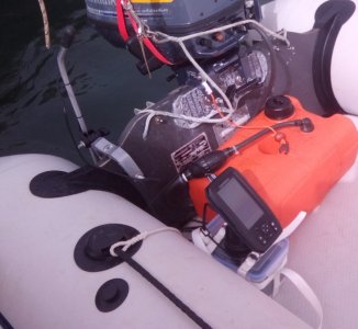
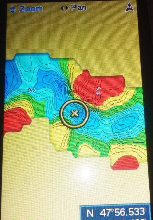
Trying to embrace modernity, I made this portable sounder (Garmin striker 4, IIRC) with a motorcycle battery in a watertight box; on the dinghy transom there is a clamp with a grey pole holding the transducer. Anchor somewhere safe, then cross several times over waters ahead with the dinghy. This sounder has the option of drawing depth contours while one is running over the area. Once done, one can reduce soundings against height of tide and draw differently coloured contours more or less against LAT (red area dries, but I went over it at the time of measurement). It's nice, in particular if you plan to go several times in the same place.
Sounds very appealing, but I strongly suggest to make several tries by yourself and check the results: it can be very useful if you made it personnally and know the limits and drawbacks of the "survey", otherwise the amount of discrepancies with reality make it totally unsafe. I would never, ever sail into a blank chart area trusting such data coming from someone else (pretty much like Navionics Sonar charts, where this kind of "wrong" input could be/are easily integrated; there are people very happy with them, so much the better, I won't elaborate once again).
Very nice way of spending one hour and seeing the "chart" build under your eyes.
strikergommone_copy_731x673.jpg


IMG_20231012_145032_3CS_copy_481x691.jpg
 

LittleSister

Well-known member
Joined
12 Nov 2007
Messages
17,970
Location
Me Norfolk/Suffolk border - Boat Deben & Southwold
Visit site
There's a little paperback called 'Running Aground and Getting Afloat' I used to have. (Where did that disappear to?) It is not about creek crawling per se, but various things to keep in mind - e.g. stay towards the upwind side of a narrow channel to reduce chances of being blown onto the shore/shallows, and if you do go aground you'll tend to be blown off, rather than harder and harder aground - and how to get yourself off if you do go aground. Reduces the chances you will aground and takes some of the fear out of it.

Seems to be out of print but there are second hand copies available various places e.g.
https://www.amazon.co.uk/Running-Aground-Getting-Afloat-Sailmate/dp/0713638966

My advice having been aground several times - only on muddy bottoms, mind - is once you've decided you are definitely stuck on a falling tide (assuming not in danger), accept your fate and, er, lean into it - get the kettle on before you heel over too far for that (may not apply to a bilge keeler), then settle down for a snooze or read, finding somewhere you can lie leaning against e.g. a cockpit coming or hull as the heeling gets steeper. Very restful.

On a rising tide I've sometimes deliberately turned out of the channel of muddy river and gone aground for 15-20 minutes to have a breather, brew and sandwich for 20 minutes without having to faff around with the anchor!

Definitely carefully avoid going aground on rocks, though, or anywhere where you might be exposed to surf or other serious waves. Sandbanks and beaches, too, are much harder than you might think - damaging and very unnerving/uncomfortable in waves - keep well clear and/or stay on the downwind side if possible.
 
Last edited:

cpedw

Well-known member
Joined
1 Jun 2001
Messages
1,260
Location
Oban
Visit site
If you're prepared to go slowly, a forward-looking leadline can help. Get a decent weight, some string and about 3 small coloured floats. Tie a float at your draft, another at draft + say 0.5m and a third at draft + 1m. Make sure the piece of string is very long. Throw the weight out ahead, holding the other end of the line, If all the floats are on the surface, go another way! Otherwise, proceed cautiously, pull in the line before it gets near the prop and repeat.
 

Juan Twothree

Well-known member
Joined
24 Aug 2010
Messages
766
Visit site
FWIW I find Google maps satellite overlay as very effective in identifying the 'gut' in a poorly charted muddy/sandy channel.

It's not foolproof for all the obvious reasons but it's something.

Not really an answer to your question but even so.

As long as the photo was taken at LW.

Google update them from time to time, so it's worth taking a screenshot of the LW image just in case it disappears.

(I'm too mean to pay for the full version of Google Earth)
 

Sandy

Well-known member
Joined
31 Aug 2011
Messages
21,064
Location
On the Celtic Fringe
duckduckgo.com
Hi - so yesterday we ended up on a sandback while heading to an anchorage down a narrow channel - thankfully was on a fairly flat bank and we had bilge keels so could float off a few hours after but the bank on the opposite side of the channel was steeper and we were very glad not to end up caught on that side

We only have a depth sounder on the boat but wondered - do those more advanced sonar 'fish finders' help when trying to see where the channel is deeper under the water ?
Did you not read the chart and tide tables?
 

OCuea

New member
Joined
8 Jun 2024
Messages
25
Visit site
Hi - so yesterday we ended up on a sandback while heading to an anchorage down a narrow channel - thankfully was on a fairly flat bank and we had bilge keels so could float off a few hours after but the bank on the opposite side of the channel was steeper and we were very glad not to end up caught on that side

We only have a depth sounder on the boat but wondered - do those more advanced sonar 'fish finders' help when trying to see where the channel is deeper under the water ?
I don’t think a fishfinder would make much difference. An expensive forward looking echo sounder would. I once stuck an echo sounder on a long bowsprit but if sailing fast it won’t help a lot but if creeping along it did help.
 
Top