Anchoring Restricted Confusion on Navionics

DanAB

New member
Joined
18 Apr 2024
Messages
3
Visit site
Hi all,

Looking for some clarification on some Navionics charts please, specifically in the Balearics, Spain. I’m new to chart reading.

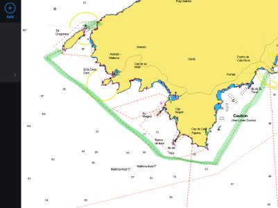
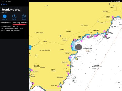
- Firstly, what is meant by “Anchoring Restricted” within the restricted area highlighted in green ? (See in attached photos) I assume I am able to anchor in these areas as all other boaters do, however I’m just wonder what is actually meant by “Anchoring Restricted”. Is it to avoid sea grass within the area? I have see anchoring prohibited areas which is quite obvious as to what this means.

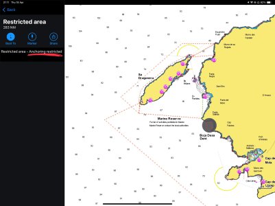
- Secondly, I have a doubt about anchoring in nature reserves. If it doesn’t state on the charts that anchoring is prohibited however I am inside a nature reserve, does this mean I am able to anchor anywhere in the area without issue? (Photo attached). Again people do seem to anchor within these areas but looking for clarification.

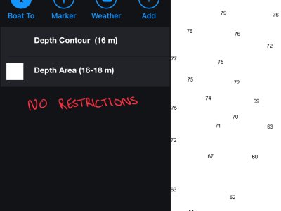
- Thirdly, If the area I am looking to anchor in isn’t protected by anything on the charts (outside of a restricted area, nature reserve, anywhere along the coast), can I anchor where I please? (Photo attached).

Thanks for the Help!

Dan
 

Attachments

  • IMG_1467.jpeg
    IMG_1467.jpeg
    1,008.6 KB · Views: 15
  • IMG_1465.jpeg
    IMG_1465.jpeg
    139.7 KB · Views: 16
  • IMG_1463.jpeg
    IMG_1463.jpeg
    471.5 KB · Views: 15
  • IMG_1462.jpeg
    IMG_1462.jpeg
    540.1 KB · Views: 17

KompetentKrew

Well-known member
Joined
27 May 2018
Messages
2,248
Visit site
For anyone else looking this up, this is the western end of Mallorca (Majorca), west of Palma. Last pic is just north of Magaluf.

This area is covered by Imray Explore, the 2023 edition of the Balearic Islands book and also the Mediterranean Almanac.

Pic 1: this is about 12 or 18 miles of coast, Explore lists several anchorages. At Playa de San Telmo (Sant Telm or San Elm), to pick one spot at random, there are mooring buoys which are managed by the Ports IB (whatever an IB is) and which require booking in peak season. There's a marina or two at Puerto de Andraitx and some sandy beaches along this coast where you can anchor. Moving south along this coast there's at least one other marina - it has an entry in both books. In all there are over 20 entries for this section of coast, although some of them very short.

The tiny little island in pic 3 has 7 entries in Explore, one for the passage, the others seem to be all very brief entries for tiny little single-boat anchorages.

The spot in pic 3, "Boja Desa Dent" is not mentioned in Imray - looks like there's an anchorage there.

elekfCV.png

I can find "passage" entries for some of the points along this coast, but I can't find anything for the whole island, anything that talks about the larger area as a whole or mentioning the nature reserve or any wider anchoring restrictions in the green area.

The spot in the 4th pic is the anchorage off Playa de Palma Nova - again, no restrictions given by the book. There's a small marina in the north of the bay, but described as silted up and only suitable for small shallow-draft mobos.

4tqGypb.png

Explore has Imray raster charts for some areas, but not this one yet.

Sorry I can't be more help, but my recommendation is take the free trial of Explore and/or buy the pilot book. I have a Navonics chip for Atlantic France to Portugal on my chartplotter and I'm sure I found at least one area in Brittany which was incorrectly marked as "no anchoring" so I wouldn't be surprised if this was a mistake.
 

john_morris_uk

Well-known member
Joined
3 Jul 2002
Messages
27,307
Location
At sea somewhere.
yachtserendipity.wordpress.com
Not sure about some of the particular questions but I sail/examine/motor regularly around that bit of coast. I’m aware that you have to be very careful about where you anchor as the Spanish authorities are clamping down severely on people anchoring in areas they’ve put as off limits. Big fines handed out. They’re allegedly trying to protect the sea grass.

The usual rule of thumb is that you can normally anchor anywhere you like unless there’s a local byelaw saying you can’t. I’m not sure it applies in the area under question. Sorry if that’s not a lot of help.
 
Last edited:

DanAB

New member
Joined
18 Apr 2024
Messages
3
Visit site
For anyone else looking this up, this is the western end of Mallorca (Majorca), west of Palma. Last pic is just north of Magaluf.

This area is covered by Imray Explore, the 2023 edition of the Balearic Islands book and also the Mediterranean Almanac.

Pic 1: this is about 12 or 18 miles of coast, Explore lists several anchorages. At Playa de San Telmo (Sant Telm or San Elm), to pick one spot at random, there are mooring buoys which are managed by the Ports IB (whatever an IB is) and which require booking in peak season. There's a marina or two at Puerto de Andraitx and some sandy beaches along this coast where you can anchor. Moving south along this coast there's at least one other marina - it has an entry in both books. In all there are over 20 entries for this section of coast, although some of them very short.

The tiny little island in pic 3 has 7 entries in Explore, one for the passage, the others seem to be all very brief entries for tiny little single-boat anchorages.

The spot in pic 3, "Boja Desa Dent" is not mentioned in Imray - looks like there's an anchorage there.

elekfCV.png

I can find "passage" entries for some of the points along this coast, but I can't find anything for the whole island, anything that talks about the larger area as a whole or mentioning the nature reserve or any wider anchoring restrictions in the green area.

The spot in the 4th pic is the anchorage off Playa de Palma Nova - again, no restrictions given by the book. There's a small marina in the north of the bay, but described as silted up and only suitable for small shallow-draft mobos.

4tqGypb.png

Explore has Imray raster charts for some areas, but not this one yet.

Sorry I can't be more help, but my recommendation is take the free trial of Explore and/or buy the pilot book. I have a Navonics chip for Atlantic France to Portugal on my chartplotter and I'm sure I found at least one area in Brittany which was incorrectly marked as "no anchoring" so I wouldn't be surprised if this was a mistake.
Hi there, thank you for the help and information, it's all very useful for me. I think my best option is to buy the "Balearic Island" book you mentioned and use this alongside my charts to really get a good idea of what the deal is in each anchorage. Again, thank you!
 

DanAB

New member
Joined
18 Apr 2024
Messages
3
Visit site
Not sure about some of the particular questions but I sail/examine/motor regularly around that bit of coast. I’m aware that you have to be very careful about where you anchor as the Spanish authorities are clamping down severely on people anchoring in areas they’ve put as off limits. Big fines handed out. They’re allegedly trying to protect the sea grass.

The usual rule of thumb is that you can normally anchor anywhere you like unless there’s a local byelaw saying you can’t. I’m not sure it applies in the area under question. Sorry if that’s not a lot of help.
Hi John,
Thanks for the information. I have seen boats anchored all over the areas I provided in the attached photos so like you have said, I think you can usually anchor anywhere, but stay of the seagrass / posidonia.
It just slightly confuses me as the whole southern section of the island (Green highlighted restricted zone) is marked as "anchoring restricted" so I just wanted to know what is actually meant by this phrase as everyone seems to anchor everywhere within this zone.
Thanks for the reply.
Dan
 

andyc352

Member
Joined
10 Apr 2018
Messages
90
Location
Portugal
Visit site
For anyone else looking this up, this is the western end of Mallorca (Majorca), west of Palma. Last pic is just north of Magaluf.

This area is covered by Imray Explore, the 2023 edition of the Balearic Islands book and also the Mediterranean Almanac.

Pic 1: this is about 12 or 18 miles of coast, Explore lists several anchorages. At Playa de San Telmo (Sant Telm or San Elm), to pick one spot at random, there are mooring buoys which are managed by the Ports IB (whatever an IB is) and which require booking in peak season. There's a marina or two at Puerto de Andraitx and some sandy beaches along this coast where you can anchor. Moving south along this coast there's at least one other marina - it has an entry in both books. In all there are over 20 entries for this section of coast, although some of them very short.

The tiny little island in pic 3 has 7 entries in Explore, one for the passage, the others seem to be all very brief entries for tiny little single-boat anchorages.

The spot in pic 3, "Boja Desa Dent" is not mentioned in Imray - looks like there's an anchorage there.

elekfCV.png

I can find "passage" entries for some of the points along this coast, but I can't find anything for the whole island, anything that talks about the larger area as a whole or mentioning the nature reserve or any wider anchoring restrictions in the green area.

The spot in the 4th pic is the anchorage off Playa de Palma Nova - again, no restrictions given by the book. There's a small marina in the north of the bay, but described as silted up and only suitable for small shallow-draft mobos.

4tqGypb.png

Explore has Imray raster charts for some areas, but not this one yet.

Sorry I can't be more help, but my recommendation is take the free trial of Explore and/or buy the pilot book. I have a Navonics chip for Atlantic France to Portugal on my chartplotter and I'm sure I found at least one area in Brittany which was incorrectly marked as "no anchoring" so I wouldn't be surprised if this was a mistake.


IB = IBÉRIA. PortsIB is the public body responsible for, among other things, certain moorings and public pontoons in the Balearics. They have local offices in the main ports.
 
Top