Which Chart Plotter?

geem

Well-known member
Joined
27 Apr 2006
Messages
8,043
Location
Caribbean
Visit site
For many ?
If your boat is mainly going to be in KAVOK and local waters a chart that is a few years out to date is not that critical .
If you are venturing into unknown foreign parts a different story ?
Must confess that not that long ago an RL80 with a chart last up dated in 2007 :eek: was used as main navigation help around south east coast, backed up with Navionics on a Ipad.
However a close eye was always kept on this website. Book Updates | ECP

Helping to install a used Garmin 4010 on a boat at the mo , it certainly appears to be superior piece of kit to my much later all singing all dancing touch screen Raymarine .
Got the hang of using the Garmin within a few moments of firing up, the less said about my attempts to master the Raymarine the better.
The only downside, older kit is nearly always a pretty substantial lump of metal to hang on any handy fibreglass.
I just ordered a new Raymarine Axion+12 RV". My old Raymarine E140W and E120W MFDs are both obsolete. I installed a new Raymarine ACU400 autopilot and lost some functionality on the existing plotters. No steering to a way point. It's been a plan to replace the aged Eseries kit for some time. That decided it for me. I purchased the Axiom in the USA. £700 cheaper than UK. Raymarine tech guys were very helpful in working out which digital radar I have. It's dates from 2010 and was on the boat when I got it. I'm didnt know the model number. They helped identify it and confirmed it is compatible with the new Axiom.
 

Refueler

Well-known member
Joined
13 Sep 2008
Messages
20,441
Location
Far away from hooray henrys
Visit site
As we all realise ... its not just money - its also what suits each person.

Still working :>
I have an old Magellan HH GPS - crap compared to old Garmin I let go with a previous boat ... Garmin 50 ? Had the folding side antena same as this Magellan.
I have a garmin Etrex - the base model ... I really like it .. batterys last well .. basic but useful. I always carry it just in case.
I have Lowrance Globalmap 3500 ... with Lowrance Charts and my own I created ... bulky for its size .. can have depth / wind etc. display on it - but not AIS. Yonks old - but still works a treat.
I have Onwa KP39A - does all I want and with free charts ... built in AIS B+
Tablet and Phone - both running Navionics App with full Baltics charting - subscription valid
Garmin Echomap 95sv UHD with Swedish Chart and updates ... plus general Baltic 2023 expired Navionics SD card

The Onwa supplies all data / AIS via NMEA2WiFi unit to all phones / tablets and the Echomap .. giving me a setup that whether at nav table .. in forecabin .. in cockpit or wherever - full data displayed.

Anyone who sails can link their phone / tablet as well and have the full data set via WiFi ...

If any one part fails - the remaining are all capable of working independently.
 

Alicatt

Well-known member
Joined
6 Nov 2017
Messages
4,891
Location
Eating in Eksel or Ice Cold in Alex
Visit site
As we all realise ... its not just money - its also what suits each person.

Still working :>
I have an old Magellan HH GPS - crap compared to old Garmin I let go with a previous boat ... Garmin 50 ? Had the folding side antena same as this Magellan.
I have a garmin Etrex - the base model ... I really like it .. batterys last well .. basic but useful. I always carry it just in case.
I have Lowrance Globalmap 3500 ... with Lowrance Charts and my own I created ... bulky for its size .. can have depth / wind etc. display on it - but not AIS. Yonks old - but still works a treat.
I have Onwa KP39A - does all I want and with free charts ... built in AIS B+
Tablet and Phone - both running Navionics App with full Baltics charting - subscription valid
Garmin Echomap 95sv UHD with Swedish Chart and updates ... plus general Baltic 2023 expired Navionics SD card

The Onwa supplies all data / AIS via NMEA2WiFi unit to all phones / tablets and the Echomap .. giving me a setup that whether at nav table .. in forecabin .. in cockpit or wherever - full data displayed.

Anyone who sails can link their phone / tablet as well and have the full data set via WiFi ...

If any one part fails - the remaining are all capable of working independently.
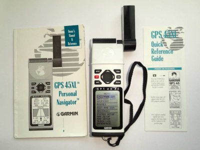
I have used a Garmin 45XL since about 1998, both for the boat and connected to my Psion 3C through a "interface" and a bit of software that allowed the Psion 3c running Autoroute to pick up the location data from the 45XL, that was my first car sat nav.
I had the 45XL's detachable antenna mounted on a window mount on the back of my Landcruiser but some person liked it better than me and it disappeared while nipping into a shop for a minute. After that I went TomTom for vehicle navigation.
The one downside of the 45XL was that it stopped/switched off the display when you reached 90knts, but it still outputted the data via the NMEA0183 and kept updating it's internal log too.
 

Refueler

Well-known member
Joined
13 Sep 2008
Messages
20,441
Location
Far away from hooray henrys
Visit site
This is the Garmin I had ..

stacks-image-2792955-530x800.jpg


Let it go with my Snapdragon 23 ....

Next boat SR25 had the Magellan Meridien XL - similar design ...

s-l500.jpg


This is the 2nd upgraded unit I used many moons ago (I know it says combined Transit Sat and Omega .. its the only picture I could find .. the one before that was a large box unit and then a dot matrix printer !! Transit !!

uxXGXUwl.jpg
 

Alicatt

Well-known member
Joined
6 Nov 2017
Messages
4,891
Location
Eating in Eksel or Ice Cold in Alex
Visit site
This is the one I have, it is still missing it's antenna but I use a mag mount one with it when I'm using it.
Garmin45XLsm.jpg

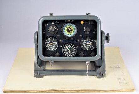
This is what I used to install on the fishing boats:
DNMk121.jpg
That's just the display head, the rest of the navigator was in a big box elsewhere connected to it by a 36 way Amphenol plug,
The rest of the equipment with the Mk12 can be seen about 1/3rd of the way down here Decca Navigator - Receivers and Indicators
I did work with the Mk5 but it was mainly removing them to replace them with the Mk12 units. The Mk12 was my introduction to working in electronics ... cleaning the relays in them, and then learning how they worked and which valves needed replacing :)
 

Refueler

Well-known member
Joined
13 Sep 2008
Messages
20,441
Location
Far away from hooray henrys
Visit site
I grew up with Mk 10 .. Mk 12 and Mk 21 Decca Navigators ... what amazed me was NASA created the little Decca Navigator for boats that actually displayed Lat and Long !! And I was still using a Mk 21 on ships .....

My Seagoing was 1973 to 1989 ... which time frame covered the sextant ... RDF ... Loran A and C (hated Loran) ... Decca .... Omega .... Transit and then GPS. As well as early days of electronic charting ...

I always was saddened by the loss of Decca .... I still have a Decca Ruler somewhere ..
 

afterpegassus

Active member
Joined
12 Mar 2009
Messages
463
Location
NW scotland
Visit site
This is the one I have, it is still missing it's antenna but I use a mag mount one with it when I'm using it.
View attachment 170409

This is what I used to install on the fishing boats:
View attachment 170410
That's just the display head, the rest of the navigator was in a big box elsewhere connected to it by a 36 way Amphenol plug,
The rest of the equipment with the Mk12 can be seen about 1/3rd of the way down here Decca Navigator - Receivers and Indicators
I did work with the Mk5 but it was mainly removing them to replace them with the Mk12 units. The Mk12 was my introduction to working in electronics ... cleaning the relays in them, and then learning how they worked and which valves needed replacing :)
I remember the mk21, only available to hire at around £1500 a year and ,of course you needed the charts with the Decca overlay to make sense of the dial readings.
I still have about a dozen rolls of the plotter paper with my favourite marks on.
 

Refueler

Well-known member
Joined
13 Sep 2008
Messages
20,441
Location
Far away from hooray henrys
Visit site
I remember the mk21, only available to hire at around £1500 a year and ,of course you needed the charts with the Decca overlay to make sense of the dial readings.
I still have about a dozen rolls of the plotter paper with my favourite marks on.

I thought I had used most of the Decca machines ... ever saw one with paper rolls ??

Used many Sounders with paper rolls ... that was required by MN guidelines so a record could be saved .... we used it to good effect in Palawan Passage on the Gas ships ..
 

Alicatt

Well-known member
Joined
6 Nov 2017
Messages
4,891
Location
Eating in Eksel or Ice Cold in Alex
Visit site
I thought I had used most of the Decca machines ... ever saw one with paper rolls ??

Used many Sounders with paper rolls ... that was required by MN guidelines so a record could be saved .... we used it to good effect in Palawan Passage on the Gas ships ..
The Mk10 was for an aircraft if I remember rightly
They also did aeronautical charts for the moving map on aircraft, I was in a twin turboprop belonging to Tennent's Caledonian in 1973 that had a Decca moving map.

A lot of the fishing boats had the plotter and used it to keep a steady track round their "secret" fishing spots, we did sell a lot of chart plotter paper as well as the Decca charts with the lanes over printed.

I started working for Decca in 1972 at Scrabster, in the old post office opposite the oil terminal at the entrance to the harbour, there were 2 engineers, a storeman and myself the apprentice/trainee, when I left Decca it was down to one guy working from home, the other engineer ended up as the janitor at Thurso Tech College, the storeman moved away and I went to work for a recording studio as their engineer.
 

justanothersailboat

Well-known member
Joined
2 Aug 2021
Messages
502
Visit site
Perhaps this is silly of me, but as a child of Generation GPS I'm sad I missed these earlier navigation technologies. They sound like the fun kind of headache.
 

Alicatt

Well-known member
Joined
6 Nov 2017
Messages
4,891
Location
Eating in Eksel or Ice Cold in Alex
Visit site
Perhaps this is silly of me, but as a child of Generation GPS I'm sad I missed these earlier navigation technologies. They sound like the fun kind of headache.
The Decca Navigation system was originally made for the D-Day landings so they could co-ordinate all the ships crossing to the landing beaches, so there was a bit of history to the system, it was used in various places all over the world, I used to have a world map that showed all the stations on it but it has gone now.
In addition to the normal Decca there was also the Decca HyperFix (we knew it as HyFix in the office) which was a translocatable system for locations than needed high precision, they set up one in the Moray Firth to position the oil rig that was off the coast at Latheron.
It was indeed fun times back then. :)
 

johnalison

Well-known member
Joined
14 Feb 2007
Messages
40,844
Location
Essex
Visit site
The Decca Navigation system was originally made for the D-Day landings so they could co-ordinate all the ships crossing to the landing beaches, so there was a bit of history to the system, it was used in various places all over the world, I used to have a world map that showed all the stations on it but it has gone now.
In addition to the normal Decca there was also the Decca HyperFix (we knew it as HyFix in the office) which was a translocatable system for locations than needed high precision, they set up one in the Moray Firth to position the oil rig that was off the coast at Latheron.
It was indeed fun times back then. :)
I thought that Decca was derived from the hyperbolic systems used in bombing but admit that I don't know the details. I first encountered Decca in the mid '80s when an English sailor showed me his Philips set in the Sixhaven, which seemed fairly miraculous at the time. This was about the first time that the system had been put into one box suitable for small boats. A friend shortly after got the Navstar Decca but I didn't get mine until my next boat in 1987.

The Navstar worked well and was instinctive to use. Station selection was automatic, though you could override this. It could take up to 20 minutes to find itself and there was several minutes or more lag in the current display. You could use this by looking for the minimum SOG when tacking, which would give a fair indication of your VMG. Putting in waypoints was a bit tedious, like on early GPSs but the alphanumeric entry was clear.
 

michael_w

Well-known member
Joined
8 Oct 2005
Messages
5,786
Visit site
My first experience with Decca aka 'Desmond' was in a very foggy Channel Race when CH1 off Cherbourg came out of the gloom like magic! What a weapon!
 

Refueler

Well-known member
Joined
13 Sep 2008
Messages
20,441
Location
Far away from hooray henrys
Visit site
The Decca Navigation system was originally made for the D-Day landings so they could co-ordinate all the ships crossing to the landing beaches, so there was a bit of history to the system, it was used in various places all over the world, I used to have a world map that showed all the stations on it but it has gone now.
In addition to the normal Decca there was also the Decca HyperFix (we knew it as HyFix in the office) which was a translocatable system for locations than needed high precision, they set up one in the Moray Firth to position the oil rig that was off the coast at Latheron.
It was indeed fun times back then. :)

You must know more than I ... being part of the Decca lot ...

I was always told as a Navigation / Deck Cadet - that Decca was a development on from the systems created for Bomber Command ... that instead of having the Dots / Dashes crossed lines - they developed the lanes to create a grid.

Its funny because my Father who was RAF Bomb Aimer Navigator on Wellingtons during the war .. then became Senior Ops in CAA .... overseeing many aspects of Commercial UK Airline Nav and operations ... whenever Decca was mentioned by me - smiled and just said - Navy taught us to navigate - but now we've moved on ...

Here he is navigating one of the B17's over Atlantic that was used in the movie War Lover ....

SRhSFbq.jpg


QTKemBx.jpg


Frame is a little distorted as its a snapshot from the 8mm Cine he recorded .....

The book 'Everything but the Flak' that was written as an account of the three B17's flown to UK for the movie - my Father was absolutely disgusted by and threw his copy n the bin - saying it was total rubbish and more sensationalised fiction.

I was very young and I just have a fleeting memory of being taken onto the B17 at Gatwick Airport after it had finished its movie roles and having been a show piece around UK ... then I was taken home - My Father then navigating the aircraft back to Canada.

Interesting tale about that aircraft .... according to my Father .. subject to memory of course ...

When 'Don' a friend of my Fathers who flew Berlin Airlift with my Father - was invited to assist sourcing B17's ... my father who by then was Ministry .. was invited to resurrect his navigation skills and help fly one from Canada to UK and then possibly back again. The aircraft was found parked outside a Pilots Bar in Canada as a monument !! but in full order. It needed servicing / checking out and certificates.
The book never mentions any of this .. in fact as my Father said - the locations of the aircraft were completely different to what he saw.
The route was of course a composite because the B17 was not capable of a single transatlantic hop ... the second photo is taken at a refueling stop.

I used to have the bubble sextant he used ... but its got lost over the many moves of house etc.
 

Alicatt

Well-known member
Joined
6 Nov 2017
Messages
4,891
Location
Eating in Eksel or Ice Cold in Alex
Visit site
The hyperbolic systems for the bombers were originally the Gee the which was being developed in the late 1930s, coincidently at the same time a team of Americans were doing the same thing as a method of measuring aircraft speed.
The ships navigation system was first employed on Anglesey in 1942 where Decca demonstrated the system to the MOD and as that test was successful they did another trial on the Moray Firth, one of the transmitters was stationed at Wick Airport for the second test, that was also very successful and Decca went into production to equip the landing ships with the navigation system.
The minesweepers used it to clear 10 lanes through a minefield leading to the beaches on Northern France and the following boats with the troops and equipment were given lane assignments to follow on through the cleared paths all using the navigation system it was called Gee Outfit QH and first used in earnest on the Dieppe raid in August 1942.
 

johnalison

Well-known member
Joined
14 Feb 2007
Messages
40,844
Location
Essex
Visit site
The hyperbolic systems for the bombers were originally the Gee the which was being developed in the late 1930s, coincidently at the same time a team of Americans were doing the same thing as a method of measuring aircraft speed.
The ships navigation system was first employed on Anglesey in 1942 where Decca demonstrated the system to the MOD and as that test was successful they did another trial on the Moray Firth, one of the transmitters was stationed at Wick Airport for the second test, that was also very successful and Decca went into production to equip the landing ships with the navigation system.
The minesweepers used it to clear 10 lanes through a minefield leading to the beaches on Northern France and the following boats with the troops and equipment were given lane assignments to follow on through the cleared paths all using the navigation system it was called Gee Outfit QH and first used in earnest on the Dieppe raid in August 1942.
There was a film about the D-day navigators a few years ago, but my personal RAM has been overwritten since then and I can’t remember if it was something posted here or elsewhere. The men in small craft did a fantastic job in staying on station in such conditions.
 
Top