Unfortunate Day Sailing on Humber

Daverw

Well-known member
Joined
2 Nov 2016
Messages
2,672
Location
Humber
Visit site

Attachments

  • IMG_0006.jpeg
    IMG_0006.jpeg
    414.3 KB · Views: 234
  • IMG_0007.jpeg
    IMG_0007.jpeg
    586.4 KB · Views: 232

AntarcticPilot

Well-known member
Joined
4 May 2007
Messages
10,058
Location
Cambridge, UK
www.cooperandyau.co.uk
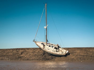
This is one of the reasons the upper Humber has to be respected and local knowledge vital, both crew taken off by Humber rescue but yacht sank on rising tide. This mud bank in middle of river about 1 m under at high water
Even commercial vessels get caught this way from time to time. The steep sides of the channels in the Humber don't take prisoners.
 

Daydream believer

Well-known member
Joined
6 Oct 2012
Messages
19,246
Location
Southminster, essex
Visit site
People say that the Thames estuary is a difficult place to navigate. I do not find it so challenging. But many years & many groundings have taught me how to handle it. - Carefully & with respect--
However, on my 2 round UK trips, I found the Humber quite difficult. It was the hardest part of the whole trips. More so, due to the high traffic volume that I encountered & the fact I arrived at night. The first time without a plotter of any sort. Even with one the second time , I still used a chart as a preference to enter the river & depart. Not the sort of place to be careless.
 

veshengro

Well-known member
Joined
23 Jan 2023
Messages
691
Visit site
" Even commercial vessels get caught this way from time to time. The steep sides of the channels in the Humber don't take prisoners."

I remember doing Pilot wheel up the Humber to Goole in one of United Baltic Company's ships in the 1960's. The Humber Pilot actually warned me, " Watch your head here she might take a sheer" and indeed that was the case. Didn't see any mud bank at that state of the tide but there was still an effect even on a fully laden Merchant Ship.
 

AntarcticPilot

Well-known member
Joined
4 May 2007
Messages
10,058
Location
Cambridge, UK
www.cooperandyau.co.uk
People say that the Thames estuary is a difficult place to navigate. I do not find it so challenging. But many years & many groundings have taught me how to handle it. - Carefully & with respect--
However, on my 2 round UK trips, I found the Humber quite difficult. It was the hardest part of the whole trips. More so, due to the high traffic volume that I encountered & the fact I arrived at night. The first time without a plotter of any sort. Even with one the second time , I still used a chart as a preference to enter the river & depart. Not the sort of place to be careless.
The Humber is a place where a plotter might lead you astray. The channels can change very quickly so your chart electronic or otherwise - might well be incorrect, even if fully corrected. Follow the buoys; they're repositioned as required, and so much more likely to keep you out of harm's way. And even then, watch out for the unexpected! I sailed there in my earliest "big boat" sailing days and wouldn't go back there from choice!
 

Pye_End

Well-known member
Joined
5 Feb 2006
Messages
5,063
Location
N Kent Coast
Visit site
Is that a Victoria 34? Any idea of the boat name? Really sad sight, especially such a nice boat. Not something you expect when going aground, but the slope makes it so dangerous.
 

Daydream believer

Well-known member
Joined
6 Oct 2012
Messages
19,246
Location
Southminster, essex
Visit site
The Humber is a place where a plotter might lead you astray. The channels can change very quickly so your chart electronic or otherwise - might well be incorrect, even if fully corrected. Follow the buoys; they're repositioned as required, and so much more likely to keep you out of harm's way. And even then, watch out for the unexpected! I sailed there in my earliest "big boat" sailing days and wouldn't go back there from choice!
That really sums up why I used the charts. I am used to echo sounder & compass. So this was much easier than staring at a screen. The plotter had already led me to hit a rock in Ardglass. :rolleyes:
 

Daverw

Well-known member
Joined
2 Nov 2016
Messages
2,672
Location
Humber
Visit site
After sailing the upper Humber for the past 9 years it can be sort of fun. The upper humber is not on electronic charts and only charted by ABP who actually map this every few weeks and do their own chart. This cliff appeared about 4 years ago from no where and unfortunately is directly in between both yacht havens. Yes you can use the marked channel but it’s quite narrow and busy with shipping so we all use a route near the north shore, unfortunately you have get round this submerged cliff to cross, The relief is when you get under the bridge onto normal charts. All this with 5-7 knots of tide.

you should see the cruisers go on this at 20knots and sit on the top for week Hoping for high springs.
 

Daverw

Well-known member
Joined
2 Nov 2016
Messages
2,672
Location
Humber
Visit site
Was soft mud but as it gets higher it has more drying time and the mud hardens, soon at neaps will be fully drying
 

AntarcticPilot

Well-known member
Joined
4 May 2007
Messages
10,058
Location
Cambridge, UK
www.cooperandyau.co.uk
If they are mudstone they have taken more than a few years to build up and solidify.
Not stone - merely mud that has been deposited and then partly dried out between tides, and somewhat compressed by overlying sediment. You could dig it with a spade, but it's solid enough to form a steep bank. It's properties derive from the proportions of silt and clay minerals; mud varies enormously in it's composition and physical properties, from semi liquid to pretty solid. Humber mud is at the solid end of the scale.

I'm guessing a bit, but I suspect a high clay proportion, but with enough silt to allow it to drain. Also, there doesn't appear to be much biological activity - burrowing organisms would soon destroy that nice layering.

Each layer might well represent deposition during a single tidal cycle; the water in the Humber qualifies as "thin mud"!

The sediment sources are very diverse. The Trent passes mainly through Mesozoic sediments, with a lot of shales and clay; the Ouse has it's headwaters in the Carboniferous rocks of the Pennines (coal measures, limestones and coarse sandstones) before passing across Mesozoic sediments in the vale of York.
 
Last edited:

Bikerwookie

Member
Joined
3 Feb 2013
Messages
93
Visit site
Charts are available for free on Humber.com. As of last week the ukho now chart the navigational marks and ships course but it is yet to be reflected on navionics charts. Redcliffe sand has been building there for the last decade or so. Vessel is has been refloated now.
 

RivalRedwing

Well-known member
Joined
9 Nov 2004
Messages
3,482
Location
Rochester, UK, boat in SYH
Visit site
RE AP's helpful reply. Below the Hjulstrom 'curve' which, as you might expect shows that clays and silts are more readily transported than sands and require calmer water speeds to be deposited. Importantly, once deposited they typically require higher flow velocities than a sand to erode them (the blue area), with erosion of a clay requiring as much energy as a cobble.... hence a mud bank can be a more permanent feature than a sandbank...

OIP.qAPYcOOyzgaUj8D1IU6qgQHaFU
 

AntarcticPilot

Well-known member
Joined
4 May 2007
Messages
10,058
Location
Cambridge, UK
www.cooperandyau.co.uk
RE AP's helpful reply. Below the Hjulstrom 'curve' which, as you might expect shows that clays and silts are more readily transported than sands and require calmer water speeds to be deposited. Importantly, once deposited they typically require higher flow velocities than a sand to erode them (the blue area), with erosion of a clay requiring as much energy as a cobble.... hence a mud bank can be a more permanent feature than a sandbank...

OIP.qAPYcOOyzgaUj8D1IU6qgQHaFU
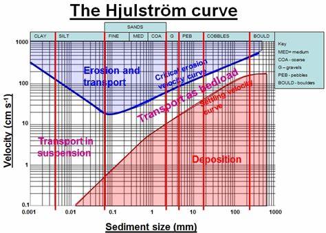
Thanks - that's a useful diagram. I note (for completeness) that the mineralogy of the sediment also has an effect; clay minerals are more likely to flocculate and cohere than quartz sand or silt, introducing some hysteresis into the erosion/deposition regime - once deposited, it will take a higher current to erode the deposit than the current that deposited it. That's why I mentioned the geology of the source areas of the rivers entering the Humber - there will be a high proportion of clay minerals in the sediment, but still a significant proportion of quartz grains (I once spent a night on a sandbank at Trent Falls, with miles of lovely clean sand around us!)
 

ianc1200

Well-known member
Joined
6 Dec 2005
Messages
3,192
Location
Frinton on Sea
Visit site
A few years ago we took two narrowboats down the Humber from Trent Falls - fascinating navigations off the Humber - the river Hull/Driffield navigation + Beverley Brook, the Market Weighton canal (we got to the derelict "Sod House lock"), and the Ancholme, we managed to use a defunct lock to get to Bishopbridge.
 
Top