Savvy Navvy on Android: Waste of money IMHO

Sgeir

Well-known member
Joined
22 Nov 2004
Messages
14,786
Location
Stirling
s14.photobucket.com
After having read favourable reviews, I was impressed by Savvy Navvy's passage planning performance on both Windows PC and Windows laptop. On the strength of that I purchased the full Android licence. It boots up reasonably well, although slowly, on two Android phones but after that, the planning function (which is its main attraction) simply does not work, apart from one or two occasions where it took several minutes to kick in. It has consistently failed to boot up at all on an Android tablet.

Both phones and the tablet tablet have maximum processing capacity and additional generous storage SD cards. Despite several uninstall/re-installs, re-boots, and having no other apps running, I have had no luck with Savvy Navvy.

Looking at previous threads, it seems to perform satisfactorily for some users, but for me, frankly, it ranks as one of the most useless pieces of boatie accoutrements that I have ever wasted my money on. And that is saying something......
 

laika

Well-known member
Joined
6 Apr 2011
Messages
8,155
Location
London / Gosport
Visit site
I was impressed by Savvy Navvy's passage planning performance on both Windows PC and Windows laptop.

It claims to be able to calculate CTS. Is it any cop at that (compared to manual)? Obviously based on you pc experience if you can't get it working on android. Anything which automates that over a long passage with anything approaching the result I get by hand would be worth a look

I've avoided trying it out because they were so aggressive in their Facebook marketing campaign it was alway in my feed. Plus it's got a stupid name....
 

robmcg

Well-known member
Joined
17 Sep 2006
Messages
1,838
Location
In exile in Scotland
Visit site
It claims to be able to calculate CTS. Is it any cop at that (compared to manual)? Obviously based on you pc experience if you can't get it working on android. Anything which automates that over a long passage with anything approaching the result I get by hand would be worth a look
Angel nav will calculate a CTS, albeit overlayed on raster, not vector charts (if that's an issue).

AngelNav
 

Dutch01527

Well-known member
Joined
7 Jul 2016
Messages
676
Visit site
But the same question applies: doing it is not necessarily the same thing as doing it well.

Bit sneaky having a quote from Tom Cunliffe on the web site about how good it is when he’s in on the business.
The quote from Tom Cunliffe makes it clear that he was involved in the development.

That being said, I am not sure what problem Angel Nav is trying to solve. A gps position is inherently more accurate than manual bearings. The chances of GPS going down are tiny. Most of us have many different GPS sources such as chart plotter, phone, tablet, VHF etc.
 
Last edited:

robmcg

Well-known member
Joined
17 Sep 2006
Messages
1,838
Location
In exile in Scotland
Visit site
That being said, I am not sure what problem Angel Nav is trying to solve
In a crowded market, where vector charts dominate, I can see your point. I think the real area of differentiation is in how the user engages with the software. There are no other charting software apps that I am aware of that allow you to apply simple manual chart work. Now there is a strong argument that says that appeals to a very small market but, we all tend to use electronic charts, why not augment their usefulness with the ability to do some basic chart work as if we were using paper charts? With the advent of tablet navigation, it's like using your paper chart in the way you would have done, but electronically. I think this approach can happily coexist with the usual vector plotting that has become the norm. Looking at the price of paper charts, it also looks increasingly more cost effective as technically you are always carrying your paper chart backup, albeit now electronically.
I like the idea - but would have to wait for an Android version (which is the version I would have launched first, from a commercial point of view).
 
Last edited:

Dutch01527

Well-known member
Joined
7 Jul 2016
Messages
676
Visit site
I understand that some people enjoy chart work and the app might be good for them. I am ex Merchant Navy and spent years navigation on paper charts. I now carry charts but do not use them. I find electronic navigation more flexible, more accurate and quicker. Only downside/danger I have found is making sure that I zoom down to the lowest level of the chart to check a plotted course or intended route. It is easy not to do so and for hidden dangers to not be visible when zoomed out.

I use Navionics. I tried Savvy Navvy last year and discovered that the modelling of route and timings was not at all accurate in the real world. That plus the very high price meant that I chose not to renew this year.
 
Last edited:

dunedin

Well-known member
Joined
3 Feb 2004
Messages
12,641
Location
Boat (over winters in) the Clyde
Visit site
The quote from Tom Cunliffe makes it clear that he was involved in the development.

That being said, I am not sure what problem Angel Nav is trying to solve. A gps position is inherently more accurate than manual bearings. The chances of GPS going down are tiny. Most of us have many different GPS sources such as chart plotter, phone, tablet, VHF etc.
The chances of GNSS/GPS going down are not necessarily “tiny”. The radio signals they rely on are very weak, and can be blocked very easily by a number of factors - natural or human caused. (Test GNSS blocking happens in UK waters regularly as part of Naval exercises, for example.). This would impact ALL your GNSS/GPS devices.

Hence the Royal Institute of Navigation has specifically called for electronic navigation software for leisure craft to have these features to allow plotting of conventional bearings etc to cater for GNSS unavailability. AngelNav is fairly unique, as far as I know, in meeting this RIN requirement.
If you know more than the RIN on this topic please feel free to educate them. And Tom C is I believe an RIN member.

However, I fear Tom’s love of raster charts may not last long term. I understand UKHO plans to withdraw the electronic raster charts when paper charts are withdrawn, as these are in effect simply the source of the printed charts. Electronic vector charts will then be the only option.
 

laika

Well-known member
Joined
6 Apr 2011
Messages
8,155
Location
London / Gosport
Visit site
I’m still not sure that any owners of these apps have commented on how good CTS calculations made by either of these apps are. It’s one area where, if done well, an app could save a lot of manual effort when planning an extended passage across a tidal area. Do they take account of predicted wind?
 

Dutch01527

Well-known member
Joined
7 Jul 2016
Messages
676
Visit site
Quote “If you know more than the RIN on this topic please feel free to educate them..”

Unnecessarily abrasive don’t you think? This is a discussion where people share opinions.

If gps fails I would use the paper chart and take bearings or use the radar.
 

robmcg

Well-known member
Joined
17 Sep 2006
Messages
1,838
Location
In exile in Scotland
Visit site
However, I fear Tom’s love of raster charts may not last long term. I understand UKHO plans to withdraw the electronic raster charts when paper charts are withdrawn, as these are in effect simply the source of the printed charts. Electronic vector charts will then be the only option.
I think that they are switching to print on demand in the future. I cannot imagine that they will get rid of the electronic versions of their raster charts as it would be the source file for any print on demand service anyway. Imray have no plans to move out of the print or electronic raster chart sector so I suppose raster charts will continue to exist.....in some form. I do agree that overwhelmingly, vector charts are always going to remain more popular as the data interrogation by the user is vastly superior to raster charts.
 

ryanroberts

Well-known member
Joined
25 Jul 2019
Messages
894
Visit site
Having used it, the CTS is pretty advisory with any tidal as the route is static and out of date by the time you have got there. Kind of like paper
 

jlavery

Well-known member
Joined
25 Oct 2020
Messages
504
Visit site
After having read favourable reviews, I was impressed by Savvy Navvy's passage planning performance on both Windows PC and Windows laptop. On the strength of that I purchased the full Android licence. It boots up reasonably well, although slowly, on two Android phones but after that, the planning function (which is its main attraction) simply does not work, apart from one or two occasions where it took several minutes to kick in. It has consistently failed to boot up at all on an Android tablet.

Both phones and the tablet tablet have maximum processing capacity and additional generous storage SD cards. Despite several uninstall/re-installs, re-boots, and having no other apps running, I have had no luck with Savvy Navvy.

Looking at previous threads, it seems to perform satisfactorily for some users, but for me, frankly, it ranks as one of the most useless pieces of boatie accoutrements that I have ever wasted my money on. And that is saying something......
Have you contacted Savvy Navvy themselves for support? There are so many Android devices and Android versions, it's not possible to test on all of them.
 

DipperToo

Active member
Joined
7 Jan 2005
Messages
675
Location
Now a formal berth at Northney
Visit site
I have found on Android that Neptune Planner works very well and as in the title, you can set date and time to plan a passage which includes tides. It can also optimise departure times and you get cts plus a ground track showing on the chart.
No affiliation, but very happy with the product at a reasonable price. Like all products, the manual needs to be read to get the most out of the product.
For some strange reason I have never seen it reviewed which is a shame.
 

AntarcticPilot

Well-known member
Joined
4 May 2007
Messages
10,095
Location
Cambridge, UK
www.cooperandyau.co.uk
I think that they are switching to print on demand in the future. I cannot imagine that they will get rid of the electronic versions of their raster charts as it would be the source file for any print on demand service anyway. Imray have no plans to move out of the print or electronic raster chart sector so I suppose raster charts will continue to exist.....in some form. I do agree that overwhelmingly, vector charts are always going to remain more popular as the data interrogation by the user is vastly superior to raster charts.
No, both raster and POD charts are done from vector data. The analogy is PDF, not an image file. There is no real connection between raster files and printed charts - both come from vector data, but using different output devices. Think of it being like the difference between printing a Word document to a hard copy device and printing it to PDF (the analogy isn't perfect but gives the right idea). The connection is through the source (vector) data and the styling applied, not directly between printed and raster data. The raster data aren't a direct copy of the printed map; they are an output parallel to the printed map.

I would be very surprised if raster data from the UKHO survive long term. Vector data are so much more flexible, are the base data for all UKHO charts (except perhaps in a few remote non-UK areas), and are essential for the ECDIS systems of ships. If charts become POD, then I can't see a rationale for the UKHO to continue to supply raster data; it would mean maintaining most of the printing pipeline simply to produce them.
 

dunedin

Well-known member
Joined
3 Feb 2004
Messages
12,641
Location
Boat (over winters in) the Clyde
Visit site
I think that they are switching to print on demand in the future. I cannot imagine that they will get rid of the electronic versions of their raster charts as it would be the source file for any print on demand service anyway. Imray have no plans to move out of the print or electronic raster chart sector so I suppose raster charts will continue to exist.....in some form. I do agree that overwhelmingly, vector charts are always going to remain more popular as the data interrogation by the user is vastly superior to raster charts.
<To continue the side tread started on AngleNav alternatives….>
Rob, I believe the UKHO is already fully on Print of Demand (via large chart agencies) for paper charts, following the withdrawal of the Small Craft Folios a couple of years ago. The main paper charts already were PoD.
What was announced more recently was the planned unilateral withdrawal of all UKHO paper charts by 2026 - since rescinded and postponed to at least 2030 (for UK waters), due to concerns raised by the CA, RIN, RYA etc. However, at this point I believe the electronic raster charts would indeed be withdrawn - as they are the bit of paper that UKHO still does, and this is the bit that is expensive in terms of human input needed (as well as more challenging to provide timely updates). So yes I expect UKHO raster charts will die when their paper does.
 

robmcg

Well-known member
Joined
17 Sep 2006
Messages
1,838
Location
In exile in Scotland
Visit site
I would be very surprised if raster data from the UKHO survive long term. Vector data are so much more flexible, are the base data for all UKHO charts (except perhaps in a few remote non-UK areas), and are essential for the ECDIS systems of ships. If charts become POD, then I can't see a rationale for the UKHO to continue to supply raster data; it would mean maintaining most of the printing pipeline simply to produce them.
I suspect that a continuation of raster charts would be done via a licensing agreement after 2030. It would be the only option if UKHO is withdrawing from that market. The source vector data is already (I presume) licensed out to other digital chart manufacturers anyway as I am not aware of a UKHO produced digital chart plotter app/ software.
Perhaps we should all think about supporting Imray in the future 🤔.
 

AntarcticPilot

Well-known member
Joined
4 May 2007
Messages
10,095
Location
Cambridge, UK
www.cooperandyau.co.uk
I suspect that a continuation of raster charts would be done via a licensing agreement after 2030. It would be the only option if UKHO is withdrawing from that market. The source vector data is already (I presume) licensed out to other digital chart manufacturers anyway as I am not aware of a UKHO produced digital chart plotter app/ software.
Perhaps we should all think about supporting Imray in the future 🤔.
The source vector data are available for ECDIS systems in the S63 (or a descendant) format. But I can't see any point in preferring raster charts; they are clumsy, inflexible, require large storage, suffer from issues with display degradation, and do not allow linking of ancillary information. In the Geographic Information world, the battle between raster and vector data was fought in the 1990s; few people have preferred raster data since then, except for certain specialized applications. As the raster data are derived from the vector data, the argument that the raster data somehow represent the source data better is simply incorrect.
 

newtothis

Well-known member
Joined
28 May 2012
Messages
1,480
Visit site
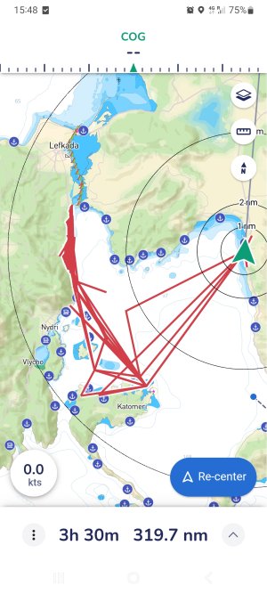
Reviving this thread only because I got a trial license of Savvy Navvy with the charter I'm on.
Not too impressed with the accuracy of its tracking function, but I'll take the 100 kts average boat speed, even if it wasn't actually where I went, or was when I took this screenshot.Screenshot_20230917_154804_savvy navvy.jpg.
 

ctva

Well-known member
Joined
8 Apr 2007
Messages
4,672
Visit site
Got a free year trial through the insurance company, downloaded it, saw that you had to pay for weather and tide info, deleted within 30mins.

Why pay for what is free in the internet?
 
Top