aidancoughlan
Member
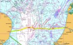
There's not many shipping lanes where we come from, and we are planning on a trip from Southwold/Lowestoft to Ijmuiden in the near future. I've been looking at charts online, and am obviously aware of the shipping lanes. The route seems fairly straightforward, but still .. there's lot's of purple lines, and I want to be sure we understand it right!.
The first "Y" shaped lane(s) ... need to cross at rightangles obviously (position (1)+(2) on the chartlet attached).
At point (3) on the chartlet, there is a defined lane north of the direct track. I've not done any tidal planning yet, but if our track takes us south of this lane - into the area circled with a Question mark... are we "officially" not in the shipping lane ? There is a large arrow going south in that circle - that's presumably indicating southbound traffic - is the size of the arrow significant (it's bigger than the two small ones coming out of the "defined" lane north of it?
Assuming we survive past those lanes, the most likely approach seems to be south of the east-west shipping lane at point (4) approaching Ijmuiden ?
There is a "defined" North-South shipping lane just south of that , at point (4A) on the chartlet (TSS Maas North I think it;s called) - we will probably pass to the north of the defined are, are we "officially" in the shipping lane at that point ?
I'm aware of the windfarm south of that lane at point (5), our plan is to head north of that, while keeping south of the big-ship channel approach Ijmuiden.
Does this all make sense, or am I missing something ? Anything else to watch out in terms of shipping traffic for that I haven't spotted ?
regards & thanks,
Aidan.
BTW, many thanks to those who chipped in on my previous thread on which Marina here http://www.ybw.com/forums/showthrea...Schichpol-airport&highlight=schipol+amsterdam. We haven't committed to a berth, but will update when we do and relate our experiences.
") Through the Gap, and then North of the Wind Farm. Usually several large ships parked here waiting,I presume, to enter the North Sea Canal. We found it on at least one occasion pretty uncomfortable and Rolly on the approach to Ijmuiden, a bit disconcerting after a 20 hour flog.
Through the Gap, and then North of the Wind Farm. Usually several large ships parked here waiting,I presume, to enter the North Sea Canal. We found it on at least one occasion pretty uncomfortable and Rolly on the approach to Ijmuiden, a bit disconcerting after a 20 hour flog.