Blue Seas
Well-Known Member
Very much appreciated folks, I'm still listening 
I think there are two issues here. First, there's the practical matter of taking sights and reducing them. That needs practice with a sextant and following a procedure using whatever method and/or tables that appeal to you. But that doesn't require my second point, which is understanding what you're doing. The books I mentioned above describe what you're doing in terms that are accessible to anyone.If you can get a copy, "Navigation with Alice" by Frank Debenham (Yes, he of Antarctic fame on Scott's expedition) is an amusing guide to the principles of celestial navigation. Also "Sextant", but I forget the author! Neither are "how to do it" but both introduce the principles in an easily digestible form.
This is "Sextant" Sextant: Book review
AI's have very much come of age now and can be very educational on their own or in conjunction with other sources, just ask like you're talking to someone. www.perplexity.ai is a good one as it collates results from various AIs & focus is one providing useful answers. Another useful tool in the learning box.Very much appreciated folks, I'm still listening
20th June 2020
Time zone 0
Mer pass
Sextant reading of LL of sun above the horizon is 67º 30.0’
Index error zero
Lower limb
Height of eye 3.0m
Slowly and step by step calculate the latitude using data from an almanac for height of eye, calculate it as if you were a sailor onboard using data from a nautical almanac
Answer
Let's calculate the latitude step-by-step using the data provided and information from a nautical almanac. We'll follow the process a sailor would use onboard.
Step 1: Correct for Index Error
Index error = 0'
Sextant altitude (Hs) = 67° 30.0'
Hs (corrected) = 67° 30.0'
Step 2: Apply Dip Correction
Height of eye = 3.0m
From the Nautical Almanac dip table:
Dip correction for 3.0m = -3.0'2
Apparent altitude (Ha) = Hs - Dip
Ha = 67° 30.0' - 3.0' = 67° 27.0'
Step 3: Apply Main Correction
From the Nautical Almanac for summer, lower limb of sun, and Ha ≈ 67°:
Main correction = +15.9'2
Observed altitude (Ho) = Ha + Main correction
Ho = 67° 27.0' + 15.9' = 67° 42.9'
Step 4: Determine Sun's Declination
Date: June 20, 2020
From the Nautical Almanac:
Sun's declination = 23° 26.1' North
Step 5: Calculate Latitude
At meridian passage (local noon), the formula for latitude is:
Latitude = (90° - Ho) + Declination (if the body and observer are on the same side of the equator)
Latitude = (90° - 67° 42.9') + 23° 26.1'
= 22° 17.1' + 23° 26.1'
= 45° 43.2' North
Therefore, the calculated latitude is approximately 45° 43.2' North.
This method demonstrates how a sailor would perform these calculations step-by-step using data from a nautical almanac while onboard a vessel.
That seems to be a subject of debate: Perplexity AI - WikipediaAI's have very much come of age ... www.perplexity.ai is a good one
I don't think so. Anything can be made difficult if you want it to be difficult.I think there are two issues here. First, there's the practical matter of taking sights and reducing them. That needs practice with a sextant and following a procedure using whatever method and/or tables that appeal to you. But that doesn't require my second point, which is understanding what you're doing. The books I mentioned above describe what you're doing in terms that are accessible to anyone.
Unfortunately, the various "quick" ways of reducing a sight actually obscure the very simple principles involved. Equally unfortunately, those simple principles can result in difficult mathematics, unless you're happy with spherical trigonometry.
I would recommend this bloke Freiberger nautical drum sextant #000086 (blue) | eBayI did my astro courses back in the 1980's (RYA/DOT at that time) but GPS was just about to come in and basically I never really used the sextant side of things after that even on ocean crossings so it never became 'natural' or routine to me. I want to take it up again for what may well be a final swansong circuit both to keep the brain cells going and as a back-up but also to get swmbo involved (she stopped at the coastal skipper stage again in the 1980's).
My question therefore is what resources (books, videos etc.) would be recommended these days? I still have my originals but the movies that were my teaching aids were the WW2 black & whites used for USAF pilots! Also, could anyone suggest a shortlist of what exercises I should be able to do to get by on rather needing to re-learn a lot of peripheral gumph that will never be used?
And yes, if anyone has a good sextant to sell......
It's a dull Sunday morning so I've blown the dust off my 1963 "New Revised Edition" of Nories.I don't think so. Anything can be made difficult if you want it to be difficult.
Spherical trig? Just accept that Napier did all the hard work some hundreds of years ago.
Also accept that while in plane trigonometry we use two parts to find a third, in spherical trig we use three parts to find a fourth.
In a simple sun sight we use sun's local hour angle, sun's declination, and our DR latitude to find the calculated zenith distance.
We also use haversines which are positive all the way from 0º to 360º which means that when combined with logarithms all our working is simple addition ( with one exception - see L~D below).
Armed with the three parts mentioned above ( and a copy of Nories tables which contains the log and nat cosines and haversines required ) it becomes -
Log Haversine Local Hour Angle (LHA)
+ Log Cosine Latitude (Lat)
+ Log Cosine Declination (DEC)
= Log Haversine 'Theta'.
Convert Log Haversine 'Theta' to Natural Haversine 'Theta'
Get the difference between the Latitude and the Declination ( L~D ) . This is sometimes additive sometimes subtractive, Simple rule 'Same Name Subtract, Opposite Name Add'
Look up Natural Haversine L~D, add to Natural Haversine 'Theta'
Nat Hav L~D + Nat Hav 'Theta' = Nat Hav Zenith Distance (ZD)
Convert Nat Hav ZD to Degrees. Job done. 9 lines of addition.
Hardly either advanced or difficult mathematics
Easier than faffing about with the air tables.
Yeah, Blewit does seem to have a fan group. But for me, along with any others, it may as well have been written in Swahili. As you say though, it doesn't matter how one learns the theory.Lots of ideas on here. But we’re all different.
I know lots of people (and several in this thread) rave about Mary Blewitt but I don’t follow her half as easily as Tom Cunliffe.
Some people find the Haversine method simple. I was brought up on AP3270 and much prefer it.
So what? My advice to the OP is to revise what her originally started with and try a few different authors/youtubers until he finds one that clicks with him. There’s no absolute best. Just ones that work for you.


Almost 2.5x as much, 1st ed. 1950Mary Blewitt. Celestial Navigation for Yachtsmen.
...
still in print after 30 years.
Even better!Almost 2.5x as much, 1st ed. 1950
I wonder if the 1st edition still used Right Ascension.Almost 2.5x as much, 1st ed. 1950
I'm actually ambidextrous. In the day job I would use Air tables for stars, Mq St Hilaire /Haversines for sun sights.It's a dull Sunday morning so I've blown the dust off my 1963 "New Revised Edition" of Nories.
Using real data I used:-
GHA 84deg 35.5min
Dec 21deg 28.7S
DR Lat 14 deg 28.5min N
One line needed to get whole angle GHA of 27deg. AP Lat 14 deg
Enter AP3270 Air Table, Lat 14, LHA 27, Dec 21, Contrary.
Adjust Hc for 28.5min Dec
Covert Z to ZD.
Seems much less of a faff, and fewer opportunities to read Tables incorrectly, than your above 9 lines of addition?
I enjoy trying new (to me) methods, but what am I missing?

this thread is a nice bit of motivation to dig out the sextant again & get some practice in
Graphing by hand is boring and reduction is just maths, once you've got the hang of 2 + 2 = 4 repeat as often as you want, ain't going to get any better..
Taking sights though is muscle memory like playing a musical instrument so seems a good idea to spend 10/20 minutes every day banging sights out like running through scales on a piano. And quicker than it took to type the 30 words asking an AI it wrote a webpage to plot sights against time.
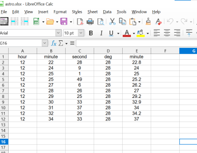
Either input one a time or save on a .xlsx spreadsheet & upload.
click here
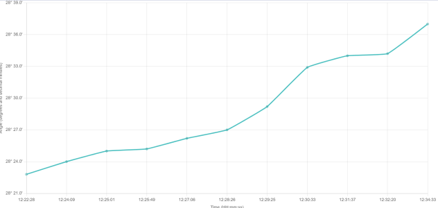
Time vs Angle Graph
There if anyone wants it, spreadsheet needs to look like >
which was a few from today.
View attachment 186728
So now it's just put the time in, trying anything which comes to mind changing halfway through & see what happens, stand different, UL or LL, bring the target up or down, try stuff with an open mind just to see what happens can be very educational & a great way to learn more imho.
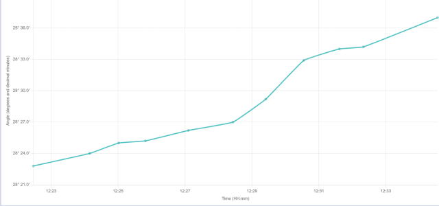
Looks like >
View attachment 186729
What's your look like?


Yeah noticed the x axis, I can't fix anything but know an AI that can...That's an interesting approach and, for you and other like-minded geeks (meant to be a compliment) combines a couple of your interests.
Re the plot: 1. can you correct X-axis scale? 2. if you show correct time/scale, can you make it draw a "best straight line fit"?

Got it to write some python as well........
The programming language was actually named after them, there's a load of little hidden references in the code.Life of Brian was their best writing, surely you can't match that