benjenbav
Well-known member
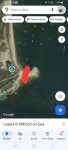
From RNLI Lymington Lifeboat:

Last edited:
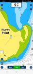
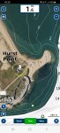
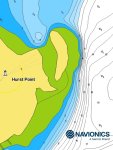
It’s not an island and is part of the spit, as stated by UKHO.
Sailing Solent? Shifting shingle sandbanks. Sudden scary surprise! Salopettes soiled.New tongue twister?
My IPAD and phone showing the updated details at hurst. Make sure the IPAD has been connected to the internet and click menu - update mapsOdd thing on (my) Navionics app: Lentune Island update is showing on the iPhone but not the iPad (which is what I use to update the plotter card). Same app subscription on phone and tablet. Both showing “charts up to date.” One to watch, if navigating by iPad….
") . Off to sync iPad to plotter…..
. Off to sync iPad to plotter…..