Decca to Lat Long conversions?

Slowboat35

Well-known member
Joined
4 Apr 2020
Messages
2,435
Visit site
AP, I think the system you were referring to was Omega, another hyperbolic system based on VLF and theoretically at least giving global coverage from only 3 or 4 base stations. It was relatively short-lived and went out with all the rest as GPS came took over in the early '90s.
Back in the '80s one of our S61s had a compact magic box that allowed you to push buttons to enter lat and longs and go from one place to another without needing beacons to follow - truly astonishing compared to the nightmare of Decca . That used a combination of Loran (accurate but local)and Omega (less accurate and near global). On the N Sea it achieved astonishing feats of accuracy, 100m or so and was alleged to never be less than 2 or 3 miles anywhere on earth which tallies with your description. Though both systems had been mentioned in basic Nav training that was the only time I ever came across either of them. You could go from one rig to another hundreds of miles apart out of range of any beacons -a nerve-wracking business otherwise using dead-reckoning and hoping your target showed up on radar, or having to identify it amongst a number of others in the vicinity.

It is worth pointing out that as well as wartime "Gee" which became Decca , Consol was a Nazi bombing system originally called Sonne (Sun). That too lasted until recent years. Intruguing that two wartime firsts continued so long. Read Dr RV Jones' magnificent book Most Secret War to get the whole story.

But back to the OP, I now recall in the mid '80s there was a widely marketed Decca set that held maybe six or eight waypoints (Wow!!) and interfaced in lat and long - it was even pretty much automatic in terms of user-intervention. They were only a few hundred pounds and were briefly popular before the first GPS saw them off forever in 1990 or so. Thus there was an affordable lat-long interface but of course it required Decca signals to make it work.

But now we understand the reason for the question the solution is as simple as I suggested. You only need the relevant Decca chart which will be readily avialable on Ebay for a modest sum and simply read off the lat and long of the Decca co-ordinates. Nothing could be easier (well, apart from plotting the Decca position!). It's well explained on t'internet, just get the relevant chart first.

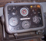
The instruments in a marine set. A cupboard full of electrickery elsewhere.
Screenshot 2021-11-25 at 17.34.51.png

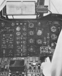
The similar kit in an S61 with a moving 'map'. To achieve a straight trackline on the yards long roller map (one roll per track) terrain was shown on a distorted hyperbolic projection(?) which made reference to terrain all but impossible.
This could be used to fly instrument approaches to 350ft! Something of a black art imho.
Screenshot 2021-11-25 at 17.42.08.png

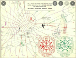
A very basic explanation using 2 channels (I've even forgotten the terminology).
Screenshot 2021-11-25 at 17.43.56.png

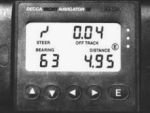
Last gasp, late 1980s. Self contained and the size of a paperback.
This one used a lat and long interface and could be comprehended and used by normal humans.
Screenshot 2021-11-25 at 17.40.17.png
 
Last edited:

AntarcticPilot

Well-known member
Joined
4 May 2007
Messages
10,070
Location
Cambridge, UK
www.cooperandyau.co.uk
OMEGA, which became operational in 1971, was the first global radio navigation system. It enabled aircraft to navigate using very low-frequency radio signals around the world. There were 8 OMEGA transmitters placed around the globe. The OMEGA system was shut down in 1997 due to the widespread use of GPS.
It was also used at sea, but it was neccessary to only all use satations and recieverthatwere in daylight or in night effect. Having some in daylight and some in night caused significant errors. It was basically an oceanic nav system of low accuracy. Because of this it was regaeded as difficult to use effectively at sea.

LORAN did not have global coverage, but did cover much of the North Atlantic and into the northern North Sea/Norwegian Sea during th cold war.
That's it! Thanks for reminding me. As I mentioned above, we found that it had pretty good precision and point-to-point accuracy, but lousy absolute accuracy; there were also occasional "jumps" in position. Its absolute accuracy was in the order of a kilometre or two, at least in Svalbard where I was attempting to use it. But it would have been fine for long distance navigation where absolute accuracy isn't vital.
 

kippers26

Member
Joined
21 Nov 2007
Messages
55
Visit site
Current Furuno GP39 navigator can be configured to show decca lanes. Some of the old Furuno GP32 models also showed Decca Lanes, cheapest solution might be to find an old Furuno GP32 or borrow one of someone.
 

fisherman

Well-known member
Joined
2 Dec 2005
Messages
19,658
Location
Far S. Cornwall
Visit site
GPS showing Decca still available when I packed up in 2018, and still are as far as I know. A Koden is easy to use in conversion, Furuno not so. Any fisherman with Maxsea or Olex can read off one to the other off the screen. There is a facility in Maxsea to adjust the LOP to account for what you expect it to show in accordance with where you understood them to be in 1996 when it was switched off.

Koden, £450! £250 when I last bought one.
Koden KGP-915 GPS

£135 here Koden GPS/DGPS Navigator KGP-913D Boxed New • £135.00
 

Slowboat35

Well-known member
Joined
4 Apr 2020
Messages
2,435
Visit site
Being able to 'show Decca lanes" is quite another thing from being able to input a Decca position and obtain a lat/long.
That doesn't say that it can convert Decca position to Lat/Long.

Once again, when the OP has finally managed to obtain the Decca reference from his informant by FAR the simplest way to find it will be to obtain the appropriate Decca-overlayed chart, plot the Decca position and read the lat/long off it - unless someone comes up with an algorithm to convert the two - which I doubt exists.

Have fun, hyperbolics is (are?) a mind-bending business!
 
Last edited:
  • Like
Reactions: srm

fisherman

Well-known member
Joined
2 Dec 2005
Messages
19,658
Location
Far S. Cornwall
Visit site
The KGP913D , which I used, takes inputs in either L/L or Decca and reads out both, so instant conversion. Using a chart for conversion won't find you a wreck, you'll be lucky to get within a half mile. Even using the Koden you will probably have to scour the area for twenty minutes, with a decent echo sounder showing bottom features.
 
Last edited:

fisherman

Well-known member
Joined
2 Dec 2005
Messages
19,658
Location
Far S. Cornwall
Visit site
The Decca Yacht navigator came out in about 1980, cost £2k. It used Decca to readout lat/long, and if you kept an error on one decca station it would show the other two all the time, otherwise it was time limited. It had a grand total of three waypoints. It was the size of a large biscuit tin. Of course you had to know your position at the start in L/L. Decca was basically a counting machine that ticked off the lanes as you crossed them.
In about 1986 I showed my neighbour a, by now small, book sized, GPS, he flew Airstreams for the Navy. They were still using old Decca machines with the three large boxes......in an aircraft where weight was critical sometimes.
 

Hoolie

Well-known member
Joined
3 Mar 2005
Messages
7,738
Location
Hants/Lozère
Visit site
They were obviously using outdated equipment.
Long before that we had a two box system using the Mk19 airborne receiver that had lane ident capabilities, coupled with the compact single unit TANS navigation computer that converted the Decca readings to lat/long and Transverse Mercator grid coordinates. It had 10 waypoints that linked as a route to drive the flight director instrument for the pilot. The Decca conversion gave a new fix and steering info approximately once a second - not bad going for a device that long predated microprocessors!

ps For many years this was the standard fit for the north sea oil rig support helicopters.

pps We had a similar system using a single box Loran C receiver that also did conversions to lat/long.
 
Last edited:

Slowboat35

Well-known member
Joined
4 Apr 2020
Messages
2,435
Visit site
I wasassuming he finds a Decca overlayed standard marine or aviation chart. Strange Decca projections won't be much help with lat and long! I f so datum will be standard WGS84 but if one of the machines mentioned above can be found in working order that may be an easier way than searching for charts.
 

AntarcticPilot

Well-known member
Joined
4 May 2007
Messages
10,070
Location
Cambridge, UK
www.cooperandyau.co.uk
I wasassuming he finds a Decca overlayed standard marine or aviation chart. Strange Decca projections won't be much help with lat and long! I f so datum will be standard WGS84 but if one of the machines mentioned above can be found in working order that may be an easier way than searching for charts.
Given that Decca transmissions in UK waters ceased in the year 2000, Decca charts are unlikely to be on WGS84. In UK waters they will be on OSGB36, which differs from WGS84 by amounts in the 100m range - about the same as the accuracy of Decca.
 

MINESAPINT2

Member
Joined
23 Nov 2007
Messages
136
Visit site
I am of the same opinion as Fisherman in post 27 above. It would be a miracle if I plotted some Decca co ordinates onto a chart and read off the Lat Long then were lucky enough to find a wreck. Considering the scale of a chart a sharp pencil line on a chart would represent several hundred metres. I do know a fisherman with Olex so I might have to persuade him to let me have a go with it. Just very awkward at the moment with Covid. I fully expected with all the effort contributed to this thread by all of you someone would have found an online conversion tool.

Thanks

Mike
 

AntarcticPilot

Well-known member
Joined
4 May 2007
Messages
10,070
Location
Cambridge, UK
www.cooperandyau.co.uk
I am of the same opinion as Fisherman in post 27 above. It would be a miracle if I plotted some Decca co ordinates onto a chart and read off the Lat Long then were lucky enough to find a wreck. Considering the scale of a chart a sharp pencil line on a chart would represent several hundred metres. I do know a fisherman with Olex so I might have to persuade him to let me have a go with it. Just very awkward at the moment with Covid. I fully expected with all the effort contributed to this thread by all of you someone would have found an online conversion tool.

Thanks

Mike
I think the problem is simply that Decca died 21 years ago, and was dying for several years before then; the powers that be wouldn't have switched it off if there was a substantial user community. Even if someone did write an online converter, the chances of it being migrated to new servers over the 21 years since then are negligible. And, while a straightforward treatment of the maths would be something I could perhaps have done (I've done worse!) the secondary problem is that refraction over coastlines and high ground means that getting accurate positions isn't straightforward. An online converter would have substantial residual errors; @fisherman and others have noted that it was good if you could use it to navigate relative to a known location at a fixed time of day. but otherwise had errors in the 200m range.

If it's an isolated pinnacle, surely a modern chart would show it? It would be obvious on swath bathymetry, and most of the North Sea has been covered by high-resolution bathymetric surveys for oil and gas and wind farm purposes.
 

srm

Well-known member
Joined
16 May 2004
Messages
2,770
Location
Azores, Terceira.
Visit site
I used to run a training exercise for a 6th year school class where they had to navigate using Decca to get over one of the large WW1 German battleship wrecks in Scapa Flow. Once at the Decca co-ordinates the echo sounder would still be showing relatively flat sea bed. They then had to run a search pattern to find the wreck by echo sounder.
Admittedly, Scapa Flow, being land locked had extreme Decca errors but it provided a good end exercise to an otherwise classroom based electronic navigation course.
Unfortunately, the college soon lost the training boat to education cuts.

Given that Decca transmissions in UK waters ceased in the year 2000, Decca charts are unlikely to be on WGS84.

As I mentioned in an early post Admiralty Hydrographic Office phased in new chart editions based on WGS84 over a number of years. I can not remember the years involved but think it started in the late 80's and am fairly certain that by the time Decca was turned off around the UK all the home waters charts would have been on WGS84 as I was not covering different chart datums in the STCW, RADAR and electronic nav simulator courses for MN candidates at that time. It is possible that a late Decca overlay chart may be on WGS84.
 
Last edited:

fisherman

Well-known member
Joined
2 Dec 2005
Messages
19,658
Location
Far S. Cornwall
Visit site
One of my colleagues had a file inches thick of wreck locations. Can't find it anywhere.
Almost any fishing boat will still have a decca capable machine. Even if you can't enter decca, and the ones I had could, you could try Lat long waypoints and convert, until you got the decca you wanted. Fairly simple to adjust a latlong entry to match a known decca adjustment. I used to know what a tenth of a lane was in deg/min/decimal as a matter of everyday work. Also a marine electronics outlet will probably have a demo maxsea, and simply hovering the cursor at a decca reading will give you lat long.

Buy the info here:
https://www.wrecksite.eu/Wrecksite.aspx
 
Last edited:

MINESAPINT2

Member
Joined
23 Nov 2007
Messages
136
Visit site
Thanks, Just to be clear, if I happen to be able to prize the Decca reading out of the hands of the fisherman who has kept it secret for so many years he has told me it is a peak (not a wreck) although I am not sure how you can be so sure unless divers have been down. Some of these Cod Bangers can be very small, I did hear of a mark where trawlers used to get some big hauls of Cod until one day a Spitfire engine came up in the nets and that was the last they saw of the Cod.

I did have a subscription to wrecksite about 10 years ago and spent a considerable period of time comparing my readings with the ones on their site. I did discover quite a number of readings on their site I was not aware of but also discovered I had 130 wrecks in the North Sea they were not aware of (at that time) although I am sure there have been quite a number of surveys since.

Mike
 

Wing Mark

Well-known member
Joined
29 Sep 2021
Messages
1,129
Visit site
It's 'easy' apparently:
http://www.pkoeze.nl/publications/ConversionCoordinates.pdf

As I understand it, a lot of the problem is that you really need to do some of the calculations to a high precision, using 1980s 16bit microprocessors was a big part of the problems.
Some of these errors could vary from one Decca receiver to another.

It's probably a waste of time anyway, quite likely whatever was of interest has been destroyed by trawlers by now, if it's not something you can find by looking at the charts.
 
Top