Deben Entrance, buoys now re-positioned for 2022.

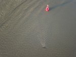
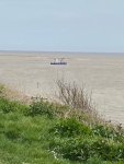
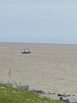
Here are the photos taken this morning 17th April at 6.30 with the Harwich Tide gauge showing 0.1m above Chart Datum, so that's about as low as it gets. The bar line shows up well.

The Knoll Spit maybe in the right place for the deepest channel, although it looks like it has been placed on top of the bar. Could it be that the buoy mooring block is just breaking water in the bottom photo?

As can be seen the navigation channel is very narrow to the East of the Knoll Spit.

I will repeat the photo when the off station West Knoll buoy is re-positioned.

DJI_0544 (1320 x 990).jpg
DJI_0546 (1320 x 990).jpg

DJI_0559 (1320 x 990).jpg
 
What an amazing resource drones are. The efforts of Those Magnificent Men (not) in Their Flying Machines are much appreciated by this ‘somewhat accident prone’ sailor.

… and obviously the same goes to Trinity House, ECP, Imray, Harbourmaster et al.
 
I’ve been into the Deben before, but as I see it now in the video, a it seems to me that it could well do with a couple of buoys more
 
Congratulations on the video Johnah, some superb footage. Makes you wonder when the north channel will become useable for leisure boats.

To be honest if you take it slow, depending on your craft and go at near to high water I think the North channel is ok now. The fishing boats certainly use it.
 
the shingle bank extending towards the south has made the entrance a bit more intimidating, but it's fine if you treat it as a half tide entrance, and there isn't an on shore gale blowing.

Potentially the north channel could become the main entrance in time, which might make things a bit simpler.
 
J
The chartlets are now available on www.eastcoastpilot.com, and are free downloads as usual. They did get done for Easter after all - phew!
I think that in view of one or two of the comments earlier in this thread, I would like to pass a few observations about how these chartlets come to be available at all as perhaps some are not aware of the detail.
- Trinity House do us all, plus local fisherman, a big favour by paying for and carrying out a survey of these entrances each year. Their normal remit involves provision of navaids only for areas carrying significant commercial traffic.
- when a previous provider of entrance charts for these rivers withdrew some years ago, the authors of East Coast Pilot suggested to their publishers, the chart agents Imrays, that they might ask Trinity House if they would be willing to give Imrays early sight of the survey data. Such survey information usually goes straight to the UKHO, nobody else. Imrays did indeed take up this suggestion, and Trinity House did agree that, as soon as they had studied the survey data each year and decided upon buoy positions, they would indeed share the data with Imrays.
- On receipt of the data, Imrays then draw the chartlets for us at East Coast Pilot to publish, solely on our website. Trinity House insists (quite rightly) on checking the chartlets before publication. Imrays get no return for this work, nor does the East Coast Pilot team, the chartlets being made available to download totally free.
So there is a fortunate chain of events each year, by quite a few people effectively going out of their way to get this all done, without which the chartlets would simply not exist. Long may the arrangements last!
Thanks, Dick both for the chartlet and for your explanation of its genesis, published in good time for our shakedown on Mayday weekend.

I'm looking forward to trying out th slightly controversial new Buoyage.

Aiming for the Tide Mill with 6 foot draft, we will necessarily be crossing well before HW.

Peter.
 
Yes John White thinks so, the sinker has been put on the bar rather than to one side of it. I hovered the drone right over it (photo below) although it couldn't focus that well.

Watch out if you are scraping over the bar! Thanks btw.
 

Attachments

  • DJI_0560 (1320 x 990).jpg
    DJI_0560 (1320 x 990).jpg
    156.6 KB · Views: 522
Yes John White thinks so, the sinker has been put on the bar rather than to one side of it. I hovered the drone right over it (photo below) although it couldn't focus that well.

Watch out if you are scraping over the bar! Thanks btw.

I think that is Johnah's wallet. Apparently he dropped it when last going over the bar. Been searching for it with his drone ever since :oops:
 
My spies (who are ranged all along the coast in the undergrowth) spotted one or more of the Deben buoys being re-positioned this morning - 19th April.

Will check them out later.

John
 

Attachments

  • !cid_2492C1F0-C329-4463-88CC-943918AB6950-L0-001.jpg
    !cid_2492C1F0-C329-4463-88CC-943918AB6950-L0-001.jpg
    61.9 KB · Views: 73
  • !cid_B7463701-D14C-4C60-8B36-33E565AEB682-L0-001.jpg
    !cid_B7463701-D14C-4C60-8B36-33E565AEB682-L0-001.jpg
    37.6 KB · Views: 69
If the entrance continues to head south is it time for a East Cardinal by the Walton Fort? I know we should be approaching from the safe water mark but us shallow craft usually cut Landguard if coming from Harwich. Almost a straight line.....
 
If the entrance continues to head south is it time for a East Cardinal by the Walton Fort? I know we should be approaching from the safe water mark but us shallow craft usually cut Landguard if coming from Harwich. Almost a straight line.....
I think, from what I know about fluvial sedimentology, that the present entrance will eventually get shallower and a new entrance will form - indeed is forming - to the north. It will be a regular progression; the entrance moves southward because of longshore drift building a spit from the northern bank of the river, which elongated southward until the river flow is too weak and the bar gets shallower, and the river then breaks through the spit at the northern end. I agree with those who suggest that in a few years, the main channel will switch to the northern position, which is already viable with local knowledge.
 
Top