Autopilot at Zero Longitude.

AntarcticPilot

Well-known member
Joined
4 May 2007
Messages
10,550
Location
Cambridge, UK
www.cooperandyau.co.uk
I can't understand a software problem at the 0⁰ longitude - everything behaves as expected there; divide by zero or NaN shouldn't arise. Problems arise at 180° where you go from +179.99999° to -179.99999°, though, and older Raymarine kit has a known problem there (it selects features for display using a box that goes all round the world, not across the 180° meridian!)
 

dunedin

Well-known member
Joined
3 Feb 2004
Messages
13,982
Location
Boat (over winters in) the Clyde
Visit site
I can't understand a software problem at the 0⁰ longitude - everything behaves as expected there; divide by zero or NaN shouldn't arise. Problems arise at 180° where you go from +179.99999° to -179.99999°, though, and older Raymarine kit has a known problem there (it selects features for display using a box that goes all round the world, not across the 180° meridian!)
Yes, and because the Greenwich Meridian is on a very busy yacht and ship route crossed very frequently, any generic software bug would have been uncovered almost immediately. Sounds like the OP had a different issue or coincidence.
 

mjcoon

Well-known member
Joined
18 Jun 2011
Messages
4,635
Location
Berkshire, UK
www.mjcoon.plus.com
I can't understand a software problem at the 0⁰ longitude - everything behaves as expected there; divide by zero or NaN shouldn't arise. Problems arise at 180° where you go from +179.99999° to -179.99999°, though, and older Raymarine kit has a known problem there (it selects features for display using a box that goes all round the world, not across the 180° meridian!)
That's a very simplistic viewpoint. We don't know what the plotter was trying to calculate, bearing to a waypoint, or whatever. Presumably these days they work solely in WGS84 so do not have to do the challenging 3D geometry calculations to get to other datums...
 

AntarcticPilot

Well-known member
Joined
4 May 2007
Messages
10,550
Location
Cambridge, UK
www.cooperandyau.co.uk
That's a very simplistic viewpoint. We don't know what the plotter was trying to calculate, bearing to a waypoint, or whatever. Presumably these days they work solely in WGS84 so do not have to do the challenging 3D geometry calculations to get to other datums...
Simplistic works in this case. I implemented this kind of software for many years, and while I encountered problems aplenty at 180°, I never had a problem at 0°. Problems at +90° and -90° latitude also happened. But at 0, all the relevant functions are continuous and well behaved.

I agree that datum shifts are unusual these days, but many GPS systems still have the ability to use datums other than WGS84; OSGB36 and ED50 come to mind. It's something I've never had to implement, but I think it's a straightforward set of equations using a set of up to 11 coefficients.
 

justanothersailboat

Well-known member
Joined
2 Aug 2021
Messages
513
Visit site
I used to implement geographical software on a much, much humbler level than AntarcticPilot (as an approximate analogy to the level of seriousness, think him:"your charts" vs me:"your school atlas" ) and honestly I'd be unsurprised, but really disappointed if commercial navigation software had any trouble with any of this. It's basic edge case handling, so what if the angle is 361, the software should take it in its stride.

(from another job in another field, I learned that "unit test" is a quite rude word in the language of a country where a lot of software is outsourced to, so who knows)
 

Frank Holden

Well-known member
Joined
23 Nov 2009
Messages
1,097
Location
Cruising in the Golfo Corcovado
Visit site
The seals may not be fat for much longer. Those waters have been overfished for decades, it will be as dead as the Atacama before too long.
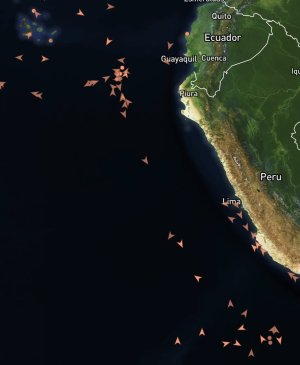
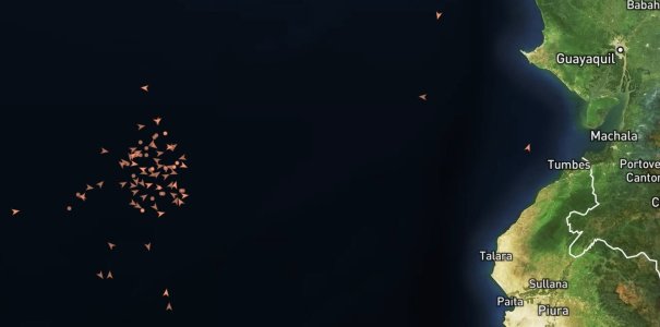
You can see the mainly chinese fishing boats in the two attached screenshots, second one is zoomed in to the waters off the Peru/Ecuador border to show the actual numbers. Fishing the living daylights out of it just outside the 200 mile limit.

And don't get me started on the rape of the South Pacific mackerel fishery. It takes 4kg of fishmeal made from mackerel to produce 1kg of farmed salmon.peru1.jpg

peru2.jpg
 
Top