tillergirl
Well-known member
New local Notice to Mariners from Harwich Haven Authority:
Channel Deepening Dredging and Beneficial Placements
Mariners are advised that work is due to start on the Harwich Haven Channel Deepening Project.
On or around the 30 September 2021 the trailer suction hopper dredger Sospan Dau (IMO number: 7711062) will start dredging the main channel, disposing of material to the beneficial disposal schemes at Horsey Island and Mersea Harbour.
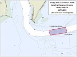
The dredging contractor is the Boskalis Westminster / Van Oord Joint Venture appointed by the Harwich Haven Authority to carry out the Harwich Haven Channel Deepening Project. The dredge area is a section of the main channel known as area C2 covering the whole width of the main channel and running from about 250m east of the Platters / Pitching Ground buoys to about 1,000m west of the same buoys. (See attached sketch HHA C2) Dredged material will be disposed of to two beneficial disposal schemes, one on the northern end of Horsey Island (Hamford Water) and to four separate sites in Mersea Harbour (at Cobmarsh Island, Old Hall Marsh, Tollesbury Wick and Packing Marsh Island).
The current programme is to commence disposal work at Horsey Island, on or about 30 September 2021. Disposal will be carried on every high water (weather permitting), day and night, either by direct pumping of material over the bow of the dredger, or via a floating pipeline. Connection of the dredger to the pipeline and positioning the placement end will be carried out by a Multicat MCS Anekke (IMO number: 9570905) and a small workboat. The floating pipeline will be held in place with anchors and marked with yellow can buoys fitted with flashing yellow lights.
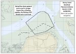
The aim of the scheme is to place sand and gravel within the area between the beach and the old lighters. The dredger will dispose only at high water and be positioned as close to the disposal area as possible (see attached sketch HI 001)
Mariners are requested to keep clear of the equipment and the site of the placement works. Work at Horsey Island is likely to take around five weeks, after which disposal operations will move to Mersea Harbour. The dredging is covered by the MMO licence held by Harwich Haven Authority: L/2020/00360/2. The disposal of material at Horsey Island is covered by MMO licence held by the RSPB: L/2020/00456/1. The disposal of material at Mersea Harbour is covered by MMO licence held by the Mersea Harbour Protection Trust: L/2018/00131/3.
Further Notice to Mariners will be issued if any of these arrangements change and before the works move to Mersea Harbour. Dredger movements will be reported to Harwich VTS on VHF 71.
(I'll add the images shortly)
Channel Deepening Dredging and Beneficial Placements
Mariners are advised that work is due to start on the Harwich Haven Channel Deepening Project.
On or around the 30 September 2021 the trailer suction hopper dredger Sospan Dau (IMO number: 7711062) will start dredging the main channel, disposing of material to the beneficial disposal schemes at Horsey Island and Mersea Harbour.
The dredging contractor is the Boskalis Westminster / Van Oord Joint Venture appointed by the Harwich Haven Authority to carry out the Harwich Haven Channel Deepening Project. The dredge area is a section of the main channel known as area C2 covering the whole width of the main channel and running from about 250m east of the Platters / Pitching Ground buoys to about 1,000m west of the same buoys. (See attached sketch HHA C2) Dredged material will be disposed of to two beneficial disposal schemes, one on the northern end of Horsey Island (Hamford Water) and to four separate sites in Mersea Harbour (at Cobmarsh Island, Old Hall Marsh, Tollesbury Wick and Packing Marsh Island).
The current programme is to commence disposal work at Horsey Island, on or about 30 September 2021. Disposal will be carried on every high water (weather permitting), day and night, either by direct pumping of material over the bow of the dredger, or via a floating pipeline. Connection of the dredger to the pipeline and positioning the placement end will be carried out by a Multicat MCS Anekke (IMO number: 9570905) and a small workboat. The floating pipeline will be held in place with anchors and marked with yellow can buoys fitted with flashing yellow lights.
The aim of the scheme is to place sand and gravel within the area between the beach and the old lighters. The dredger will dispose only at high water and be positioned as close to the disposal area as possible (see attached sketch HI 001)
Mariners are requested to keep clear of the equipment and the site of the placement works. Work at Horsey Island is likely to take around five weeks, after which disposal operations will move to Mersea Harbour. The dredging is covered by the MMO licence held by Harwich Haven Authority: L/2020/00360/2. The disposal of material at Horsey Island is covered by MMO licence held by the RSPB: L/2020/00456/1. The disposal of material at Mersea Harbour is covered by MMO licence held by the Mersea Harbour Protection Trust: L/2018/00131/3.
Further Notice to Mariners will be issued if any of these arrangements change and before the works move to Mersea Harbour. Dredger movements will be reported to Harwich VTS on VHF 71.
(I'll add the images shortly)
 Stone Creek could once again become a useful short cut for those entering the Backwaters from The Wallet and the south. No need to go all the way around to the Pye End Buoy.