Where the 112.5 degrees comes from...

AntarcticPilot

Well-known member
Joined
4 May 2007
Messages
10,092
Location
Cambridge, UK
www.cooperandyau.co.uk
Revolutionary France tried 400 gradians, or gons, in a circle. They were never much used, although my ancient TI-33 calculator (1978?) does them.
Actually, still used by French surveyors. A lot of surveying instruments have"grads" as an alternative unit of angular measure.

Entirely agree that Radians are the sensible unit for a lot of things; it removes arbitrary constants from a lot of equations. One constant bugbear for me was having to remember to implement degrees to radians and radians to degrees when I wrote libraries to handle map projections. Not many languages have them built in - the best you can hope for is a defined value of Pi with an accuracy suitable for the floating-point representation in use (I'm old enough that floating-point numbers weren't standardized when I started).

The French system did integrate various measures very neatly - the original definition of the metre was that the distance from the equator to the pole was 10,000,000 metres (10,000 km), so 1 grad = 100 km. Unfortunately, the earth isn't a sphere so you can't measure the length of an arc of latitude at any point and still get the same answer, so it was rapidly changed to being the length between two marks on a bar of precious metal. The original definition is close enough to be useful for approximations - I forget the exact accuracy, but it's good to better than 1%, I think.
 

Refueler

Well-known member
Joined
13 Sep 2008
Messages
17,778
Location
Far away from hooray henrys
Visit site
Just to comment ... the metre was originally based on a fixed metal bar at constant temp / pressure ... after the erroneous use of the Great Circle distance equator to North Pole.

Later it was revised to the distance a beam of light travels in a vacuum.
 

Refueler

Well-known member
Joined
13 Sep 2008
Messages
17,778
Location
Far away from hooray henrys
Visit site
But being french, they would only have worked 5 of them, so 10 days in a week would have been pointless,-------- because even then the wind would not still blow on the days off

Don't forget 1 day organising and 1 day after organising ... so 5 days becomes 3 ...

Now we deduct Pasti's time .... each of those 3 days become 3 hours 'work' ...
 

Spirit (of Glenans)

Well-known member
Joined
28 Mar 2017
Messages
3,347
Location
Me; Nth County Dublin, Boat;Malahide
Visit site
I'll throw Mils into the equation just to confuse everyone!

Mils

Mils are largely used by the military. The original system divides the face of the compass into 6283 divisions (Mils being short for mili-radians, derived from there being 2 Pi Radians in a circle, so 2 x 3.1416 or 6.283 mil-radians). Most Mils compasses however round this up into 6400 divisions for easier calculations. It is how bearings are described for artillery, mortar and tank fire and military handheld compasses use the same system. It can also be useful for determining range and scale – for example two objects that appear to be 100mils apart and are 1000m away from the observer are around 100m apart on the ground.
......and 6400 fits in neatly with the old 32-point compass.
 

Spirit (of Glenans)

Well-known member
Joined
28 Mar 2017
Messages
3,347
Location
Me; Nth County Dublin, Boat;Malahide
Visit site
Spin off from the jargon thread...

As we all know , sidelights are intended to be visible over an arc of 112.5 degrees or ten compass points, and there are 32 points on the old style compass card. So one point is 11.25 degrees. Why?

Well, I remember from a French sailing textbook that if you hold your arm out straight and make a fist with your hand the angle between your thumb and the other side of your hand is 11.25 degrees.

And the French for “a fist” is “un poing”.
1. Because 360 divided by 32 equals 11.25
2. The rule of thumb in the Glenans Manual is a "handy"way of judging that angle. All the rest of this discussion is just idle chat:)
 

Roberto

Well-known member
Joined
20 Jul 2001
Messages
5,091
Location
Lorient/Paris
sybrancaleone.blogspot.com

Besides measuring angles, these are useful to evaluating the distance from an object of given size/width.
If one "covers" say a 10m long boat with three fingers (5deg), the boat is approximately at 120m (12x its size), if it is covered by the two extreme fingers/15deg then it is at about 4x the distance, roughly 40m.
If there is one person on the quay and one has to evaluate the appropriate distance where to drop anchor and moor stern-to, one person height covered by one thumb (about 3deg) will locate the boat at about 20x the person height, 35-40m
 

lw395

Well-known member
Joined
16 May 2007
Messages
41,951
Visit site
Actually, still used by French surveyors. A lot of surveying instruments have"grads" as an alternative unit of angular measure.

Entirely agree that Radians are the sensible unit for a lot of things; it removes arbitrary constants from a lot of equations. One constant bugbear for me was having to remember to implement degrees to radians and radians to degrees when I wrote libraries to handle map projections. Not many languages have them built in - the best you can hope for is a defined value of Pi with an accuracy suitable for the floating-point representation in use (I'm old enough that floating-point numbers weren't standardized when I started).

The French system did integrate various measures very neatly - the original definition of the metre was that the distance from the equator to the pole was 10,000,000 metres (10,000 km), so 1 grad = 100 km. Unfortunately, the earth isn't a sphere so you can't measure the length of an arc of latitude at any point and still get the same answer, so it was rapidly changed to being the length between two marks on a bar of precious metal. The original definition is close enough to be useful for approximations - I forget the exact accuracy, but it's good to better than 1%, I think.
Don't some artillery pieces use Grad for azimuth and Mil for elevation?
 

lw395

Well-known member
Joined
16 May 2007
Messages
41,951
Visit site
Besides measuring angles, these are useful to evaluating the distance from an object of given size/width.
If one "covers" say a 10m long boat with three fingers (5deg), the boat is approximately at 120m (12x its size), if it is covered by the two extreme fingers/15deg then it is at about 4x the distance, roughly 40m.
If there is one person on the quay and one has to evaluate the appropriate distance where to drop anchor and moor stern-to, one person height covered by one thumb (about 3deg) will locate the boat at about 20x the person height, 35-40m
A fingerwidth is about 2% of an arm's length.
So a 10m boat being 3 fingers, 10m is 6% of the range so it's about 160m away.
I don't think degrees bring much to this particular party.

It's funny, we all use 1 in 4 or 25% for a steep hill, few people will talk about a 10degree hill (unless they mean a cold one...).
 

Roberto

Well-known member
Joined
20 Jul 2001
Messages
5,091
Location
Lorient/Paris
sybrancaleone.blogspot.com
A fingerwidth is about 2% of an arm's length.
So a 10m boat being 3 fingers, 10m is 6% of the range so it's about 160m away.
I don't think degrees bring much to this particular party.

hmm, for small angles, lim x->0 of tan x /x =1, you will concede 1 rad is sufficiently near 60deg for this purpose, so the relationship distance/size is about 60:angle; 15deg multiply by 4, 10deg multiply by 6, etc.
Likewise, a 1deg deviation on a course over 60 miles leads to 1 mile side error, plus or minus an epsilon.
These are all degrees :)
 

lw395

Well-known member
Joined
16 May 2007
Messages
41,951
Visit site
hmm, for small angles, lim x->0 of tan x /x =1, you will concede 1 rad is sufficiently near 60deg for this purpose, so the relationship distance/size is about 60:angle; 15deg multiply by 4, 10deg multiply by 6, etc.
Likewise, a 1deg deviation on a course over 60 miles leads to 1 mile side error, plus or minus an epsilon.
These are all degrees :)
The information you have is ratios of sides of similar triangles. There's no gain in determining the angle in degrees or any other units when all you need to do is solve (length/range)=(finger/arm)=2/100ish
For sure, arctan(length/range)=arctan(finger/arm), if they're in the same units.

There are times when determining the angle in degrees can be useful, this is not one of them.
 

Roberto

Well-known member
Joined
20 Jul 2001
Messages
5,091
Location
Lorient/Paris
sybrancaleone.blogspot.com
The information you have is ratios of sides of similar triangles. There's no gain in determining the angle in degrees or any other units when all you need to do is solve (length/range)=(finger/arm)=2/100ish
For sure, arctan(length/range)=arctan(finger/arm), if they're in the same units.

There are times when determining the angle in degrees can be useful, this is not one of them.

:D
seems like stating it s "better" to think of 10 as =5x2, rather than 10 as =2x5
choose what you prefer :)
 

PuffTheMagicDragon

Active member
Joined
16 May 2001
Messages
14,406
Visit site
Talking about fingers and angles.
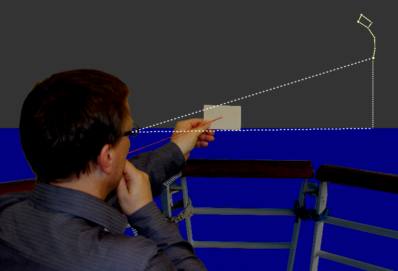
Arab sailors navigating across the Indian Ocean had no octants or sextants. They had a 'Kamal', which consisted of a rectangular wooden plate, roughly the size of a cigarette packet. A length of string was fastened to it and had knots tied on it towards the end. A knot was held between their teeth and the Kamal was held vertically such that the string was stretched. Holding the bottom edge of the Kamal on the horizon, the height of Polaris was estimated in finger widths. The 'pilot book' would say, for example, to go to Calcutta "Go South until Polaris at two fingers and then turn East for five days when you will meet a change of current direction..."

Kamal_Polaris.png
 

Daydream believer

Well-known member
Joined
6 Oct 2012
Messages
19,463
Location
Southminster, essex
Visit site
Talking about fingers and angles.
Arab sailors navigating across the Indian Ocean had no octants or sextants. They had a 'Kamal', which consisted of a rectangular wooden plate, roughly the size of a cigarette packet. A length of string was fastened to it and had knots tied on it towards the end. A knot was held between their teeth and the Kamal was held vertically such that the string was stretched. Holding the bottom edge of the Kamal on the horizon, the height of Polaris was estimated in finger widths. The 'pilot book' would say, for example, to go to Calcutta "Go South until Polaris at two fingers and then turn East for five days when you will meet a change of current direction..."

Kamal_Polaris.png
And there was me thinking that the helmsman used to stand naked with his legs apart. The ship would head North or south. When the swell changed,, indicating a different latitude , he noticed the swing change in the nether regions . At that point he would turn east or west.
 
Top