simonjk
Well-known member
*****
PERFECT CHRISTMAS PRESENTS FROM WEATHER SCHOOL...
Take a look at my books and DVD's, ideal for Christmas, see free samples online at http://www.weatherweb.net/books.htm
*****
Hello,
A mixed weekend of sailing weather to come, but I think most of us should be able to sneak something in. It's western and southwestern coasts that leave me most in doubt, it could be fairly murky here all weekend.
For those of you who have asked about Weather School dates for early 2012, I am finalising them at the moment and will let you know asap.
I'm pleased so many of you like the videos and thanks for the feedback about these.
The Sailing Weather Information Service is available too at http://www.sailingweather.co.uk with frequently updated forecasts. You can get a 14-day free trial by visiting the website and registering. Forecast can be viewed on the web, by email and even by text message to your mobile telephone.
Now on with the weekend forecast, and any friends or colleagues who want to receive this forecast can do so by emailing sailingweather-subscribe@weatherweb.net
Have a great weekend,
Best wishes,
Simon
WEEKEND WEATHER FORECAST
==========================
Issued: 1000 Thursday 10th November 2011
SATURDAY:
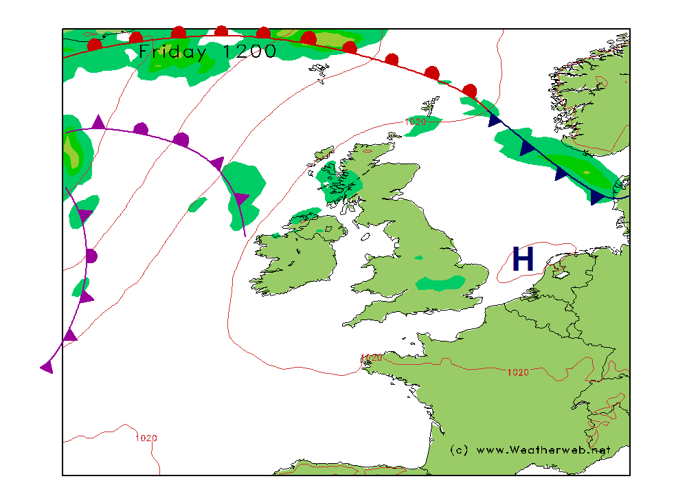
A frontal system is going to be trailing through southeast and southern parts of England through Saturday. The warm front will be moving steadily northwards on Saturday afternoon, whilst the cold front weakens as it moves away southeastwards.
Ity is likely to be a cloud, misty morning across southern parts of England with some outbreaks of drizzle at times. Low cloud is likely to be a probably too with moderate or poor visibility.
Further north through central and northern England, Wales, Scotland and most of Ireland cloud is likely to be more broken. There could be a few isolated morning mist and fog patches but these should be clearing fairly quickly to leave bright spells.
As the warm front moves north in the afternoon cloud is going to be thickening across the southern half of England and Wales, bringing an increasing threat of lowering cloud and rain. Most of this is likely over south Wales, southwest and southern coasts of England (east of the Isle of Wight), although drizzle and deteriorating visibility could affect almost anywhere over central and southern England.
Northern Ireland and Scotland as well as the far north of England stay with the best conditions of broken cloud and sunny spells. Only an odd shower over northwest Scotland.
Winds S-SE 10-16kt (F3-F4) but increasing 15-19kt (SE F5) in Ireland and western parts of England and Wales through the afternoon.

SUNDAY:
A brisk southeast flow through the country throughout the day on Sunday. A warm front is going to be affecting northern parts of Scotland, this clearing northwards.
Probably a fairly dull and murky start to the morning across much of the country. Low cloud and some spots of drizzle are likely, especially over the Pennines, with the chance of more persistent rain across Scotland.
Drier air is likely to be arriving in the south during the day and this will have the effect of lifting the cloud bases, improving visibility and eventually causing the cloud to break. However, the far north of Scotland may stay fairly dull and drizzle, with more low cloud and some drizzle over southern Ireland too.
Winds will be SE 12-15kt (F4) in the east, but 18-24kt (F5-F6) in the west.

**ends**
PERFECT CHRISTMAS PRESENTS FROM WEATHER SCHOOL...
Take a look at my books and DVD's, ideal for Christmas, see free samples online at http://www.weatherweb.net/books.htm
*****
Hello,
A mixed weekend of sailing weather to come, but I think most of us should be able to sneak something in. It's western and southwestern coasts that leave me most in doubt, it could be fairly murky here all weekend.
For those of you who have asked about Weather School dates for early 2012, I am finalising them at the moment and will let you know asap.
I'm pleased so many of you like the videos and thanks for the feedback about these.
The Sailing Weather Information Service is available too at http://www.sailingweather.co.uk with frequently updated forecasts. You can get a 14-day free trial by visiting the website and registering. Forecast can be viewed on the web, by email and even by text message to your mobile telephone.
Now on with the weekend forecast, and any friends or colleagues who want to receive this forecast can do so by emailing sailingweather-subscribe@weatherweb.net
Have a great weekend,
Best wishes,
Simon
WEEKEND WEATHER FORECAST
==========================
Issued: 1000 Thursday 10th November 2011
SATURDAY:
A frontal system is going to be trailing through southeast and southern parts of England through Saturday. The warm front will be moving steadily northwards on Saturday afternoon, whilst the cold front weakens as it moves away southeastwards.
Ity is likely to be a cloud, misty morning across southern parts of England with some outbreaks of drizzle at times. Low cloud is likely to be a probably too with moderate or poor visibility.
Further north through central and northern England, Wales, Scotland and most of Ireland cloud is likely to be more broken. There could be a few isolated morning mist and fog patches but these should be clearing fairly quickly to leave bright spells.
As the warm front moves north in the afternoon cloud is going to be thickening across the southern half of England and Wales, bringing an increasing threat of lowering cloud and rain. Most of this is likely over south Wales, southwest and southern coasts of England (east of the Isle of Wight), although drizzle and deteriorating visibility could affect almost anywhere over central and southern England.
Northern Ireland and Scotland as well as the far north of England stay with the best conditions of broken cloud and sunny spells. Only an odd shower over northwest Scotland.
Winds S-SE 10-16kt (F3-F4) but increasing 15-19kt (SE F5) in Ireland and western parts of England and Wales through the afternoon.

SUNDAY:
A brisk southeast flow through the country throughout the day on Sunday. A warm front is going to be affecting northern parts of Scotland, this clearing northwards.
Probably a fairly dull and murky start to the morning across much of the country. Low cloud and some spots of drizzle are likely, especially over the Pennines, with the chance of more persistent rain across Scotland.
Drier air is likely to be arriving in the south during the day and this will have the effect of lifting the cloud bases, improving visibility and eventually causing the cloud to break. However, the far north of Scotland may stay fairly dull and drizzle, with more low cloud and some drizzle over southern Ireland too.
Winds will be SE 12-15kt (F4) in the east, but 18-24kt (F5-F6) in the west.

**ends**
