The Black Deep and the PLA General Directions - Update

prestomg27

Active member
Joined
24 May 2023
Messages
200
Visit site
'Tis better to ask for forgiveness than ask for permission, maybe my approach here.

If they call me up after transiting next year I fear I will either copy that old comedian whose act contained mainly static interjected with 'sorry' buzz buzz whistle whistle, 'can you say again' crackle crackle, 'must dash' fizz fiz; or, just plead ignorance.


p.s. they don't read this nonsense do they?
 

DanTribe

Well-known member
Joined
8 Jan 2002
Messages
5,458
Location
Essex
Visit site
I note BBC news is reporting that Maersk will transfer operations form Felixstowe to London Gateway.
I assume this will affect traffic patterns. in Black Deep?
 

Poecheng

Well-known member
Joined
16 Aug 2013
Messages
2,225
Location
East Coast
Visit site
I know this very incident well (for reasons not for the forum) and have read the report carefully.
Merely identifying a collision between yacht and ship does not engage with the point under discussion, nor does a single, tragic incident mean ipso facto we all have to change behaviours (as I will develop).
To be relevant to this discussion, root cause analysis of that incident would need to show that a phone call or VHF call to Harwich VTS and consequential permission for the yacht to be in the channel would or might have made a difference. There is no such conclusion to my recollection. The yacht in this instance was aware of the presence of the ship. Granting a yacht permission to enter an area does not mean that the ship will conduct itself properly.

What is the implication behind raising this incident in this discussion? Is it that no outer limits of ports or their approaches may be entered by yachts absent permission of the harbourmaster? That was not the conclusion of the report, has not been adopted in Harwich and is overreach on a massive scale.
It is one thing contacting the port in order to enter the port or even crossing the entrance though, for example crossing the entrance to Zeebrugge requires no such communications (though VTS may contact you if they wish, which is quite different).

Putting bad visibility to one side, Black Deep appears to me to be straightforward for a yacht safely to navigate. The width is clear, the direction of the shipping is clear, it is well bouyed. You know where you are and that you are potentially in there with the big ships (though fairly rarely in my limited experiene). It is not the Westerschelde where they are coming from all angles plus the crazy fishing boats. The only issue is the speed of the ships and keeping an eye/AIS/radar lookout as appropriate. Seems to me a fairly straightforward place to be but needing to be in alert mode (ie more than normal). Precautions are one thing but the potential to be denied permission to even cross Black Deep (not just wait a bit, but permission denied) is frankly absurd. They don't own it !
 

Sailing steve

Well-known member
Joined
4 Apr 2021
Messages
334
Visit site
In general the British are far too complaint in acquiescing to the wants/needs/demands of commercial organisations.

Perhaps it's time to become more like our French cousins who when faced with said wants/needs/demands from commercial organisations to the detriment of their own freedoms to act as they please would react by a mass protest from hundreds of leisure craft anchoring in or repeatedly sailing up and down the Black Deep effectively closing it off to commercial traffic altogether.
 

westhinder

Well-known member
Joined
15 Feb 2003
Messages
2,545
Location
Belgium
Visit site
@tillergirl thank you very much for your efforts.
When crossing from Nieuwpoort to Harwich and vice versa via Long Sand Head I normally monitor Sunk VTS when in the vicinity of Long Sand Head. Does the new rule mean that London VTS should also be monitored and asked for permission? My normal course would take me just east of the red ‘Black Deep’ buoy, so would that be technically outside the Black Deep and outside the authority of the PLA?
 

PeterWright

Well-known member
Joined
23 Aug 2006
Messages
1,165
Location
Burnham-on-Crouch, UK
Visit site
I note BBC news is reporting that Maersk will transfer operations form Felixstowe to London Gateway.
I assume this will affect traffic patterns. in Black Deep?
Hi Dan,

I'm sure it will. The change, which will take effect from the coming February, Applies to the Maersk / Hapag Lloyd Gemini cooperation, which covers their larger ships, so we can expect more of these giants in Black Deep from that date. I guess this will be balanced by a similar reduction of the same ships going in and out of Felixstowe. The headline below is so much paraphrased it contradicts the article, not unusual in today's sloppy click bait driven journalism.

Shipping giant Maersk to cease Port of Felixstowe operation

Peter.
 

tillergirl

Well-known member
Joined
5 Nov 2002
Messages
8,552
Location
West Mersea
Visit site
@tillergirl thank you very much for your efforts.
When crossing from Nieuwpoort to Harwich and vice versa via Long Sand Head I normally monitor Sunk VTS when in the vicinity of Long Sand Head. Does the new rule mean that London VTS should also be monitored and asked for permission? My normal course would take me just east of the red ‘Black Deep’ buoy, so would that be technically outside the Black Deep and outside the authority of the PLA?

Another reader has asked the same question. I would need to delve back into the other documents to be specific to define the 'Black Deep'. But the 'Black Deep' PHB is outside the PLA Pilotage Area so the General Directions cannot apply (as far as I can see). Frankly this is going to get a much busier corner in the years ahead. Perhaps it is me given how many have posted here not seeing traffic! The only time I think when I didn't see ships there was the Covid year (and London VTS called me up there, probably a bit bored!). But then I do tend to be there for 3 to 4 hours whereas most don't linger, just cross and a Container ship will have passed away from Fisherman's Gat from the Black Deep PHB in 40 minutes.

Despite this being out of the PLA Pilotage Area, my response to the reader was, 'call up the PLA'. My argument is just that it is very simple to call up and this is going to be a busy corner. Maersk (as above) have announced that their Felixstowe traffic will now go to the London Gateway and in consequence the 'Two-Way' corner and the Sunk Inner Precautionary Zone are going to get busy. You will be crossing the Two-way channel, the Trinity DW channel and the Sunk DW channel in a span of 5/6NM of water (the Trinity and Sunk DW channels feed into the Black Deep DW Channel). If you approached the Long Sand Head and saw a ship outbound in the Black Deep it would be really handy to know the ship's intentions: you would consider your actions dependent upon which 'exit' the ship intends. There are other scenarios that could benefit you. I think also that London VTS would appreciate being told of your intentions AND I am sure any Pilot in the area would appreciate your intentions.
 

crawlerm

New member
Joined
13 Sep 2010
Messages
7
Visit site
@tillergirl - thanks for your efforts on this. Two questions to pester you further:

1. I had, wrongly, thought that Sunk VTS monitored Black Deep. This is probably because some years ago I was accompanying another yacht at the Sunk Head and they, being fitted with AIS, were contacted by SUNK VTS and told to keep to the edge of the channel. I was monitoring #14, unlike them, so heard the call. Now I think that I should have been on #69. So, is SUNK VTS only responsible for the Sunk scheme and not Black Deep? On the chart, the PLA area runs from the Naze to North Foreland so only goes as far North as Fisherman's and southbound traffic is from the Sunk area. It does not quite fit together, have there been some changes brought about by the recently upgraded VTS system?

2. A non-navigational question: Who was Foulger? From Imray C1 charts, the channel only seems to have been buoyed and marked as such since 2002. Not important but it would be good to know.
 

DanTribe

Well-known member
Joined
8 Jan 2002
Messages
5,458
Location
Essex
Visit site
@tillergirl - thanks for your efforts on this. Two questions to pester you further:

1. I had, wrongly, thought that Sunk VTS monitored Black Deep. This is probably because some years ago I was accompanying another yacht at the Sunk Head and they, being fitted with AIS, were contacted by SUNK VTS and told to keep to the edge of the channel. I was monitoring #14, unlike them, so heard the call. Now I think that I should have been on #69. So, is SUNK VTS only responsible for the Sunk scheme and not Black Deep? On the chart, the PLA area runs from the Naze to North Foreland so only goes as far North as Fisherman's and southbound traffic is from the Sunk area. It does not quite fit together, have there been some changes brought about by the recently upgraded VTS system?

2. A non-navigational question: Who was Foulger? From Imray C1 charts, the channel only seems to have been buoyed and marked as such since 2002. Not important but it would be good to know.
Brian Foulger, well known East Coast yachtsman and offshore racer and general Good Bloke. Previous owner of the beautiful varnished Alish III and later Shilia, a Seastream 34. He was a frequent explorer of the estuary and was credited with rediscovering the swatchway later named Foulgers Gat.
Not sure of the dates but about 1980s? ish.
 
Last edited:

tillergirl

Well-known member
Joined
5 Nov 2002
Messages
8,552
Location
West Mersea
Visit site
#29

Sunk VTS is responsible for the Sunk area: London VTS covers the Black Deep. Yuo are right about the seaward limit of the PLA but the PA has an extension of its Pilotage Area which covers most of the Black Deep. The two VTS do not have coterminus borders (is that the right word?), actually bits overlap. The PLA Pilotage area starts where the seaward limit ends from the Old Gunfleet Light house just on the south of the east side of the new East Long Sand Head cardinal and returning back along the southeast side of the Long Sand. So the 'Black Deep' PBH buoy is outside of the PLA Pilotage area. Matters are simplified :ROFLMAO: by the Sunk scheme area whichuses the Black Deep PHB as a limit mark. the east side of Sunk scheme runs north up the west side of the Two-Way route up to the East Cardinal at the Long Sand head, across to and pass by the Black Deep PHB to an unmarked limit which turns NW towards the SW corner of the Sunk Inner ships anchorage. Thus, as you all know, 👨‍🎓 there is a triangular area of dual sovereign responsibility. I shall be asking questions tomorrow morning.

I ought to be serious. The PLA Pilotage Area has been in force for over 24 years but the Black Deep proviso was not created at the same time; much more recent but I am not sure exactly when - 2019?. Using a chart plotter to identify such limits are a challenge. In that area there is a small multitude of dotted magenta lines. I am not quite sure how I thought it interesting today to look at the way in two different chart plotters both using Navionics. First point. There is no caution on Navionics about the Black Deep until on plotter 1 is zoomed down of 0.8nm. That says 'Draught restrictions - see lower zooms'. At 0.6nm it says the same. Then at 0.4nm it says about the draught of 6m restriction. Any further zoom has the same. There is no mention of the requirement for permission and says 'Normally restricted to vessels with a draught of over 6 metres. Consult London VTS for further detail'. Plotter 2 shows no warning until 500m zoom when it has just 'Draught restrictions (see lower zooms)'. One step down to 250m gets the same more full instructions.

So using a chart plotter at say 5 or 2km step for passage planning anyone would be ignorant of the requirement. And as for an app! (I was going to add '.................' but the Moderators would ban me so I didn't :giggle: )

Date of Foulger's Buoyage. Not sure myself. It wasn't buoyed in 1987 but actually the Black Deep No 6 PHB marked (accidentally?) the northern entrance of Foulger's. Janet's East Coast Rivers shows the two SWBs in Foulgers Gat (using the name for the first time) in 2003. Janet may be tell us more on the history.
 

crawlerm

New member
Joined
13 Sep 2010
Messages
7
Visit site
Brian Foulger, well known East Coast yachtsman and offshore racer and general Good Bloke. Previous owner of the beautiful varnished Alish III and later Shilia, a Seastream 34. He was a frequent explorer of the estuary and was credited with rediscovering the swatchway later named Foulgers Gat.
Not sure of the dates but about 1980s? ish.
Thanks, I've now had a look at old posts so have the background. It's interesting how rapidly the swatch appeared, from less than 2' to 11' in less than fifty years. The buoys and name appeared on 2002 Imray C1; I have not found anything earlier.
 

tillergirl

Well-known member
Joined
5 Nov 2002
Messages
8,552
Location
West Mersea
Visit site
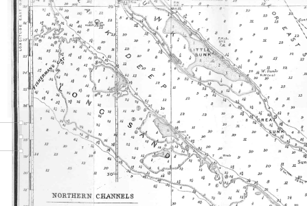
1928 - the gap was there and the 2+ refers to fathoms. I think the 2' you refer to fifty years ago might have been a fathoms chart. But In 1903 and 1908 there was no defined gap, indeed right at the place of today's entrance, it dries 12 foot! Note the Little Sunk opposite dried 5 foot rather than 3m at chart datum today. The sands are always alive.

1732285885214.png
 

MikeBz

Well-known member
Joined
22 Aug 2005
Messages
1,575
Location
East Anglia
Visit site
1928 - the gap was there and the 2+ refers to fathoms. I think the 2' you refer to fifty years ago might have been a fathoms chart. But In 1903 and 1908 there was no defined gap, indeed right at the place of today's entrance, it dries 12 foot! Note the Little Sunk opposite dried 5 foot rather than 3m at chart datum today. The sands are always alive.

View attachment 185732
Were charts “West up” in those days or has my mind completely gone?
 

Jan Harber

Active member
Joined
8 Nov 2009
Messages
298
Visit site
#29

Sunk VTS is responsible for the Sunk area: London VTS covers the Black Deep. Yuo are right about the seaward limit of the PLA but the PA has an extension of its Pilotage Area which covers most of the Black Deep. The two VTS do not have coterminus borders (is that the right word?), actually bits overlap. The PLA Pilotage area starts where the seaward limit ends from the Old Gunfleet Light house just on the south of the east side of the new East Long Sand Head cardinal and returning back along the southeast side of the Long Sand. So the 'Black Deep' PBH buoy is outside of the PLA Pilotage area. Matters are simplified :ROFLMAO: by the Sunk scheme area whichuses the Black Deep PHB as a limit mark. the east side of Sunk scheme runs north up the west side of the Two-Way route up to the East Cardinal at the Long Sand head, across to and pass by the Black Deep PHB to an unmarked limit which turns NW towards the SW corner of the Sunk Inner ships anchorage. Thus, as you all know, 👨‍🎓 there is a triangular area of dual sovereign responsibility. I shall be asking questions tomorrow morning.

I ought to be serious. The PLA Pilotage Area has been in force for over 24 years but the Black Deep proviso was not created at the same time; much more recent but I am not sure exactly when - 2019?. Using a chart plotter to identify such limits are a challenge. In that area there is a small multitude of dotted magenta lines. I am not quite sure how I thought it interesting today to look at the way in two different chart plotters both using Navionics. First point. There is no caution on Navionics about the Black Deep until on plotter 1 is zoomed down of 0.8nm. That says 'Draught restrictions - see lower zooms'. At 0.6nm it says the same. Then at 0.4nm it says about the draught of 6m restriction. Any further zoom has the same. There is no mention of the requirement for permission and says 'Normally restricted to vessels with a draught of over 6 metres. Consult London VTS for further detail'. Plotter 2 shows no warning until 500m zoom when it has just 'Draught restrictions (see lower zooms)'. One step down to 250m gets the same more full instructions.

So using a chart plotter at say 5 or 2km step for passage planning anyone would be ignorant of the requirement. And as for an app! (I was going to add '.................' but the Moderators would ban me so I didn't :giggle: )

Date of Foulger's Buoyage. Not sure myself. It wasn't buoyed in 1987 but actually the Black Deep No 6 PHB marked (accidentally?) the northern entrance of Foulger's. Janet's East Coast Rivers shows the two SWBs in Foulgers Gat (using the name for the first time) in 2003. Janet may be tell us more on the history.
I’m afraid I can’t tell you much more about the history of Foulgers Gat except that, as you say, we first included it in the 2003 edition ECR, published at that time by Nautical Data. I believe it was actually buoyed for the first time in 2002.
However, with apologies for slight thread drift, I do have more info on Brian Foulger and his trio of boats named Ailish. Brian was chairman of the EAORA from 1978 to 1981. His first Ailish was a Philip Rhodes-designed 28-footer built in Scotland in 1963. Ailish 11 was the fourth S&S34 to be completed by Priors of Burnham for various East Anglian sailors, including Brian, following the success in 1969 of Ted Heath’s S&S34 Morning Cloud. The beautifully-varnished Ailish 111 was a Dick Carter-designed One Tonner built by Clare Lallow in 1974 as Eleuthera but re-named by Brian when he bought her, in time to take part in the ‘79 Fastnet. In Plymouth afterwards, having come through relatively unscathed, Brian is reported to have commented that “it was a bit choppy!” There is a photo of Ailish 111 on her mooring at Burnham in the 1981 edition of ECR.
Brian related many EAORA anecdotes to Jan Wise and they can be found recorded in her little book 50 Years of East Anglian Offshore Racing (2001).
The Seastream Shelia (Ailish backwards) was, I imagine, Brian’s last boat and is possibly the one he was sailing, I’m guessing in the ‘90s, when he started using the Gat that now bears his name? Presumably allocated by the Admiralty/Hydrographers at that time?
 

tillergirl

Well-known member
Joined
5 Nov 2002
Messages
8,552
Location
West Mersea
Visit site
Were charts “West up” in those days or has my mind completely gone?
Yeap! I think t'were the Dutchman Wagenhaer (spelling?) who started it. The Pilot's Guide for River Thames 1908 are all 'west side up' and then it all seemed to start changed to 'north side up' after that. Aiming at London? No idea why it changed. Reynold's Yachtsman's 1903 chart is 'north side up'
 
Last edited:

AntarcticPilot

Well-known member
Joined
4 May 2007
Messages
10,610
Location
Cambridge, UK
www.cooperandyau.co.uk

Yeap! I think t'were the Dutchman Wagenhaer (spelling?) who started it. The Pilot's Guide for River Thames 1908 are all 'west side up' and then it all seemed to start changed to 'north side up' after that. Aiming at London? No idea why it changed. Reynold's Yachtsman's 1903 chart is 'north side up'
Well, our maps of Antarctica had 'North every direction" - the South Pole was at the centre of the map! The convention for maps of the continent was Greenwich meridian up.
 

johnalison

Well-known member
Joined
14 Feb 2007
Messages
41,106
Location
Essex
Visit site
Oh, that was simple then!

Blimey. Just noted there was 15 degrees of variation in 1908! And the Spitway is east of Clacton! (i.e. where the NE corner of the Gunfleet WF is located)
Yes, I think my older books such as Alker Tripp showed the Spitway far to the east. I got the impression that it was a different gap rather than one that later moved. I can imagine the rejoicing at the Colne YC when the shorter route opened up.
 
Top