Positions is the 3rd Decimal necessary?

capnsensible

Well-known member
Joined
15 Mar 2007
Messages
43,923
Location
Atlantic
Visit site
Demands for such extreme and unnecessary precision are usually an indication of a system that has lost touch with its practical roots and has been taken over by unthinking bureaucrats/technogeeks rather than practically-minded people who actually understand the job.
Surely no-one would ever describe the CG in such terms?
Radiocommunication Study Groups

Get on in there and give it to them, the know all so called experts.
 

capnsensible

Well-known member
Joined
15 Mar 2007
Messages
43,923
Location
Atlantic
Visit site
I'm thinking that for the circumstance outlined in the OP in the other thread - i.e. the challenge of taking down and locating a position given by Coastguard in Lat/Long to see if it is of any relevance to the listener - one could ignore the decimals entirely. The minutes of a degree will suffice for that purpose.

In the extremely unlikely event that you find on checking that -
(a) you are close to the thing referred to; AND
(b) you could help or it is a danger to you; AND
(c) you can't actually see it;
you could ask the Coastguard to give the full position again.
I reckon that's the problem. Who, these days, is used to routinely plotting positions on charts in the leisure sailing world?

Don't really have to with modern navaids so the practice is lost. As well as sensible interpretation of radio messages.....
 

lustyd

Well-known member
Joined
27 Jul 2010
Messages
11,415
Visit site
Demands for such extreme and unnecessary precision are usually an indication of a system that has lost touch with its practical roots and has been taken over by unthinking bureaucrats/technogeeks rather than practically-minded people who actually understand the job.
Like the people who may need to work out your position based on tidal currents as accurately as possible to rescue you? A few metres might not matter if you're being rescued at that very moment, but if you give a couple of reports a few minutes apart and then lose power or the radio breaks, or any number of other things then I should imagine the emergency services will be very glad of every bit of detail they can get.

I realise this thread is mostly old men shouting at clouds, but it surprises me that anyone would be against the standard practices put in place by and for our emergency services and rescue teams, just because they personally don't understand them.
 

oldmanofthehills

Well-known member
Joined
13 Aug 2010
Messages
4,854
Location
Bristol / Cornwall
Visit site
That third decimal place is there so the miltary can get a missile in through a bunker window or at least hit the middle of the building. Was originally not available to us yotties, but now its there we all use it.

If course the charts are out by a bit, the map baseline is wrong, and your nav system can get confused in it interpretation at start up and then need to adjust so you seem to leap about 20m sideways
 

AntarcticPilot

Well-known member
Joined
4 May 2007
Messages
10,160
Location
Cambridge, UK
www.cooperandyau.co.uk
Yes my brain fart which only makes my point clearer.

.

When the accuracy is down to meters or less I think you will find there is a whole new world of pain required. The WGS84 datum is not good enough. All to do with the world not being uniformly round.
WGS84 is good to centimetre accuracy; it's what we used for surveying to that accuracy in the Antarctic. It's predecessor, WGS72, was good to metres. Millimeter accuracy gets tricky; you need a new datum almost every year (look up ETRF datums). But only people studying plate tectonics or setting up long baseline interferometry need that kind of accuracy.
 

B27

Well-known member
Joined
26 Jul 2023
Messages
1,425
Visit site
In instrumentation, it's generally good to have an extra decimal place which you don't need, but you can use to see if the reading is changing, which not only tells you you're drifting a bit, it reassures you that the data is 'live'.
You should always regard the last digit as +/- 1, so if .01 minutes is 20m, you'd be making every channel marker a 40m circle and your track 40m wide. That's fine in mid Atlantic, not good enough for getting a ship into Pompey?
 

lustyd

Well-known member
Joined
27 Jul 2010
Messages
11,415
Visit site
That's fine in mid Atlantic, not good enough for getting a ship into Pompey?
That’s why they use transits and sector lights to get into Pompey 😂 I’m sure the aircraft carriers have some of the best GNSS in the world but they still turn on those massive lights any time it moves
 

boomerangben

Well-known member
Joined
24 Jul 2003
Messages
1,153
Location
Isle of Lewis
Visit site
In instrumentation, it's generally good to have an extra decimal place which you don't need, but you can use to see if the reading is changing, which not only tells you you're drifting a bit, it reassures you that the data is 'live'.
You should always regard the last digit as +/- 1, so if .01 minutes is 20m, you'd be making every channel marker a 40m circle and your track 40m wide. That's fine in mid Atlantic, not good enough for getting a ship into Pompey?
Do you not look out when navigating in confined areas? I’m pretty sure than anyone going in and out of Pompey is going to have the mark 1 eyeball looking at what they might hit in the real world rather than an icon and its third decimal place in the digital one.
 

Mark-1

Well-known member
Joined
22 Sep 2008
Messages
4,043
Visit site
I’m sure the aircraft carriers have some of the best GNSS in the world

Raises an interesting question. As we know, mobile phones and Marine GNSS likely have GPS, GLONASS, Beidou and Galeleio combined on the same chip. That must result in a more accurate, faster and reliable fix than any individual network.

There's no permanant SA any more.

So... Does a NATO Aircraft Carrier use Russian and Chinese GNSS in addition to GPS and Galileo? ...and if, as I suspect, not, is my phone more accurate than the GNSS on a Warship?

I guess the question is, is very clever/sensitive Antenna/Hardware on one or two networks more effective than multiple networks combined?

I'd love to know.

It would amuse me if leisure boats and teenagers have better GNSS than the world's most expensive and sophisticated ships. (Unless there's a war and everyone turns SA on, obvs.)
 

Frank Holden

Well-known member
Joined
23 Nov 2009
Messages
991
Location
Cruising in the Golfo Corcovado
Visit site
If you are using the 3rd decimal place when going into Pompey the distance moved since reading the number , putting it on the paper chart, and processing it in your brain will reduce the accuracy to 2 decimal places or worse anyway. Which is why we use plotters.
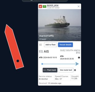
Big ship offsets on AIS? Best you don't try to pass close ahead of this ship based on an AIS CPA. She is 333 metres , 50 metres beam.marjan.jpg
 

GHA

Well-known member
Joined
26 Jun 2013
Messages
12,289
Location
Hopefully somewhere warm
Visit site
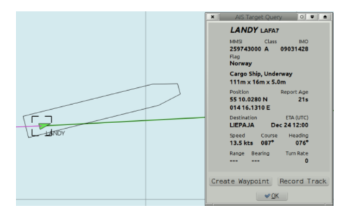
When installing an AIS class B+ transponder, you have to enter the offset of the GPS antenna from the centre of the boat. Obviously for most of us that's a number down in the noise of the GNSS position, but I guess it must be an issue for small commercial vessels!
Opencpn can show the AIS target actual size & where the AIS message says the GPS is, not something anyone would really want to get so close to use but nice programming touch >
1718055173064.png
 

B27

Well-known member
Joined
26 Jul 2023
Messages
1,425
Visit site
That’s why they use transits and sector lights to get into Pompey 😂 I’m sure the aircraft carriers have some of the best GNSS in the world but they still turn on those massive lights any time it moves
I suspect the lights and stuff are mostly so the pilot can check the 'puter is doing the right thing?
With ships this is not just about steering the boat in real time, but also data recorders.

Do the navy stay at home if it's foggy? The professionals on the car ferries don't....
 

jlavery

Well-known member
Joined
25 Oct 2020
Messages
560
Visit site
I suspect the lights and stuff are mostly so the pilot can check the 'puter is doing the right thing?
With ships this is not just about steering the boat in real time, but also data recorders.

Do the navy stay at home if it's foggy? The professionals on the car ferries don't....
They use the transits and do it by eye. All explained very well in this video.
 

B27

Well-known member
Joined
26 Jul 2023
Messages
1,425
Visit site
Raises an interesting question. As we know, mobile phones and Marine GNSS likely have GPS, GLONASS, Beidou and Galeleio combined on the same chip. That must result in a more accurate, faster and reliable fix than any individual network.

There's no permanant SA any more.

So... Does a NATO Aircraft Carrier use Russian and Chinese GNSS in addition to GPS and Galileo? ...and if, as I suspect, not, is my phone more accurate than the GNSS on a Warship?

I guess the question is, is very clever/sensitive Antenna/Hardware on one or two networks more effective than multiple networks combined?

I'd love to know.

It would amuse me if leisure boats and teenagers have better GNSS than the world's most expensive and sophisticated ships. (Unless there's a war and everyone turns SA on, obvs.)
Military GPS has access to more data in the code and also additional frequencies which AIUI help correct for atmospheric effects etc.
The GNSS in your phone probably isn't as good at the military stuff at altitude and mach 3.
 
Top