Paper Charts?

ColourfulOwl

Member
Joined
10 Sep 2022
Messages
53
Location
Fleetwood Beacon Marina
www.colourfulowl.com
I'm currently planning and preparing my boat to do a circumnavigation around Britain in 2025. Yes I know, a future plan xD

As apart of the planning I've been reading through Sam Steele's Circumnavigation's Guide to the UK and Ireland. The book was original written in 2008 and updated in 2011. I'm reading the second edition. It's brought up during the financial section how much they spent on buying paper charts to cover the whole of the UK.

Which raises the question, in 2024, for those who are liveaboards, do you still buy paper charts for the places that you are planning on going to?

I have paper charts for my local sailing grounds, being the Irish sea, and I can't really say I've ever used them all that much. At first I did, purely out of habit from the day skipper course, but after a few passage I haven't really looked at them since. Now I primarily relay on Navionics, Savvy Navvy and Orca for my planning. And then I have 2 Garmin chartplotters on my boat, both with full UK charts, that I use as auxiliary plans - I always set up a similar route to my apps on these chart plotters so if my tablet and phone died I'd still have a third and forth backup.
 

GHA

Well-known member
Joined
26 Jun 2013
Messages
12,412
Location
Hopefully somewhere warm
Visit site
Not sure I know any cruisers who still use paper, though most probably have enough info in charts or guidebooks to get somewhere safe if needed. Just aren't needed anymore.
Have you got opencpn on a laptop? So useful. Sasplanet has been such a godsend to get satellite images as charts on opencpn. Also has cmap & navionics so nice to check the datums all agree with the satellite positions. Then noforeignland / navily is another huge leap forward, cruising guides are nice for a zoomed out overview but useless for up to date real world info.
Up to date official charts available for opencpn - British Isles 2024 - o-charts shop


OpenCPN Official Site
Track your boat and share information on places to visit
Navily - The most innovative cruising guide
Making mbTiles
 

RunAgroundHard

Well-known member
Joined
20 Aug 2022
Messages
1,984
Visit site
I sail on the West Coast of Scotland and still have my charts and have just brought them home to be updated for next season. Having said that, I use my plotter all the time, so the paper charts are redundant really. I now have a new plotter, hence reliability has increased significantly on the electronic front.

I do not think you need paper charts. I would recommend Raymarine Lighthouse over Navionics. Navionics symbols are stupidly small on their digital charts. Next best, in my opinion, and much lower cost, is a tablet with Memory Maps and a set of UK Admiralty charts in raster format. This is a very low cost option. I use an iPad, but buy low cost second hand iPads. For the West Coast of Scotland buy a set of Antares charts which can be loaded into Memory Map and form part of the zoom in feature using the Admiralty raster charts. Antares charts are very detailed, privately surveyed, digital chartlets of anchorages, passages and bays - mandatory for the west coast.

The below is my backup to my Raymarine Plotter with Lighthouse Charts (Navionics can be loaded on Raymarine plotters): -

Low Cost iPads
Memory Map
Antares Charts

I also have Visit My Harbour on the iPad which is great for tides and harbour details. They also offer navigation software and charts options.

Visit My Harbour

All the best.
 
Last edited:

lektran

Member
Joined
18 Feb 2020
Messages
79
Location
Gosport
Visit site
We haven't touched the paper charts that came with the boat in the 2k miles we've sailed since purchasing. We've been using Navionics, but it has its limitations when zoomed out for larger passage plans. For example I can't see gas fields, wind farms etc when zoomed out beyond the 5nm scale.

To that end we've just subscribed to Imray Explore (£50/yr) with includes digital raster charts along with harbour and passage information from their pilot books. It's still in beta but looks like it should prove useful this season.

I also have opencpn on a raspberry pi but haven't loaded any charts into it yet.

Regards
Scott
 

Sandy

Well-known member
Joined
31 Aug 2011
Messages
21,538
Location
On the Celtic Fringe
duckduckgo.com
I'm currently planning and preparing my boat to do a circumnavigation around Britain in 2025. Yes I know, a future plan xD

As apart of the planning I've been reading through Sam Steele's Circumnavigation's Guide to the UK and Ireland. The book was original written in 2008 and updated in 2011. I'm reading the second edition. It's brought up during the financial section how much they spent on buying paper charts to cover the whole of the UK.

Which raises the question, in 2024, for those who are liveaboards, do you still buy paper charts for the places that you are planning on going to?

I have paper charts for my local sailing grounds, being the Irish sea, and I can't really say I've ever used them all that much. At first I did, purely out of habit from the day skipper course, but after a few passage I haven't really looked at them since. Now I primarily relay on Navionics, Savvy Navvy and Orca for my planning. And then I have 2 Garmin chartplotters on my boat, both with full UK charts, that I use as auxiliary plans - I always set up a similar route to my apps on these chart plotters so if my tablet and phone died I'd still have a third and forth backup.
It really depends on your preference, personally I never leave on a passage without paper charts. I struggle to plan on a screen as I can't write notes on it.

On passage from Peterhead to Plymouth via Dover a few years ago I co-skippered. It was interesting to see that it took us about the same time to passage plan, but my co-skipper constantly had his head in his tablet during the passage. I came to the conclusion that he had not learnt the route when planning.

On a delivery from Faro to Falmouth you had to prize the tablet from the skippers cold wet hands to check where you were! There was no chart plotter onboard.

No, I am not a live aboard but do some long passages.
 

Graham376

Well-known member
Joined
15 Apr 2018
Messages
7,678
Location
Boat on Mooring off Faro, Home near Abergele
Visit site
I like paper charts for planning and discussing the likely route with the crew otherwise I use a chart plotter.

A lot of my charts are quite old, but the land hasn't really moved nor the major marks from my experience unless you navigate down to a metre accuracy.

Land may not move but wind farms have appeared in many areas, making all our UK to Med charts well out of date.
 

GHA

Well-known member
Joined
26 Jun 2013
Messages
12,412
Location
Hopefully somewhere warm
Visit site
Interesting the different views 😊 Reckon a graph of "Paper or digital" against age would be quite revealing..
Really could never go back to planning on paper, just seems so limiting..

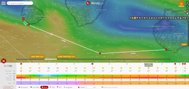
Windy is actually a fairly important part of the process now.. might just be premium but you can do route planning now, it says only ecmf but you can switch to gfs or whatever first then the map will be gfs but the table will still be ecmwf based. Similar for speed, you can add decimals but it only saves as integers. Can be saved to favourites, really useful for "where next I wonder" .
Really useful imho!!.
1706009141572.png

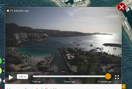
Then if you`re lucky windy will have a link to a local webcam to see how busy the anchorage is.. not very for todays little jaunt round the corner looks like 😎

1706009311576.png


All possible on a mobile waiting in a queue at the supermarket 😎

Plus opencpn makes it so simple to share data now between devices on the same network, click "send to peer" & couple seconds later your route is on tablet, laptop & raspberry pi.

Weather recently gone over to xygrib & set everything to as basic as possible, this is what comes out of the computer models, everything else is colouring in software guesswork, seems to help to remember forecasts will always be a bit vague when zoomed in & local effects can change everything.

1706009798879.png

HTH! 😎
 

Baggywrinkle

Well-known member
Joined
6 Mar 2010
Messages
9,896
Location
Ammersee, Bavaria / Adriatic & Free to roam Europe
Visit site
In 10 years sailing in the med, only got the paper charts out to show crew where we were and where we were going.

The important thing is redundancy, not if you have paper charts or not - although I agree, paper is a back-up that needs no batteries, screens or electrickery at all.

I had multiple sources of electronic charts, on multiple devices. It is always sensible to have a good hand-bearing compass to use in conjunction with electronic charting programs to determine position and plot courses without GPS, a kind of hybrid where all the skills needed for paper navigation are used, but on an electronic representation of the chart - the charting program must be self-contained, requiring only the computer/tablet to be powered up, with no reliance on external data or internet connections.

Explained here ...

Using Electronic Charts without GPS | Cruising Compass
 
Last edited:

doug748

Well-known member
Joined
1 Oct 2002
Messages
13,128
Location
UK. South West.
Visit site
I don't look at charts much when sailing locally, either. On passage they are always on the chart table, you can see a large area, zoom in at will and make notes. A small chart plotter in the cockpit sorts out pilotage.
It's easy, safe and cheap.

As the others have said there are other ways of cracking it. However if I have to spend money, rely on the internet at sea, rent software or have to climb a "steep learning curve", I don't bother.

.
 

GHA

Well-known member
Joined
26 Jun 2013
Messages
12,412
Location
Hopefully somewhere warm
Visit site
As the others have said there are other ways of cracking it. However if I have to spend money, rely on the internet at sea, rent software or have to climb a "steep learning curve", I don't bother.
The software is free, opencpn is a high end navigation program, extremely powerful, charts about 20 quid for official UK.
Internet at sea?? No need for that on passage. Very handy in the anchorage or just pop ashore to happy hour to download latest gribs.
Learning curve is pretty much cast in stone for the individual though genetics & experience, some people find technology simple, others struggle to just find the on button. 🤔
 

IanCC

Active member
Joined
14 Oct 2019
Messages
551
Visit site
I might be missing something, but i don't understand how to do tidal offsets on either my garmin or my tablet.
Can someone tell me how, or is it just expensive?
 

dunedin

Well-known member
Joined
3 Feb 2004
Messages
13,482
Location
Boat (over winters in) the Clyde
Visit site
I like paper charts, but for sailing round Britain would be impractical so wouldn't.
You will need Antares Charts (specialist large scale) for West of Scotland. And these run best on largish screen tablet using Memory Map for All app.
Get this and pay another £25 for the UKHO raster charts for the UK.

A combination of vector charts like Navionics plus raster charts as above give best solution - not least as isolated rocks often very difficult to spot on Navionics, and plenty such hazards in the NW.

Enjoy your trip
 

doug748

Well-known member
Joined
1 Oct 2002
Messages
13,128
Location
UK. South West.
Visit site
The software is free, opencpn is a high end navigation program, extremely powerful, charts about 20 quid for official UK.
Internet at sea?? No need for that on passage. Very handy in the anchorage or just pop ashore to happy hour to download latest gribs.
Learning curve is pretty much cast in stone for the individual though genetics & experience, some people find technology simple, others struggle to just find the on button. 🤔


No need to get defensive, the OP can do whatever he likes.

My present position on Technology is that if it takes more than a few moments to master or set up, I rarely bother.
Good, useful, technology needs no special pleading: VHF, Decca, GPS, AIS, Plotters, Mobile Phones. Much of the rest tends to be zhuzhing up the basic idea, often with diminishing returns. This is great for enthusiasts, but incidental to sailing and, for me, would simply get in the way.

I opened my first computer box in 1985. My maths teacher was a young man, more remarkable than I realized at the time, he taught us binary notation in 1964. Said it was the future.

.
 

Sandy

Well-known member
Joined
31 Aug 2011
Messages
21,538
Location
On the Celtic Fringe
duckduckgo.com
Interesting the different views 😊 Reckon a graph of "Paper or digital" against age would be quite revealing..
An interesting question.

I'm 62 in March, have a engineering degree specialising in electronics, plus some post grad stuff.

After starting work in the world of electronics I quickly moved into Information Technology as it was far more exciting eventually ending up in the world of safety critical systems.

Given all of the above, perhaps because of it, I prefer my primary source to be paper. True, I supplement paper with digital information, but only because that is how the information is published. I refuse to use programmes that do things like course to steer and passage planning as they are currently not intelligent enough. Artificial Intelligence might change that, but as there is no money in developing a system for a few hundred thousand sailors it will be some time before it will be developed; given the number of data points that AI would need to reference for global coverage. Watching some of the UK's MAIB YouTube content some of the commercial systems are good, but from time to time ignored leading to the MAIB getting involved!

As stated in post #5 using in my experience digital tools do not speed up the process of passage planning and the output is poorer quality, e.g. only on one device (perhaps more) and is dependant on wiggly amps to be flowing all the time. We all know Sod's Law of the Sea, 'if something can go wrong, it will'.

A story told by a very young delivery skipper, well much younger than me, was on an owner assisted delivery from the UK to Lanzarote. On day two the owner switched on a rather ancient radar causing a catastrophic electrical failure, no electrics. Thankfully, the delivery skipper had packed her sextant and some basic tables and was able to navigate them to their destination. I look forward to hearing how anybody would sort that out using purely digital means.

Another story, but this time about paper. Arrived in Falmouth in a boat with a 3.30 m draft and the skipper, a Yachtmaster Ocean Examiner, was concerned that we would ground at low water. He trundled off to the marina for the detailed chart and duly returned to the boat. Dropped it on the chart table and invited the crew to inspect it. None of us could see a problem, but there was one. Depths were not tied back to the UKHO chart datum, but referenced a local undefined CD. The skipper returned to the marina office and we gained permission to move to a deeper part of the pontoon.

We still need to be able to do the basics when the amps stop wiggling and challenge all of the data all of the time.
 

GHA

Well-known member
Joined
26 Jun 2013
Messages
12,412
Location
Hopefully somewhere warm
Visit site
An interesting question
My post was not looking at it like that really, but for many over a certain age didn't grow up with technology whereas "the kids" are completely fine with north up vector charts & have no fear of the screen having grown up with the web & google maps.
I hit 60 a few weeks ago (though met loads of people who were much older than me before they hit 30 😂)
Many years were spent in live events including kicking out CAD drawings as the truck was coming to pick up the fabrication so really quickly creating acurrate north up, vector drawings are completely normal, totally at home with all that. Paper's just rubbish for planning for me, ancient. Other people much prefer to work with paper. Not like there's any kind of objective external reality, the illusory world we personally live in is created by our brains so "better" or "worse" are irrelevant personal value judgements really, each to their own.

Also with a deep love of science I tend to go with the data whatever that might be rather than pay too much attention to the biased doom laden fantasies that big monkey brain in my head can come up with. Not too far off 20 years now have been spent living & cruising constantly onboard north & south of the equator there's never ever, not once, been a problem with the toys or power which caused any kind of major calamity. Not true actually, south america is not somewhere to go shopping for boat bits so limped up to the Caribbean from Brasil with batteries struggling to keep the radar running all night. Having a engine which didn't work was much more of a hindrance. Got LiFePo now.

So don't live in fear of monsters from the Id onboard, or rather ignore them 😂 look to the data & the real world.

And with opencpn, noforeignland, sasplanet et al cruising & passage planning has been completely, utterly transformed. So much easier & safer now. Do it anywhere, opencpn is loaded on the phone, tablet, raspberry pi, laptop. Takes about 2 seconds to send routes & waypoints between the different instances over wifi with a right click. Tech works just fine & is reliable and very welcome in my dry boat with constant electricity & spare gadgets stashed but never used.

We all do things the way we like but it's an error to think that "Our way" is some kind of objective & only "right way". We do love to kid ourselves 😂
 

lektran

Member
Joined
18 Feb 2020
Messages
79
Location
Gosport
Visit site
A story told by a very young delivery skipper, well much younger than me, was on an owner assisted delivery from the UK to Lanzarote. On day two the owner switched on a rather ancient radar causing a catastrophic electrical failure, no electrics. Thankfully, the delivery skipper had packed her sextant and some basic tables and was able to navigate them to their destination. I look forward to hearing how anybody would sort that out using purely digital means.

We have two mobile phones and a tablet that all have GPS + navionics and half a dozen cordless tool batteries that can double as USB battery banks. I imagine we would get at least a couple of weeks out of that lot without much difficulty.
 

RunAgroundHard

Well-known member
Joined
20 Aug 2022
Messages
1,984
Visit site
Whatever anyone thinks about paper charts, the reality is that UKHO and other country agencies are withdrawing paper charts.

Within the RYA the discussion is around how to move to electronic navigation: teaching requirements, syllabi, system requirements, standards.

This latter part, standards is a significant part. I do t think that in the leisure industry anyone is suggesting a full ECDIS compliant system but rather what does acceptable look like. Same for the ENC vector charts, what does acceptable look like?

Paper chart withdrawal and cancellation is coming your way, like it or not.
 

Sandy

Well-known member
Joined
31 Aug 2011
Messages
21,538
Location
On the Celtic Fringe
duckduckgo.com
We have two mobile phones and a tablet that all have GPS + navionics and half a dozen cordless tool batteries that can double as USB battery banks. I imagine we would get at least a couple of weeks out of that lot without much difficulty.
An interesting solution to recharging phones. I must look into recharging phone from cordless tool batteries.

Personally, I struggle with charts on phones as I can never see the 'big picture', something that I mentioned in post #5 where my co-skipper had his head constantly in his phone looking at where we were rather than knowing, perhaps I am more of a natural navigator or had built a better picture of the passage in my head.

I use a GPS tracker on my phone when on other vessels as it collects data about a trip that I can use later for my own personal records. Stuffing it into Google earth if a long delivery trip or the Garmin programme if just a local trip.
 

Sandy

Well-known member
Joined
31 Aug 2011
Messages
21,538
Location
On the Celtic Fringe
duckduckgo.com
Whatever anyone thinks about paper charts, the reality is that UKHO and other country agencies are withdrawing paper charts.

Within the RYA the discussion is around how to move to electronic navigation: teaching requirements, syllabi, system requirements, standards.

This latter part, standards is a significant part. I do t think that in the leisure industry anyone is suggesting a full ECDIS compliant system but rather what does acceptable look like. Same for the ENC vector charts, what does acceptable look like?

Paper chart withdrawal and cancellation is coming your way, like it or not.
Thankfully, paper charts will be available for my lifetime, even if the UKHO withdraws paper charts they are not banning Imray and others from producing them.

The problem of no paper charts will be for another generation.

Having worked in the world of writing and maintaining national and international standards I wish the RYA well.
 
Top