Paper Charts?

GHA

Well-known member
Joined
26 Jun 2013
Messages
12,454
Location
Hopefully somewhere warm
Visit site
We have two mobile phones and a tablet that all have GPS + navionics and half a dozen cordless tool batteries that can double as USB battery banks. I imagine we would get at least a couple of weeks out of that lot without much difficulty.
much more than couple of weeks probably. Turn on to get a fix once in a while (like every few days on an ocean passage) to check the passage plan.
Not really that important knowing where you are compared to knowing where you aren't!! 🙂

These have been great to charge phones/tablets. 6-24V DC-DC USB Step Down Buck Converter 12V 24V to 5V 3A Car Charger Module UK | eBay
 
Last edited:

Baggywrinkle

Well-known member
Joined
6 Mar 2010
Messages
10,066
Location
Ammersee, Bavaria / Adriatic & Free to roam Europe
Visit site
Whatever anyone thinks about paper charts, the reality is that UKHO and other country agencies are withdrawing paper charts.

Within the RYA the discussion is around how to move to electronic navigation: teaching requirements, syllabi, system requirements, standards.

This latter part, standards is a significant part. I do t think that in the leisure industry anyone is suggesting a full ECDIS compliant system but rather what does acceptable look like. Same for the ENC vector charts, what does acceptable look like?

Paper chart withdrawal and cancellation is coming your way, like it or not.
It will undoubtedly drive more and more boats to have more screen real-estate for chart displays and weather info, that was the next step for me ... big screen (with big resolution) display.

I even considered replacing the chart table lid with a screen at one point, but I think a big, wide-screen monitor that doubles as a TV for Netflix etc. will be my solution.
 

dansaskip

Well-known member
Joined
12 Nov 2004
Messages
661
Location
Various
seabear.uk
I seem to be in a minority here. It might be my age but I grew up finding my way around using paper maps and then charts and I still won't set out without a set of paper charts. It is not that I am unused to or ignorant of using chart plotters, tablets etc. I was a computer systems engineer so more knowable about computers etc perhaps than your average Joe, and yes I do use navionics on a tablet and a chart plotter too but much prefer paper charts. I can happily be away from electrical power for days and weeks without the need to recharge any devices, running the engine just to recharge the boats batteries or worry about a marina to plug into shore power. Although not strictly relevant. to the op's question of round Britain, when I was crossing the Pacific, two boats that I know off, depending purely on electronic navigation ran into reefs which didn't show when you were zoomed out but were clearly marked on even the largest scale paper chart. In practical terms it is surely easier using a paper chart to find transits, clearing bearings, fix a position using a hand bearing compass and all those old school trick of safe navigating. Or perhaps you don't use those anymore?
So yes if you are happy to be power dependents then stick with your devices. Me I will stick with my paper charts and keep safe when the electrons decide to follow the uncertainty principle.
 

RunAgroundHard

Well-known member
Joined
20 Aug 2022
Messages
2,243
Visit site
… In practical terms it is surely easier using a paper chart to find transits, clearing bearings, fix a position using a hand bearing compass and all those old school trick of safe navigating. …

If you have a plotter, your position is known, so the need for transits, clearing bearings and position lines has gone away in the electronic navigation space.

What you want, transits and position lines, is now available on AngleNav, the development was supported by Tom Cunliffe.

Why I've developed a new navigation app, by Tom Cunliffe

I am not aware of other plotter features to do what you suggest, but position lines, can be measured on a plotter.
 

GHA

Well-known member
Joined
26 Jun 2013
Messages
12,454
Location
Hopefully somewhere warm
Visit site
In practical terms it is surely easier using a paper chart to find transits, clearing bearings, fix a position using a hand bearing compass and all those old school trick of safe navigating. Or perhaps you don't use those anymore?
Nope. Or yes, sometimes just for fun & just check it can still be done. No way could I do it quicker on paper though, I'm much faster & more accurate in opencpn. No need anymore day to day though as the tech has proved itself to be so reliable.

"two boats that I know off, depending purely on electronic navigation ran into reefs which didn't show when you were zoomed out ".
There really isn't an excuse for that, skipper a boat you need to be good at your job & it's a constant education process. How vector charts work on a plotter really isn't any secret, down to the skipper to learn. 100% their fault. Satellite images as charts are pretty much a must have as well now imho to check the charts.

That race boat that ran into a reef near Mauritius had checks & SOP to double check which included having and using satellite images to check the charts but they were in a rush & ignored all that & didn't bother double checking which takes a second or so, then hit a reef. No excuse, poor navigator must still be kicking himself for making such a stupid mistake.
 

capnsensible

Well-known member
Joined
15 Mar 2007
Messages
46,335
Location
Atlantic
Visit site
I recently sailed 640 miles with a chart plotter that didn't work to even half properly and and autopilot that didn't work at all. Both having just been 'repaired' by an 'expert'. Didn't bother us a jot. Got a GPS lat/ long, an Imray chart and....ability to use it.

The super duper all singing all dancing starlink failed at the first financial hurdle too despite a previously researched schedule by the owner so that was adios savvynavvy too.

I personally can live without all that junk and there are many others who can too. Probably because we were taught to navigate in the fall back state and are comfortable with it. Mebbe the gadgeteers are scared of something? Dunno.

But I can use all the electronic stuff too, plotters, radar, etc etc, but not with the same satisfaction as running a manual plot.

I have no gripe with the gadgeteer, far from it. Its enabled many more people to get out there. Personally though I've been trained to back up, and back up your back up! That's up to me. Others may disagree. Fill yer boots.
 

jdc

Well-known member
Joined
1 Dec 2007
Messages
2,016
Location
Falmouth
Visit site
An aspect that is almost never considered when comparing paper with electronic ones is the physical size of the image. (Edit: Baggywrinkle did touch in it).

Who has a screen with super high resolution which is about a metre square? It would need to be that big to compete with a paper chart's functionality (even if the reliability and power requirements were equal). If I had such a screen, electronic charts would be just fine by me, but on a tiny device like a mobile phone or even a chart plotter it's hard to see both detail and the bigger picture simultaneously. So you 'pinch zoom', with the result being no real appreciation as to whether the area covered is now the whole Atlantic Ocean or just a minor creek in Chichester Harbour! So it's not impossible to go all electronic, but it is error prone for that reason.

I think the way forward is to print a chart of the area you want to explore before setting off. I've certainly done that for voyage planning, printing A1 or A2 sheets of where I plan to be. "Not For Navigation" perhaps, but jolly good for the overall picture. You can upload a pdf file and get next-day prints by post from several web sites. That the UKHO can't do this is why they are of decreasing international importance; just about everyone else, including the Americans, can. Besides, if only for planning purposes it's frequently possible to use open databases of shorelines, bathymetry and land topography for which you don't need any HO.

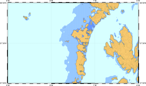
Here is a tiny section of one such (printed to be 30cm across; I'd normally make it more like 100cm across but that would make it too big to be a ybw attachment). Typically I aim for 1:200,000, or there abouts. I'd use such a chart for planning a trip to St Kilda, but not perhaps for transiting the sound of Harris! It's all public domain data, and that data covers the whole globe (In case Antarctic Pilot reads this, I printed such a chart covering the Antarctic peninsula which was excellent - probably he created the data base!).newmap-3.png
 
Last edited:

ColourfulOwl

Member
Joined
10 Sep 2022
Messages
53
Location
Fleetwood Beacon Marina
www.colourfulowl.com
Thanks all for your responses and opinions on this topic. I definitely got what I needed from it :)

I'm not personally going to bother picking up paper charts. Between the amount of electronic backups I have on boards, a constant ability to be connected to the internet (12v starlink + cell boosters) and as a final resort almanacs, I don't really see the value in paper charts. I know there is a legal requirement for commercial vessels to carry them, but from the conversations I've had with commercial skippers most barely look at them and when they do it's purely to update them.
 

capnsensible

Well-known member
Joined
15 Mar 2007
Messages
46,335
Location
Atlantic
Visit site
Thanks all for your responses and opinions on this topic. I definitely got what I needed from it :)

I'm not personally going to bother picking up paper charts. Between the amount of electronic backups I have on boards, a constant ability to be connected to the internet (12v starlink + cell boosters) and as a final resort almanacs, I don't really see the value in paper charts. I know there is a legal requirement for commercial vessels to carry them, but from the conversations I've had with commercial skippers most barely look at them and when they do it's purely to update them.
Indeed you will almost certainly never need them. Like a liferaft.

Good luck and enjoy your cruising. (y)
 

st599

Well-known member
Joined
9 Jan 2006
Messages
7,530
Visit site
If you have a plotter, your position is known, so the need for transits, clearing bearings and position lines has gone away in the electronic navigation space.

What you want, transits and position lines, is now available on AngleNav, the development was supported by Tom Cunliffe.

Why I've developed a new navigation app, by Tom Cunliffe

I am not aware of other plotter features to do what you suggest, but position lines, can be measured on a plotter.
It may have gone away but it's coming back. MCA don't recognise current plotters as meeting the requirements for navigating - hence there's a "Not for Navigation" splash screen on start up. So coded vessels need paper charts.

There's an interesting report on the RIN website about it. They need ability to override the GNSS position with a position from fix.
 

RunAgroundHard

Well-known member
Joined
20 Aug 2022
Messages
2,243
Visit site
It may have gone away but it's coming back. MCA don't recognise current plotters as meeting the requirements for navigating - hence there's a "Not for Navigation" splash screen on start up. So coded vessels need paper charts.

There's an interesting report on the RIN website about it. They need ability to override the GNSS position with a position from fix.

I am fully aware of that having used ECDIS systems. However, ECDIS protocols applied to leisure sailing is utterly pointless for the simple fact that folks are navigating safely all over the place with non ECDIS systems. That is a fact as plain as the nose on the end of your face.

Your argument doesn't wash with me and I couldn't care less about coded vessels. Coded vessels for the leisure industry under a certain length already use a compromised scheme compared to regulations applied to longer commercial vessels, hence the MCA is quite capable of making an analysis and judgment on electronic tools for leisure vessels. I am fully abreast of the current situation.
 

GHA

Well-known member
Joined
26 Jun 2013
Messages
12,454
Location
Hopefully somewhere warm
Visit site
I know there is a legal requirement for commercial vessels to carry them,
Thought it was the opposite? No requirement for any paper with dual ecdis systems? Which kind of echoes the majority of cruisers, the ones I hang out with anyway. Navionics & opencpn installed on various devices with internal GPS's so multiple backups. Same with skippers on the few deliveries I've done, any loss of boat systems is no big deal. And no horror stories of death & destruction. So quick to bang out a passage plan as well. 😎

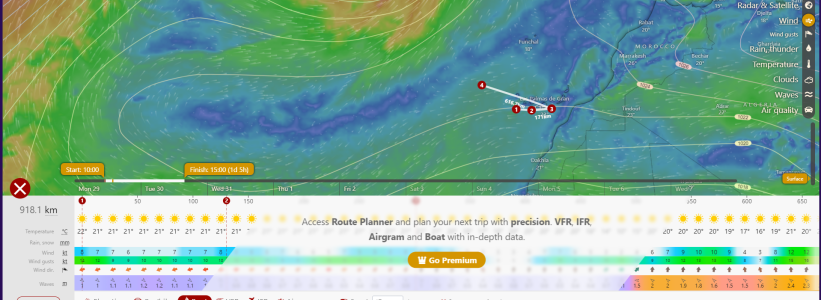
Talking of which.. I've gone over to windy.com now for the initial passage planning & imho is really useful, saves on favourites & you can actually put in speed decimals by hand though it just saves integers. The weather model display can be changed but think maybe the calcs table is fixed to ecmwf.
But great for "if I leave at 10 & do 4Kts when will I be off Big Bay.." sort of thing. So quick to try different scenarios. Even tells the weather 😊

1706517884882.png
 

doug748

Well-known member
Joined
1 Oct 2002
Messages
13,298
Location
UK. South West.
Visit site
Thought it was the opposite? No requirement for any paper with dual ecdis systems? Which kind of echoes the majority of cruisers, the ones I hang out with anyway. Navionics & opencpn installed on various devices with internal GPS's so multiple backups. Same with skippers on the few deliveries I've done, any loss of boat systems is no big deal. And no horror stories of death & destruction. So quick to bang out a passage plan as well. 😎

Talking of which.. I've gone over to windy.com now for the initial passage planning & imho is really useful, saves on favourites & you can actually put in speed decimals by hand though it just saves integers. The weather model display can be changed but think maybe the calcs table is fixed to ecmwf.
But great for "if I leave at 10 & do 4Kts when will I be off Big Bay.." sort of thing. So quick to try different scenarios. Even tells the weather 😊

View attachment 171422


Looks handy, do you have the paid version?

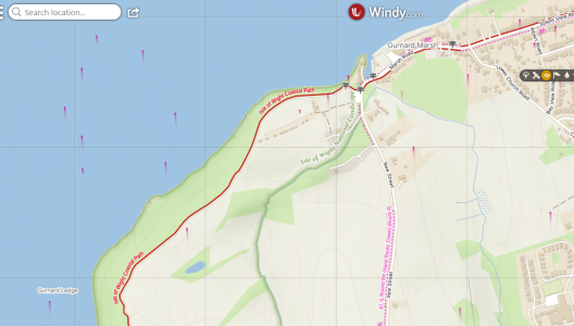
Zoom in on Windy and you also have an excellent road and street map.

.
 

GHA

Well-known member
Joined
26 Jun 2013
Messages
12,454
Location
Hopefully somewhere warm
Visit site
@GHA is that the premium version ? Is it worth the £20 approx a year ?
just tried it not logged in & it seemed to be the same, give it a go. I am premium, living on the hook I use it so much every day seemed just greedy not to give something back.

edit > seems they put a banner up if not premium. So in my case definitaly worth going premium just for that 😎

1706525393597.png
 
Last edited:

dunedin

Well-known member
Joined
3 Feb 2004
Messages
13,954
Location
Boat (over winters in) the Clyde
Visit site
Thought it was the opposite? No requirement for any paper with dual ecdis systems?
……
Correct, no paper charts needed for big commercial ships that can afford the space and cost requirements for two official ECDIS systems. Big and expensive.
But smaller commercial vessels don’t have the space or budget for twin ECDIS. And none of the “not for navigation” stuff like a Raymarine / Navionics combination (nor any equivalent Garmin, OpenCPN or anything else) counts for certification, Hence need paper charts for now for small commercial vessels.
Clearly it would be ideal for leisure craft charts / systems to be approved for navigation - but currently UKHO, amongst others, won’t allow their charts to be used in this way outside a formal ECDIS. So no solution exists for small craft.
 

GHA

Well-known member
Joined
26 Jun 2013
Messages
12,454
Location
Hopefully somewhere warm
Visit site
- but currently UKHO, amongst others, won’t allow their charts to be used in this way outside a formal ECDIS. So no solution exists for small craft.
Ocharts says this.
British Isles 2024 - o-charts shop
"We receive S-57 data directly from Hydrographical Offices, encrypt them in the oeSENC format and deliver chart sets for their individual use in OpenCPN.."

But anyway, it's irrelevant imho from a cruising perspective anyway. The little bays & anchorages are unlikely to have been surveyed for donkeys years. Don't trust anything! But almost trust satellite images & sort of trust any charts that match. So the cruisers I know pretty much all use electronic & the more enlightened & proactive use sasplanet mbtiles. Navionics must be the most popular. Only exception which Springs to mind is Nick on (& designer of) Wylo 11 who liked a sextant.
Not through any entrenched opinions but because, again from a cruising perspective, day to day in the real world it's just light years ahead of just paper. If you can even find any paper, used to be the big towns would have a copy shop with piles of already copied paper charts to use. Might not be so common now, haven't had to look for over a decade.
Either way with navionics / opencpn on a laptop/phone & tablet, which must be a very common setup, the doom & gloom "you're all going to die" just never happens. Ever. Walk around the bar at happy hour most cruisers will have the worlds charts on their phone with backups on the boat.
Just the way it is these days out and about the planet away from the Solent. 😊
 
Top