Looking for tide graph app for Android phone.

ProDave

Well-known member
Joined
5 Sep 2010
Messages
15,577
Location
Alness / Black Isle Northern Scottish Highlands.
Visit site
I think Absolute Tides is available (it’s on Google play if that means it’s an Android version - I’m Apple so not sure about Android). If so can recommend it.
That looked promising until I read

"
Displays officially licenced UKHO tidal data on an annual basis without ever needing to go online.

The tidal data is contained in our annual data plugins and must be purchased using in-app purchases. Therefore this app should not be considered a free app.

Once you have purchased the data, this app will allow you to view UKHO standard port tides up to a year in advance."

So just like EasyTide you have to pay to see more than 7 days ages. Do you know how much that is?

That's why I was hoping to find something like WXtide32 that calculates the data from first principles rather than buying it from UKHO
 

dunedin

Well-known member
Joined
3 Feb 2004
Messages
14,062
Location
Boat (over winters in) the Clyde
Visit site
That looked promising until I read

"
Displays officially licenced UKHO tidal data on an annual basis without ever needing to go online.

The tidal data is contained in our annual data plugins and must be purchased using in-app purchases. Therefore this app should not be considered a free app.

Once you have purchased the data, this app will allow you to view UKHO standard port tides up to a year in advance."

So just like EasyTide you have to pay to see more than 7 days ages. Do you know how much that is?

That's why I was hoping to find something like WXtide32 that calculates the data from first principles rather than buying it from UKHO
Absolute Tides does the job, is as accurate as any - as it uses UKHO data, and holds the data on the phone so doesn’t need internet access.

Are you too mean to pay circa £3.99 per year for the data?
 

Sandy

Well-known member
Joined
31 Aug 2011
Messages
21,898
Location
On the Celtic Fringe
duckduckgo.com
Once you have purchased the data, this app will allow you to view UKHO standard port tides up to a year in advance."
I bought the 2023 version about a month ago. £1.99 for 12 months, and yes I can see a full 12 months ahead. Every Primary and, as far as I can tell secondary port in Reeds.

In contrast the tide tables for Devonport, my local port, is £1.50.
 

FWB

N/A
Joined
29 Feb 2004
Messages
4,662
Location
Kernow
Visit site
If that’s a comment about feet then everything on the boat is in feet, depth, electronic charts. Only interested in depth when anchoring. Vertical distances in metres mean nothing to me. Aviation uses feet, a pity that Maritime isn’t in feet. The Americans use feet though.
 

Stemar

Well-known member
Joined
12 Sep 2001
Messages
23,903
Location
Home - Southampton, Boat - Gosport
Visit site
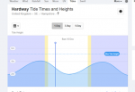
Graphs look pretty, but I have to question their accuracy for areas with unusual tides.

This one looks pretty for my club

1671356149157.png
but, in reality, after high water the tide drops very slowly for an hour or two, then someone pulls the plug and the bath empties. I'd love an app that does the local calculations for each hour to draw a graph, but I've yet to find one, so I've given up on graphs, as they seem to give a false sense of accuracy.
 

Sandy

Well-known member
Joined
31 Aug 2011
Messages
21,898
Location
On the Celtic Fringe
duckduckgo.com
If that’s a comment about feet then everything on the boat is in feet, depth, electronic charts. Only interested in depth when anchoring. Vertical distances in metres mean nothing to me. Aviation uses feet, a pity that Maritime isn’t in feet. The Americans use feet though.
Actually 'officially' the Americans use the metric system, but rather oddly they convert it back to that complicated imperial system. 3/32th and all that and as for fahrenheit! Perhaps they should use kelvin.

I reached the grand old age of 60 this year, was educated in metric and used it all my working life.

What size nuts and bolts do you use?
 

FWB

N/A
Joined
29 Feb 2004
Messages
4,662
Location
Kernow
Visit site
I can cope with metric but not for vertical distances. I’m 74 and was educated with SI units. A long retired Airline Captain. When landing the Radio Altimeter heights are called out in feet 100, 50, 30 …. If in metres would have been a few hard landings ?
Anyway I bet when asked how tall you are I bet you give it in feet and inches ?
 

FWB

N/A
Joined
29 Feb 2004
Messages
4,662
Location
Kernow
Visit site
Haha funnily enough I prefer my weight in kg too!
In Aviation we use metres for runway length and visibility. Kgs for a/c weight and fuel.
I just prefer my charts, tides and sounder in feet.
Back to the narrative…. Tides Planner is the best app!
 

dunedin

Well-known member
Joined
3 Feb 2004
Messages
14,062
Location
Boat (over winters in) the Clyde
Visit site
If that’s a comment about feet then everything on the boat is in feet, depth, electronic charts. Only interested in depth when anchoring. Vertical distances in metres mean nothing to me. Aviation uses feet, a pity that Maritime isn’t in feet. The Americans use feet though.
If you want to live in the 1950s, surely you should be using fathoms not feet - to match your black and white paper charts, complete with lovely drawings of coastal headlands and hills.
May be an issue keeping them up to date though - and certainly need a paper almanac, not a smartphone app :)
 

FWB

N/A
Joined
29 Feb 2004
Messages
4,662
Location
Kernow
Visit site
If you want to live in the 1950s, surely you should be using fathoms not feet - to match your black and white paper charts, complete with lovely drawings of coastal headlands and hills.
May be an issue keeping them up to date though - and certainly need a paper almanac, not a smartphone app :)
My point missed methinks.
 
Top