Garmin AIS integration a little help, what are my options??

Joined
30 May 2013
Messages
444
Visit site
Hi,

I really want to upgrade to AIS as we go further and longer passages as it really does help with night sailing

I’ve been using marine traffics thus far / digital yacht AIS on the iPad but it kills the battery and I have a spare back up plotter down below which I could replace / add AIS to

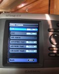
So I have a Garmin gpsmap 451 and routing around the menu there is AIS info on there but of course there is nothing plugged into the vhf? Aerial socket.

Now it does live next to the vhf radio so it could be straight forward, am I right in thinking if I buy a splitter will the AIS work or will I need some other equipment?

If my current plotter is just not up to it I’m open to the idea of getting a splitter and buying a new plotter with AIS built in ideally using the same power plug?

I’m a little lost with what’s the most cost effective route so would appreciate the advice of you fellow sailors here

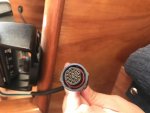
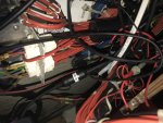
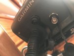
I’ve added a couple of pics to show the connections I have along with plotter (hopefully attachments work) the second pic shows the vhf aerial pic
 

Attachments

  • A4C03189-0091-4C4A-9420-601D99FCEFB8.jpg
    A4C03189-0091-4C4A-9420-601D99FCEFB8.jpg
    477.9 KB · Views: 14
  • DA8854B8-ABE7-4E83-930F-5CAFFA85D00A.jpg
    DA8854B8-ABE7-4E83-930F-5CAFFA85D00A.jpg
    477.6 KB · Views: 16
  • 18DDD978-05A1-4697-9D57-1DF815FDDFC0.jpg
    18DDD978-05A1-4697-9D57-1DF815FDDFC0.jpg
    214.2 KB · Views: 14

pvb

Well-known member
Joined
16 May 2001
Messages
45,604
Location
UK East Coast
Visit site
The aerial socket you refer to is for an external GPS antenna, nothing to do with AIS.

To display AIS data on your plotter you'll need an AIS receiver, which you can wire to one of the NMEA inputs of the plotter. One of the cheaper AIS receivers is the Quark A026 for £95 (https://jgtech.com/Communications/Communications-AIS/qk-026-ais.html), but you'll need to connect a VHF antenna to it, maybe using a splitter (which is going to cost another £100 or so). It might be easier and better value to sell your existing VHF radio on eBay and buy a new Standard Horizon GX2200E for £300 - this has an internal splitter and AIS receiver, and will just output AIS data on NMEA to your Garmin plotter. It also has an integral GPS receiver, so it provides redundancy in the event that your plotter stops working.
 

PaulRainbow

Well-known member
Joined
16 May 2016
Messages
15,920
Location
Suffolk
Visit site
The aerial socket you refer to is for an external GPS antenna, nothing to do with AIS.

To display AIS data on your plotter you'll need an AIS receiver, which you can wire to one of the NMEA inputs of the plotter. One of the cheaper AIS receivers is the Quark A026 for £95 (https://jgtech.com/Communications/Communications-AIS/qk-026-ais.html), but you'll need to connect a VHF antenna to it, maybe using a splitter (which is going to cost another £100 or so). It might be easier and better value to sell your existing VHF radio on eBay and buy a new Standard Horizon GX2200E for £300 - this has an internal splitter and AIS receiver, and will just output AIS data on NMEA to your Garmin plotter. It also has an integral GPS receiver, so it provides redundancy in the event that your plotter stops working.

+1 to all of this, including/especially the VHF suggestion :encouragement:
 
Joined
30 May 2013
Messages
444
Visit site
The aerial socket you refer to is for an external GPS antenna, nothing to do with AIS.

To display AIS data on your plotter you'll need an AIS receiver, which you can wire to one of the NMEA inputs of the plotter. One of the cheaper AIS receivers is the Quark A026 for £95 (https://jgtech.com/Communications/Communications-AIS/qk-026-ais.html), but you'll need to connect a VHF antenna to it, maybe using a splitter (which is going to cost another £100 or so). It might be easier and better value to sell your existing VHF radio on eBay and buy a new Standard Horizon GX2200E for £300 - this has an internal splitter and AIS receiver, and will just output AIS data on NMEA to your Garmin plotter. It also has an integral GPS receiver, so it provides redundancy in the event that your plotter stops working.

Apologies you might have to teach me to suck eggs here, nmea is a 5 pin plug on the back of the Garmin plotter? Or am I completely off the mark?

But sounds like a solution the current vhf is a ray marine ray 54e just in case there is some feature I’m missing

The only thing which would be a nice to have is to transmit as well as receive or is this another level of complexity?

Picture of back of plotter
 

Attachments

  • 0F7C60A3-D768-49CD-97DF-8FE23798ED93.jpg
    0F7C60A3-D768-49CD-97DF-8FE23798ED93.jpg
    483.3 KB · Views: 12
Last edited:

ShinyShoe

Well-known member
Joined
16 Nov 2013
Messages
1,782
Visit site
The other option is no splitter but a separate antenna. Cost similar. Gives spare that can be used in emergency for VHF.

If planning for emergency, likely not masthead. So less range. But the big fast guys will usually be higher up so more visible, the other yacht at 2 miles is fine...

You thinking receive only or thinking of tx too?

Cheapest AIS is about £60 unless you want to go down the open plotter on a pi with a dongle route.
 
Joined
30 May 2013
Messages
444
Visit site
The other option is no splitter but a separate antenna. Cost similar. Gives spare that can be used in emergency for VHF.

If planning for emergency, likely not masthead. So less range. But the big fast guys will usually be higher up so more visible, the other yacht at 2 miles is fine...

You thinking receive only or thinking of tx too?

Cheapest AIS is about £60 unless you want to go down the open plotter on a pi with a dongle route.

I’d prefer to transmit too if possible / reasonable cost
 

ShinyShoe

Well-known member
Joined
16 Nov 2013
Messages
1,782
Visit site
I’d prefer to transmit too if possible / reasonable cost
Ooo. Transmit and reasonable cost may not be hugely compatible!

You are either looking at £300 ISH for a transceiver. Slightly less if using the non-type approved (illegal) Chinese set or slightly over for a type approved black box. Still need antenna. If you want a splitter instead... It has to handle transmission on the AIS side too.

If you want to replace with an all in one solution... ICOM were working on something but I'm not sure it's available yet and price tag will presumably be £800
 

vas

Well-known member
Joined
21 Jun 2011
Messages
7,933
Location
Volos-Athens
Visit site
Apologies you might have to teach me to suck eggs here, nmea is a 5 pin plug on the back of the Garmin plotter? Or am I completely off the mark?

But sounds like a solution the current vhf is a ray marine ray 54e just in case there is some feature I’m missing

The only thing which would be a nice to have is to transmit as well as receive or is this another level of complexity?

Picture of back of plotter

looks like your plotter has a NMEA2000 socket that's what the 5pin one is (although the photo is not v.clear there)
In theory, and assuming the plotter WILL support the presentation of AIS targets on it's screen-YOU MUST INVESTIGATE THAT BEFORE PROCEEDING, you could buy any NMEA2000 compatible AIS transceiver (like the Garmin AIS800 or also an 600 available iirc) and buying a basic kit you create a NMEA2000 network (a power supply yellow cable, two terminators, two tees and 2 drop cables for the devices) and be ready to transmit. Need an extra VHF antenna or splitter though as mentioned above. Check on a layout for NMEA2000 networks.
Alternatively you can go NMEA0183 and fiddle with tiny cables and chocolate blocks or whatnot...

TBH, plotter is a bit on the small side for all that, wont be particularly easy to follow things on such a small screen (imho of course)

cheers

V.
 

pvb

Well-known member
Joined
16 May 2001
Messages
45,604
Location
UK East Coast
Visit site
Apologies you might have to teach me to suck eggs here, nmea is a 5 pin plug on the back of the Garmin plotter? Or am I completely off the mark?

The 5-pin is for NMEA2000. The Quark and Standard Horizon options I suggested use NMEA0183 - this is connected to the power/data cable of your plotter. If you look at the Garmin website, you can download the installation manual for your plotter, which details the connections, wire colours, etc. It really isn't necessary to create an NMEA2000 network as vas suggested, connections via NMEA0183 work fine and cheaper receivers don't have NMEA2000 connectivity.

The only thing which would be a nice to have is to transmit as well as receive or is this another level of complexity?

It is another level of complexity, but just requires more money to be thrown at it. A good choice for value would be an em-trak B100 for around £380, this will output AIS to your plotter on NMEA0183 as well as transmit your AIS data. But you'll also need a dedicated antenna or a splitter (£100 or so).
 
Last edited:
Joined
30 May 2013
Messages
444
Visit site
Thanks everyone for all your help I think I may look at getting the transponder unit and separate aerial sourced, not too worried about the small display on the Garmin, It Looks like you can set the alarm distance etc so for my needs it will be fine, I can always replace for a larger screen at a later date I would assume
 

PaulRainbow

Well-known member
Joined
16 May 2016
Messages
15,920
Location
Suffolk
Visit site
Thanks everyone for all your help I think I may look at getting the transponder unit and separate aerial sourced, not too worried about the small display on the Garmin, It Looks like you can set the alarm distance etc so for my needs it will be fine, I can always replace for a larger screen at a later date I would assume

If you opt for a separate VHF antenna the em-trak B100 PVB mentioned is a very good choice, it will output on NMEA 0183 and/or NMEA 2000. If you decide to go for a splitter, the em-trak sailor package is very good value, it comes with the B100 and a splitter.
 
Joined
30 May 2013
Messages
444
Visit site
If you opt for a separate VHF antenna the em-trak B100 PVB mentioned is a very good choice, it will output on NMEA 0183 and/or NMEA 2000. If you decide to go for a splitter, the em-trak sailor package is very good value, it comes with the B100 and a splitter.
Hi Paul,

thanks for your advice on this i think the sailor package is going to be the one i am going for after researching some more!

i do have one more question on this and im getting a little confused, looking at the manual for the B100 there is the connections to the chart plotter that's what I'm getting a little confused with.

so this is what im looking at in the manual, but am i right in what im reading in the manual that the connections to the chart plotter are only required is its not on the NMEA system already?

g2QMOai.png


so what im trying to say is can it not be connected as so in this mock up;

H18bhei.png


My Garmin isnt currently connected to the NMEA 2000 network and gets its GPS from the original GPS antenna on the boat, however there is also another GPS antenna on the NMEA 2000 network so that brings me onto a third option where if the b100 is connected to the NMEA network then surely it don't need a separate GPS antenna??

any help appreciated!
 

Jamie Dundee

Well-known member
Joined
24 Jul 2019
Messages
1,544
Visit site
The Simrad RS40B vhf has internal gps and vhf transponder, requires two separate antennae or a splitter. I have one, nice radio which will network via NMEA 2000.

Does cost around a grand though....
 

MikeCC

Well-known member
Joined
11 Apr 2005
Messages
1,234
Location
Exmouth, Devon
www.allGadgets.co.uk
Yes, you can do it like second diagram. You just need the NMEA2000 bits to connect to the bus. You could do it via NMEA0183 with a direct connection instead.

Rules on AIS transponders are that they need a dedicated GPS receiver.

What does the GPS antenna already on the NMEA2000 do?
 

PaulRainbow

Well-known member
Joined
16 May 2016
Messages
15,920
Location
Suffolk
Visit site
Hi Paul,

thanks for your advice on this i think the sailor package is going to be the one i am going for after researching some more!

i do have one more question on this and im getting a little confused, looking at the manual for the B100 there is the connections to the chart plotter that's what I'm getting a little confused with.

so this is what im looking at in the manual, but am i right in what im reading in the manual that the connections to the chart plotter are only required is its not on the NMEA system already?

g2QMOai.png


so what im trying to say is can it not be connected as so in this mock up;

H18bhei.png


My Garmin isnt currently connected to the NMEA 2000 network and gets its GPS from the original GPS antenna on the boat, however there is also another GPS antenna on the NMEA 2000 network so that brings me onto a third option where if the b100 is connected to the NMEA network then surely it don't need a separate GPS antenna??

any help appreciated!

Mike has pretty much covered this. I'd just add, i'd only have one GPS connected to the plotter, may as well be the N2K one as you're putting the plotter on the network for AIS. The bare wire connections on the AIS are for NMEA0183, so you don't need to use them.
 

vas

Well-known member
Joined
21 Jun 2011
Messages
7,933
Location
Volos-Athens
Visit site
My Garmin isnt currently connected to the NMEA 2000 network and gets its GPS from the original GPS antenna on the boat, however there is also another GPS antenna on the NMEA 2000 network so that brings me onto a third option where if the b100 is connected to the NMEA network then surely it don't need a separate GPS antenna??

any help appreciated!
you've probably misstyped the GPS antenna bit. If you don't have a N2K network, you cannot have any GPS antenna on the boat! Unless that's the antenna connected with a coaxial cable onto the plotter.
As mentioned above, the AIS needs it's own GPS antenna, and unless I'm mistaken WONT be broadcasting GPS data to the bus, so cannot really use it as a backup antenna fe.

I insist that all that is way too much (money and feature wise) for a 4in plotter!
 

Elemental

Well-known member
Joined
30 May 2007
Messages
1,198
Location
Weymouth
Visit site
I insist that all that is way too much (money and feature wise) for a 4in plotter!
Why? I have a Garmin 556 plotter (similar size screen I think). I can see the relative position of other AIS transmitters around me, I can see 'dangerous' targets highlighted in red, I can summon up a textual list of nearby targets with data including CPA and time to CPA and (if I had a transceiver) I'd be transmitting the relevant stuff for others to see me. What features can I not use on my little screen?
 

vas

Well-known member
Joined
21 Jun 2011
Messages
7,933
Location
Volos-Athens
Visit site
Why? I have a Garmin 556 plotter (similar size screen I think). I can see the relative position of other AIS transmitters around me, I can see 'dangerous' targets highlighted in red, I can summon up a textual list of nearby targets with data including CPA and time to CPA and (if I had a transceiver) I'd be transmitting the relevant stuff for others to see me. What features can I not use on my little screen?
yours is 5in OP is 4in - one inch out of 5 is some difference!
As I grow older the larger the better :D
 

Keith-i

Well-known member
Joined
4 Jul 2012
Messages
1,408
Location
Jersey
Visit site
For future simplicity I would go down the NMEA2000 route. Your new AIS unit will need its own GPS antenna as already mentioned. You can dispense with the co-ax GPS antenna on the plotter if you connect your exisitng NMEA2000 network to the plotter which, by the sounds of it, already has a GPS aerial on the network. Then all you need to do is connect the AIS box to a vhf aerial and the N2k network.
 
Joined
30 May 2013
Messages
444
Visit site
Yes, you can do it like second diagram. You just need the NMEA2000 bits to connect to the bus. You could do it via NMEA0183 with a direct connection instead.

Rules on AIS transponders are that they need a dedicated GPS receiver.

What does the GPS antenna already on the NMEA2000 do?

Well i think that answers me then - thanks! - there is a 2nd plotter up on deck which uses the NMEA GPS

thanks paul, I think your right with the two GPS signals i will disconnect the one connected to the garmin, its like the previous owner had two completely separate navigation systems on the boat (one on deck , one below), and linking them together will help in the future should i want to upgrade plotters i would imagine.

thanks everyone!
 
Top