Does your GPS get confused?

GHA

Well-known member
Joined
26 Jun 2013
Messages
12,253
Location
Hopefully somewhere warm
Visit site
Mine did yesterday, internal reciever on a Sony Xperia tablet running Opencpn

vV7MuMNh.jpg
 

{151760}

...
Joined
1 Nov 2014
Messages
1,048
Visit site
Mine doesn't, but I do. :)
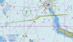
Using a tablet's internal GPS aerial is bound to be less efficient than a separate aerial, I would have thought, especially when used down below. It doesn't take much to interrupt the GPS signal.
 

GHA

Well-known member
Joined
26 Jun 2013
Messages
12,253
Location
Hopefully somewhere warm
Visit site
Pretty impressive knowing how weak the signal that it is trying to receive. What is the scale of the chart?
Each horizontal line is 1 minute lat so 1Nm. I can't remember anything similar using the boat gps 128 receiver as a data source so suspect it is the Xperia struggling. It was under the sprayhood on a steel boat.
 

Hydrozoan

Well-known member
Joined
11 Apr 2013
Messages
10,035
Visit site
I have posted before about being down below and noticing on the PC plotter (fed by a GPS ‘puck’) that our course had suddenly shifted by 90 degrees, such that we were heading out of the channel. Poking my head up I enquired of Mrs H on the tiller, only to be met with a frosty reception. She was, but the plotter was adamant that she was not. We were passing a large dockside radar tower at the time, and I have always wondered if that might conceivably have disrupted the GPS signal. What do the experts think?
 

Buck Turgidson

Well-known member
Joined
10 Apr 2012
Messages
3,190
Location
Zürich
Visit site
Well we are making approaches down to 200ft decision based on GPS lateral and vertical guidance so I wouldn't worry too much about Antacticpilots obsession with solar storms. SoL service is not affected according to the european space agency who run the EGNOS service.
 

elton

Well-known member
Joined
19 Oct 2005
Messages
17,482
Location
Durham, England
www.boatit.co.uk
The software/firmware is up the creek. It should filter the coordinates taking account of speed and reported accuracy of the positional data, and shouldn't make a plot like you're travelling at the speed of sound off track. The GPS tells the computer the accuracy of every coordinate it reports in terms of +/-%, and knowing the average speed it can interpolate, or correct. Take it back to the shop.
 

lw395

Well-known member
Joined
16 May 2007
Messages
41,951
Visit site
The software/firmware is up the creek. It should filter the coordinates taking account of speed and reported accuracy of the positional data, and shouldn't make a plot like you're travelling at the speed of sound off track. The GPS tells the computer the accuracy of every coordinate it reports in terms of +/-%, and knowing the average speed it can interpolate, or correct. Take it back to the shop.

I think you may be asking a lot of the tablet.
It's a general purpose consumer toy, with GPS added as a 'feature'.
Maybe there's a reason why a single purpose plotter costs more and doesn't even have a camera built in?
 

GHA

Well-known member
Joined
26 Jun 2013
Messages
12,253
Location
Hopefully somewhere warm
Visit site
What's weird is that some people navigate with dysfunctional junk like this!

Can you say for certain it was the GPS chip at fault and not the geomagnetic storm taking place at the same time?
Anyway, gps is an aid to navigation and in this instance the anomalies had zero effect on a safe passage. If you're completely reliant on GPS for navigation then sooner or later it's going come unstuck.
 

elton

Well-known member
Joined
19 Oct 2005
Messages
17,482
Location
Durham, England
www.boatit.co.uk
Can you say for certain it was the GPS chip at fault and not the geomagnetic storm taking place at the same time?
Anyway, gps is an aid to navigation and in this instance the anomalies had zero effect on a safe passage. If you're completely reliant on GPS for navigation then sooner or later it's going come unstuck.

I don't see how a geomagnetic storm could produce erroneous GPS data. If the data doesn't look complete and correct, it's rejected by the GPS engine, resulting in no coordinate data at that time. They have little things like checksums built into the data to accommodate such an occurance.
 

geoid96

Active member
Joined
19 Nov 2007
Messages
1,138
Location
51°50.100’N 001°46.020’E
Visit site
My guess is that the spikes are caused by a combination of poor satellite geometry and signal multipath. If there are plenty of satellites visible to the receiver, measured travel times of signals that have arrived by an indirect route can usually be rejected. However if there are only four visible (minimum for a 3D position) there is no measurement redundancy. If one signal path to the antenna is via a reflection off the mast, it is then difficult for the receiver to identify the bad range and an erroneous position may well be output.
 

runningman

Member
Joined
18 Jan 2015
Messages
106
Visit site
I once experienced loss of GPS signal on my phone/OpenCPN but at the same time the chartplotter was saying no GPS signal. If it was only one of the above then I would be investigating why. This underlines why it's important to have more than one GPS device. We have 4 independent systems in total. The only common denominator is the man-made lumps of metal in the sky. That's when one falls back to traditional methods of navigation & pilotage. My guess is there is a decreasing percentage of people on the water who are capable of doing this.
 

bedouin

Well-known member
Joined
16 May 2001
Messages
32,342
Visit site
It really is rather strange - there are several potential reasons why a GPS could give a wrong position but from the plot it appears that the errors were pretty much always either due West or due North. Random noise introduced into the GPS signal by poor reception or interference would be unlikely to produce that pattern of errors

I suspect it has to be some artifact of the GPS program on the tablet to produce that pattern.
 

AntarcticPilot

Well-known member
Joined
4 May 2007
Messages
10,096
Location
Cambridge, UK
www.cooperandyau.co.uk
I don't see how a geomagnetic storm could produce erroneous GPS data. If the data doesn't look complete and correct, it's rejected by the GPS engine, resulting in no coordinate data at that time. They have little things like checksums built into the data to accommodate such an occurance.

By causing varying delays in the ionosphere, which means that the time-of-flight of the signals is messed up. Used to be a routine problem in the polar regions, where Ionospheric effects happen much more frequently than in temperate zones. The content of the signal isn't messed up, so all the checksums are OK, but the time-of-flight measurement is messed up. If there are plenty of satellites in the solution, then the software should spot the problem and dump bad measurements, but older kit may not spot the problem because it's only tracking a few satellites.

A little later:
I've just remembered that I once saw a very nice presentation from people who were using the inverse of this to determine the Total Electron Content of the Ionosphere FROM GPS data!
 
Last edited:

lw395

Well-known member
Joined
16 May 2007
Messages
41,951
Visit site
It really is rather strange - there are several potential reasons why a GPS could give a wrong position but from the plot it appears that the errors were pretty much always either due West or due North. Random noise introduced into the GPS signal by poor reception or interference would be unlikely to produce that pattern of errors

I suspect it has to be some artifact of the GPS program on the tablet to produce that pattern.
I tend to agree.
It looks like the postion data coming from the GPS chips to the nav program is not being handled correctly.
And the nav program is not doing anything about it.
Which means the nav program either has no qualms about your boat moving by 1 mile sideways in 1 second (or whatever the GPS update rate is), or the corrupted data is fooling that filtering.

It doesn't look like the likely effects of a spoofing or jamming attack, unless it's carefully targetted at the OP's boat.....
 
Joined
18 May 2008
Messages
110
Location
Near. Conwy, North Wales
Visit site
My Garmin GPS 60 has made mistakes in the past. I was once sailing at about 4knts a few miles off the Great Orme in North Wales, when my Gps was showing my track at 2300Knts over the Balearic's.
A few moments later it showed me doing 140knts a hundred miles off the west coast of Ireland.!!

Meanwhile my Garmin 292 was showing my correct speed and position. :confused:

GPS60.jpg


I still have no idea why it did that. It's been reliable ever since.
 
Top