oldharry
Well-Known Member
Dear MMO,
As a registered Stakeholder, representing people who use the Studland anchorage we welcome the convenience of being provided free moorings at Studland even though we do not expect them to make any significant difference to eelgrass health.
No recent measurement has been taken of eelgrass health apart from our own very limited investigation, and the Seastar Survey of 2012, so there is no data benchmark from which to start. Without this data, there can be no evidence of the effectiveness or otherwise of this expensive operation.
We fully expect to be told by the Seahorse Trust, how much ‘difference’ it has made!
Before any further moorings are laid, local people who actually use the Bay need to be consulted. These first ones are very badly placed, placing users at significant risk.
The issues are well summed up a by someone who visited the Bay recently:
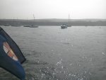
“Was anchored in Studland the other day. The new buoys are in deep water (4m) by my standards and quite a distance out even from the existing buoys. They are neat and compact and well spaced out but in the zone where boats speed up so creating wash. Whilst the wind was a westerly the sea was quite choppy compared with a lot closer in. Also if you want to go ashore you need an outboard on the dinghy, where my preferred anchor spots are a short row ashore. Was interesting that quite a few of them weren't used as boats preferred to be closer in. Also a few of the Bankes buoys not in use, presumably due to the dodgy chains. Will be interesting to see how it all pans out this year and whether they will survive the winter.”
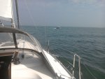
Further out where the new moorings have been laid there is a significant funnelling effect of offshore winds which have caught many visitors unawares, sadly with fatalities in the past.
The skipper of Musketeer was drowned when his inflatable dinghy was flipped by the wind in May 2012. It was anchored near where the new moorings now are. There have been other similar accidents since some involving the Rescue Services, thankfully none fatal.
Can I urge you not to approve any more moorings so far offshore until these safety issues are addressed, preferably by involving local people who will actually use them?
The buoys are marked 10 tons. Is that 10 tons TM, displacement or rating? They are 3 very different figures
A correspondent pointed out that his boat has a displacement of 14 Tons. However it is rated at 10 Tons on his Registration Documents, and a racing rating as a ‘One tonner’. Most owners know the registered Tonnage shown on Registration documents. By no means all will know the displacement. My own boat is registered as being 3.8 tons. Actual displacement is just over 2!
It does nothing for relations between users and conservation bodies when costly projects are undertaken without user consultation, and we urge you not to approve any more installations in Studland until these issues have been addressed through local boating organisations.
Much better AMS solutions are know to exist: Dr Richard Unsworth of Swansea University and founder of British Seagrass Survey has worked with the Sailing Club in Dale, Pembs, with a result acceptable to all, at a fraction of the cost of the Studland installation, and protecting both eelgrass, and boaters!
Kind Regards
Jon Reed
Founder Boat Owners Response Group
As a registered Stakeholder, representing people who use the Studland anchorage we welcome the convenience of being provided free moorings at Studland even though we do not expect them to make any significant difference to eelgrass health.
No recent measurement has been taken of eelgrass health apart from our own very limited investigation, and the Seastar Survey of 2012, so there is no data benchmark from which to start. Without this data, there can be no evidence of the effectiveness or otherwise of this expensive operation.
We fully expect to be told by the Seahorse Trust, how much ‘difference’ it has made!
Before any further moorings are laid, local people who actually use the Bay need to be consulted. These first ones are very badly placed, placing users at significant risk.
The issues are well summed up a by someone who visited the Bay recently:
“Was anchored in Studland the other day. The new buoys are in deep water (4m) by my standards and quite a distance out even from the existing buoys. They are neat and compact and well spaced out but in the zone where boats speed up so creating wash. Whilst the wind was a westerly the sea was quite choppy compared with a lot closer in. Also if you want to go ashore you need an outboard on the dinghy, where my preferred anchor spots are a short row ashore. Was interesting that quite a few of them weren't used as boats preferred to be closer in. Also a few of the Bankes buoys not in use, presumably due to the dodgy chains. Will be interesting to see how it all pans out this year and whether they will survive the winter.”
Further out where the new moorings have been laid there is a significant funnelling effect of offshore winds which have caught many visitors unawares, sadly with fatalities in the past.
The skipper of Musketeer was drowned when his inflatable dinghy was flipped by the wind in May 2012. It was anchored near where the new moorings now are. There have been other similar accidents since some involving the Rescue Services, thankfully none fatal.
Can I urge you not to approve any more moorings so far offshore until these safety issues are addressed, preferably by involving local people who will actually use them?
The buoys are marked 10 tons. Is that 10 tons TM, displacement or rating? They are 3 very different figures
A correspondent pointed out that his boat has a displacement of 14 Tons. However it is rated at 10 Tons on his Registration Documents, and a racing rating as a ‘One tonner’. Most owners know the registered Tonnage shown on Registration documents. By no means all will know the displacement. My own boat is registered as being 3.8 tons. Actual displacement is just over 2!
It does nothing for relations between users and conservation bodies when costly projects are undertaken without user consultation, and we urge you not to approve any more installations in Studland until these issues have been addressed through local boating organisations.
Much better AMS solutions are know to exist: Dr Richard Unsworth of Swansea University and founder of British Seagrass Survey has worked with the Sailing Club in Dale, Pembs, with a result acceptable to all, at a fraction of the cost of the Studland installation, and protecting both eelgrass, and boaters!
Kind Regards
Jon Reed
Founder Boat Owners Response Group