Crossing the Thames Estuary

Chris_d

Well-known member
Joined
15 Jun 2001
Messages
4,730
Location
Oxfordshire
Visit site
See, I knew I would get sound advice. Working on the assumption that baked beans are cheaper than diesel that should do the trick nicely 😁
A wrong assumption I fear, a 415g can of Heinz premium beans is £1.40 and the actual wind content is not clear, 415g of red diesel would be about 70p.

A more reliable source of wind would be to keep asking random questions on this forum.
 

Sea Hustler

Active member
Joined
18 Jan 2023
Messages
100
Visit site
A wrong assumption I fear, a 415g can of Heinz premium beans is £1.40 and the actual wind content is not clear, 415g of red diesel would be about 70p.

A more reliable source of wind would be to keep asking random questions on this forum.
Point 1. Shoot, I didn't realise this sailing lark was quite so complicated, My boat is 54 years old with a BMC Captain 1500 engine of similar vintage, I have heard that it can run on Dolphin shite and seaweed.
Point 2. Does that mean I could get away with Lidl Baked Beans as they retail at about 30p a tin or do you recommend I stick to the more premium barns for a cleaner burn..
 

Sea Hustler

Active member
Joined
18 Jan 2023
Messages
100
Visit site
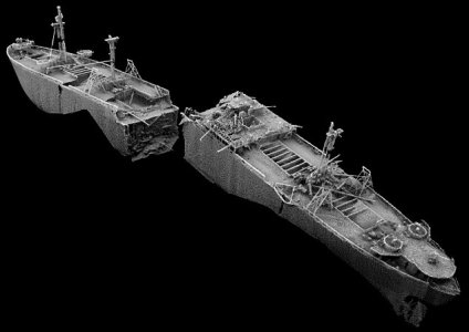
View attachment 173974
Try not to run into this .................at least not not before lunchtime anyway.
I noticed that lying about when I sailed passed that way back in 1944. nearly hit the damn thing, pretty careless of someone to leave an unmarked wreck there for so long, Was considering throwing a line around one of the masts and towing it out into deeper water just to make it safe.
 
Last edited:

prestomg27

Active member
Joined
24 May 2023
Messages
165
Visit site
My boat Presto is also based in Essex Marina and I have sailed to Ramsgate quite a lot from the Crouch., including a couple of times last year.

The easiest route is probably the SW Sunk, through fisherman's gat dropping straight down past North Foreland. It logs about 37 NM from the Inner Crouch to just of the marked channel to Ramsgate, so probably 40nm.
I used roger's book, crossing the Thames estaury to help with the passage planing and that manages to get tide assistance pretty much all the way other than the drop down to the SW Sunk. I haven't got my books with me so working from memory here I think the best time to leave essex marina is an hour or so past HW and aim to get to the SW Sunk around lowish water so you get the SW flood pulling you down.

Going through Havengore is a viable option but you can't go straight across or you will be walking. You could drop down to the kent side and then hug the kent coast through the gore channel. However, the bridge only operates in daylight hours and when the range is not being used, which generally means weekends. The tides don't work as well either.

A couple of observations for you, that I think are helpful:

1) Do not rely on charts for the SW Sunk. It has moved North East to the extent that there is a thread on here describing the grounding of a couple of yachts following what they thought was the correct route based on old data. Download Roger's survey updates from his 'crossing the thames estuary website'. If you do that you should probably do the decent thing and buy the book. I understand that Navionics has been updated with the latest survey (2022?)
2) I'm guessing from your description that yours is a colvic watson or Fisher type motor sailer with the 2 foot 6 draft. It is not a huge advantage on the east coast. You are either generally in a channel or walking. I would also think 5 knots is optimistic unless you motor the whole trip. They don't really sail to windward and are pretty slow with the wind. I would passage plan at 4 knots.
3) Don't go in a blow. It can get a really nasty sharp chop out there as the water goes from deepish to shallow in a few feet and the tidal streams go in different directions through the swatchways. Bear in mind the SW Sunk is not buoyed and you have to go through a chanel, out of sight of land, that is maybe 200Mish wide with a steep vertical side on the West side to crash into if you get it wrong. Alll at low water. Benign conditions a must.


Hope this helps. All that said, it is a really easy voyage to do with a bit of prep and a light westerly.
 

PeterWright

Well-known member
Joined
23 Aug 2006
Messages
1,141
Location
Burnham-on-Crouch, UK
Visit site
Hi,

Great that you have chosen Daydream's advice and leave the Crouch by the conventional route. I've not done the sums, but it seems to me that the Haven gore bridge is disfunction Al for about 30% of the days in a year, rather like all other equipment procured under a MoD contract.

Sticking to the main channels can be interpreted two ways, the first is to stick to shipping channels, which I would say is unnecessary, and the second is to use the shallower channels and swatch ways, I all of which are well surveyed and documented by Roger Gaspar, eminent author of the much recommended book. I do have a copy but must admit to rarely using it, but I do use both his associated website and his excellent weekly summary of E Coast notices to mariners published on the E Coast Forum of ybw. Com.

Using those to check current conditions, I would head from Essex marina, which is across the river from my house, down the river and on reaching the sea make straight for the Barrow no. 2 swatch way (chartlet on Roger's website) then make up the Black Deep for Foulger's gat to cross Long Sand through the London Array wind farm. This gat is buoyed, one at each end and one near the S end where you are expected to make a totally unnecessary dog's leg, I tend to head straight on to clear water, ignoring the last buoy. Once clear of the windmills, you can set course for N. Foreland from where Ramsgate is close, if you got your tides right.
As to tides, much of this passage is cross tide, but the first bit down the Crouch to the Barrow no. 2 swatchway needs the ebb, while the last bit from N. Foreland to Ramsgit needs the flood. The leg up Black Deep benefits from a flood tide, but to satisfy that and an ebb tide down to the Barrow no. 2 swatch way means crossing this swatch at low water. Drawing 6 foot, I prefer to arrive at the swatch way after the first hour of the flood has gone. Drawing 2'6",you needn't worry about this, if you cross at the right point, using Barrow no. 2 PHB to check your position and any tidal set.

Peter.
 
Last edited:

DoubleEnder

Well-known member
Joined
27 Apr 2002
Messages
1,421
Location
N Hemisphere
Visit site
Hi,

Great that you have chosen Daydream's advice and leave the Crouch by the conventional route. I've not done the sums, but it seems to me that the Haven gore bridge is disfunction Al for about 30% of the days in a year, rather like all other equipment procured under a MoD contract.

Sticking to the main channels can be interpreted two ways, the first is to stick to shipping channels, which I would say is unnecessary, and the second is to use the shallower channels and swatch ways, I all of which are well surveyed and documented by Roger Gaspar, eminent author of the much recommended book. I do have a copy but must admit to rarely using it, but I do use both his associated website and his excellent weekly summary of E Coast notices to mariners published on the E Coast Forum of ybw. Com.

Using those to check current conditions, I would head from Essex marina, which is across the river from my house, down the river and on reaching the sea make straight for the Barrow no. 2 swatch way (chartlet on Roger's website) then make up the Black Deep for Foulger's gat to cross Long Sand through the London Array wind farm. This gat is buoyed, one at each end and one near the S end where you are expected to make a totally unnecessary dog's leg, I tend to head straight on to clear water, ignoring the last buoy. Once clear of the windmills, you can set course for N. Foreland from where Ramsgate is close, if you got your tides right.
As to tides, much of this passage is cross tide, but the first bit down the Crouch to the Barrow no. 2 swatchway needs the ebb, while the last bit from N. Foreland to Ramsgit needs the flood. The leg up Black Deep benefits from a flood tide, but to satisfy that and an ebb tide down to the Barrow no. 2 swatch way means crossing this swatch at low water. Drawing 6 foot, I prefer to arrive at the swatch way after the first hour of the flood has gone. Drawing 2'6",you needn't worry about this, if you cross at the right point, using Barrow no. 2 PHB to check your position and any tidal set.

Peter.
Thats all excellent advice and a very do able plan. The only thing I'd add is that the little stretch between N Foreland and Ramsgate can, for some reason, be surprisingly bouncy when wind is against tide. I don't think it is anything particularly to worry about, just be aware. I came round once heading north, and got a bit chucked about. At one point the tiller went totally light and I thought "aargh the rudder has dropped off". In fact the boat was picked up on a wave and the whole back end was in the air....
 

Sea Hustler

Active member
Joined
18 Jan 2023
Messages
100
Visit site
Hi,

Great that you have chosen Daydream's advice and leave the Crouch by the conventional route. I've not done the sums, but it seems to me that the Haven gore bridge is disfunction Al for about 30% of the days in a year, rather like all other equipment procured under a MoD contract.

Sticking to the main channels can be interpreted two ways, the first is to stick to shipping channels, which I would say is unnecessary, and the second is to use the shallower channels and swatch ways, I all of which are well surveyed and documented by Roger Gaspar, eminent author of the much recommended book. I do have a copy but must admit to rarely using it, but I do use both his associated website and his excellent weekly summary of E Coast notices to mariners published on the E Coast Forum of ybw. Com.

Using those to check current conditions, I would head from Essex marina, which is across the river from my house, down the river and on reaching the sea make straight for the Barrow no. 2 swatch way (chartlet on Roger's website) then make up the Black Deep for Foulger's gat to cross Long Sand through the London Array wind farm. This gat is buoyed, one at each end and one near the S end where you are expected to make a totally unnecessary dog's leg, I tend to head straight on to clear water, ignoring the last buoy. Once clear of the windmills, you can set course for N. Foreland from where Ramsgate is close, if you got your tides right.
As to tides, much of this passage is cross tide, but the first bit down the Crouch to the Barrow no. 2 swatchway needs the ebb, while the last bit from N. Foreland to Ramsgit needs the flood. The leg up Black Deep benefits from a flood tide, but to satisfy that and an ebb tide down to the Barrow no. 2 swatch way means crossing this swatch at low water. Drawing 6 foot, I prefer to arrive at the swatch way after the first hour of the flood has gone. Drawing 2'6",you needn't worry about this, if you cross at the right point, using Barrow no. 2 PHB to check your position and any tidal set.

Peter.
Thanks for that comprehensive advice. Could now have a slight spanner in the works because we went up the the boat for a couple of days and did a bit of sailing (well tried to anyway) We set off from Burnham Yacht harbour with 4 hours of the Ebb still running and got out to the end of the Whitaker channel in about 2 hrs where we unfurled the rags to see how she handles under sail on the open water. There was very littel breeze, about 4 knt according to the reports and we frankly made about 1.5 knots backwards most of the time. Conclusion was that if we don't get a reasonable bit of wind (Im not going out in anything above a force 5 not with such shallow draft myself) so we agreed we will probably motor sail the entire route. My crew has now decided he does not want to sail at night so now Im trying to plan the passage using daylight only. Doing some calculations, I reckon we achieved about 5- 5.5 knots with the engine on and because I have time constraints with work and other stuff, I need to do this in as short a time as possible. If I anchored near the mouth of the Crouch overnight then caught the start of the Ebb tide at first light (if poss) how far do you think would be a reasonable distance I could achieve towards Chichester on day one, I need to stretch the distances out now so I would like to get beyond Ramsgate if I can. I will get Reeds out and check tides but as someone that obviously knows those waters, you advise would be appreciated..
 

Daydream believer

Well-known member
Joined
6 Oct 2012
Messages
20,949
Location
Southminster, essex
Visit site
I agree with Peter Wright #30 ( makes a change) about crossing by Barrow No2. Get there 1.5-2 hrs before LW then cross the Sunk on a heading of 137 deg..Now punch the tide for a while. I do not use the foulgers Gat Route. I like to use the tower by Fishermas Gat as a guide & spin round that with the echo sounder showing 4M under the keel. This cuts the corner. But be aware that this adds 4+ miles to the trip. Getting across the sunk & down to F Gat by the turn of the tide gives you 6 hours of tide, most of which you need between N & s Foreland. It is 12 miles from F Gat to N foreland so you need to hurry up.
.
However, you use the tide & do not have the problem of navigating the southern crossing which is unmarked. The S swatchway is every bit as dangerous for a bilge keeler as a single keeled boat. I know as I saw my friends boat tipped over to 160 degrees. Bilge keelers do not always sit upright when aground.
There is often a ship coming down the Black Deep so keep well out of the way & although you will be crossing diagonally, do it quickly if you see something in the distance. They come up fast.Listen to the VHF for Sunk VHF if they call you to advise of shipping.
.
Once into the Gat go diagonally to the other end where there is a finger of sand. Watch the echo sounder so you know when you cross it to cut the corner, then head S for N Foreland. Keep an eye out for shipping & have the VHF on dual watch ( VHF 14 I think) This is one place where I turn my chart plotter on as it has the AIS function.
If you gun it to N Foreland you should be able to make South Foreland as the tide turns against you. Then you may find yourself plugging a big chop at the end for a while until you see Dover harbour. Follow advice in Reeds & the Channel Pilot ( which you have) for entry.
.
I normally sail the whole way from Bradwell in 9 hours inc berthing. However, if you spend the night anchored in the bay at the mouth of the Crouch on the S side then you should do it in 10
.
There is a scanky pub with good beer on the right at the start of the shopping area & a good chip shop if you go to the centre then bear right & 200 yds up the street. Of course the yacht club on the sea front is welcoming & there is a chip shop just before you get there. Not sure how they feel about scruffs though.
 
Last edited:

Sea Hustler

Active member
Joined
18 Jan 2023
Messages
100
Visit site
Again, many thanks for the great advice, I will print it off and take it with me. now I guess its all down to the weather playing nice.
 

Sea Hustler

Active member
Joined
18 Jan 2023
Messages
100
Visit site
Well we did it, the original plan was to depart Burnham on Crouch on 25th May (personal stuff was delaying departure) but with that suddenly cleared we looked for a suitable weather window and Hey Presto, everything was set fair for an extended spell around 17th so we took the plunge. As there was expected to be no real wind to speak of 3 - 4 knots at best, the plan was to motor the entire way if necessary so we departed Burnham at 6. 30 am on 17th heading for Dover.

Armed with printed copies of all the good advice others on this forum had given me, plus Savvy Navvy and an old Garmin chartplotter we set off into the wild blue yonder. I cant ever recall the sea state being so friendly, almost glasslike, sun shining (oh you should see how burnt my face is, NOTE TO SELF, buy a hat) and just a hint of a breeze though not even enough to ripple the water surface. Although I had been given much good advice, and many had suggested heading out to Barrow No 2 before hanging a right, we ultimately whipped around the Inner Whitaker, nipped between Middle and SW Sunk and through Fisherman's Gat hardly seeing another vessel let alone worrying about being run down by some hoon behind the wheel of a giant Supertanker, determined to squash us flat at all costs. Once clear of Fisherman's we made a beeline for N Foreland.

I had lived for years just behind the headland and could see the lighthouse from my bedroom window, had lain in bed on countless foggy nights listening to the horn blast out its warning, suggesting that Mariners change their course a few points or risk being caught on my Ring Doorbell camera (not really, we didn't have em in those days) There was something special about sailing past the N Foreland on the seaward side, passed Joss Bay - where I proposed to my Wife, and Broadstairs where I had spent many years of my life dreaming about one day owning one of the thousands of boats I would watch traverse the horizon, and here I was actually doing it. The Tidal Gods were smiling on our little adventure and we arrive at Dover some eight and a half hours after departure. After berthing up it was off to do the necessaries at the Marina Office before some chow and a celebratory bottle of a nice Merlot before hitting the sack for the night.

Next morning it was an early departure heading for Eastbourne, My boat had not seen a wave in anger for over 5 years as she had been used all that time as a floating apartment tied to a pontoon. So it was a nervous time constantly checking the oil pressure gauge and water temp, listening for the slightest change in engine note or unexplained vibration, but she just pressed on into the most interesting rolling swell which was just the perfect pitch to create a rhythmical washing machine effect adding real excitement to the art of making a brew. Drinking it was almost as intriguing just seeing if you could time it so the cup to the lip, the sip and the swallow could all be achieved in a controlled and chronological manner - nope... not really and much mopping up of spilt tea proved necessary all round.

The entrance to Sovereign Harbour hoved into view out of the blue after 9 1/2 hours - literally, had it not been for Savvy Navvy we would have motored right past it. Strange how different somewhere looks from the seaward side as opposed to how you imagined it would be, waited to lock up before entering and killing the engine safely tied up to our allotted berth. Ashore for some nosh and a shower and a quick trip to the 'offie' for a bottle of falling down water, before calling it a night ready for another early departure the next day.

Next day dawned another fine day, the weather belying the slightly queasy feeling in the pit of my stomach courtesy of something I must have eaten the night before, with a gentle haze over a calm sea and just a hint of a breeze to accompany the last leg ot the voyage. Having departed Eastbourne, I got my head down for a couple of hours in the hope of a more settled constitution after a little more shut eye. Three hours later I was fine and after a brew, was ready to take my turn at the helm bringing us safely into Chichester Harbour about 9 hours after clearing the lock at Sovereign Harbour. Having missed the tide (we were never going to make it anyway) we opted to overnight in Sparkes Marina before chasing the flood up to our new mooring the next morning.

Hmm, interesting approach to Sparkes methinks. Not sure who thought it would be a good idea to let kids swim in the " our own 1.5mt dredged channel" approaching the entrance but it did make for an exciting end to another successful day and we entered without liquidizing any small children with the fast spinning prop. I did actually crick my neck at one point constantly checking astern for the stream of blood and body parts churning out behind us as we made our way up the channel, we managed to avoid turning Johnny and his chums into Kid Puree and arrived at the Marina without incident. All berthed up we went ashore to complete the paperwork before deciding the 15 minute walk to the nearest watering hole was 15 minutes too far for that celebratory pint to end out adventure. We opted instead for a meal and 1 or 3 - maybe 4 pints in the onsite restaurant, nice food but expensive, before calling it a night.

Next morning after waking at a reasonable hour for the first time on the trip, we had a leisurely breakfast of scrambled eggs on toast before casting off and heading upstream for our new mooring, Once arrived we picked up our buoy and spent a few hours "confirming how tidy we had kept my wife's boat the entire trip" we rowed ashore absolutely knackered but content that we had done it without serious mishap.

Oh apart from discovering that we could not quite reach the shoreline and and that it was shoes and sock off and a paddle through about 4 inches of water and 6 inches of black stinky mud to get the dingy to dry land. Then a short taxi ride to the nearest station and the train home arriving utterly shattered at about 3.00 pm yesterday afternoon .

Thanks everyone that help with their sound advice, I did try and use the best of it where I could but I can safely say, I will never be tempted to write on this forum again "There are many threads on here"
Cheers Mike
 
Last edited:

Sea Hustler

Active member
Joined
18 Jan 2023
Messages
100
Visit site
Thanks for reporting back. It is really much easier once you have done it. Good luck with your sailing adventures. We look forward to more posts.
Thanks, I did spend the entire day watching the surface of the water for the merest hint that the mighty Kraken was about to rear itself out of the water and attack the good ship Sea Hustler, but fortunately it must have been on its holidays because we saw neither sight nor sound of the dreaded beast the whole four days of our trip.
 
Top