robertager1962
Well-Known Member
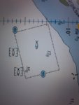
Hi all. I wonder if I could ask your advice. We are currently travelling to Cadiz and the charts denote areas which show a dashed line and a fish inside (see attached image).
I have scoured the admiralty key but it tells me that these are fishery limits and I am not sure about them. I steered clear of them on our last passage only to watch every Tom Dick and Harry gaily traversing them. My main concern was that I set up Navionics to perform an automatic route and it avoided them.
I have scoured the admiralty key but it tells me that these are fishery limits and I am not sure about them. I steered clear of them on our last passage only to watch every Tom Dick and Harry gaily traversing them. My main concern was that I set up Navionics to perform an automatic route and it avoided them.


")

