Bradwell Creek

Dee Bee

Active member
Joined
17 Jul 2018
Messages
117
Visit site
Can anyone tell me how far either side of HTthat I can get into Bradwell Marina with a draft of 1.3m?
 

Lucky Duck

Well-known member
Joined
9 Jun 2009
Messages
8,449
Visit site
If coming from, say, the Orwell then arrival and departure tend to be towards high water so the creek shouldn't be an issue.

You may well touch the bottom in the marina at low water although this hasn't led to any remarkable issues in my experience.
 

tillergirl

Well-known member
Joined
5 Nov 2002
Messages
8,607
Location
West Mersea
Visit site
Well.......

I was just thinking it wouldn't be too difficult to draw up a prediction table but then I thought just: Tides for Bradwell Waterside, East of England - BBC Weather

Play with the graph. For example today you would have got 2m height of tide 1hr 40 minutes after LW. It is going neap from now. Thursday is the 'neapest' and you would still have 2m 1 hr 50 minutes after LW. If you can get over the 'bar' you can get right in. The bottom in the marked channel is luvely and soft. There is a little better depth dans the middle BUT there used to be some moorings once; the mooring has gone but the sinkers? LG's point has got to be right. If you are coming in early, you might think going round the SHB is a little challenging (looming mud ahead). But it isn't.
 

John 32i

Active member
Joined
5 Jul 2011
Messages
836
Location
Levington
Visit site
We came in today at half tide with a 2m draft and no problem - currently 2.4 in the marina with another hour and a half until low water.
 

PeterWright

Well-known member
Joined
23 Aug 2006
Messages
1,189
Location
Burnham-on-Crouch, UK
Visit site
My current boat has a designed draft of 6 feet or 1,8288m, but with all the junk we carry, I prefer to think of it as 1,85 m and she fits comfortably in my concept of "half tide ports" of which Bradwell is one. This concept should suit any yacht with draft of 2m or less and saves a lot of fiddling around with tide tables and tidal curves. The basis of it is that, in the absence of a significant surge, the available depth at half tide doesn't vary much from springs to neaps. To qualify as a half tide port, there must be sufficient water to enter or leave with a 2m draft boat at half tide. Work out once if a port qualifies then, provided you draw 2m or less youknow until the local bottom moves that half tide is good enough. I do reassess entrances where the depth varies, like the Deben and the Ore, the first time in every year and the Deben still qualifies, as it has done every year since the 1950's when I first crossed that bar. For me, this year's first crossing was last week.

First time I ever entered Bradwell creek was 1972 and it has remained in my list of half tide ports ever since, as has Brightlingsea, just across the river, which I first entered in a yacht in 1974, although I did sail dinghies in and out of there in the sixties.

Thanks to Roger's work, half tide swatchways can be added to the list nowadays.

Peter.
 

Yorkshire Exile

Active member
Joined
17 Apr 2017
Messages
242
Visit site
Tillergirl's chart of the creek still holds good. The shallowest part is between the middle two red cans. There are currently only two withies in place. one of which is all but submerged at HW and the other is wonky! A boat's width either side of the red cans is the place to be.
http://www.crossingthethamesestuary.com/Bradwell 2019.jpg
I've been in and out of Bradwell a few times and not had problems, but sssuming Tillergirl's survey is accurate (and I'm sure it is!), then why isn't the marked channel to the East of the present one, thus avoiding the 0.3 M section of the spit?
 

tillergirl

Well-known member
Joined
5 Nov 2002
Messages
8,607
Location
West Mersea
Visit site
Defence submission:

1. The chartlet is based on a full survey 5 years ago supplemented with some annual checks through the marked 'channel' and the assistance of a copy of results of a professional survey. I have been thinking it might be worthwhile re-doing it. It happens I will be going over on Monday morning to re-fuel and so I'll have a chat with Arthur to ensure there are no works about. I could re-do this week coming: tide is perfect for the time and the weather looks good as well.
2. There has been some thinking that the shape of the Creek might be gradually changing because of the reduction of the Baffle Wall down river and the opening of the sea wall a little bit higher up so I had waited a few years to re-do it. Actually if you look at the chartlets in the 1920/30's the best water was centre of the Creek but certainly in the 70/80's best water was in the current marked channel.
3. There used to be a line of moorings pretty much just centre of the 'best water'. The moorings have almost gone but have the old sinkers been lifted? Personally I doubt but I don't know. The issue is if you did touch in the current marked channel you will find a nice soft bit mud and can wait. Indeed a few times I put some revs on and get through. But if we touched in the 'best water' could we clump an old sinker? And just for the sake of another 0.2m?
4. I think it is difficult for the Marina. They have to satisfy Trinity House and moving the long standing channel would need some justification (I don't really know the small print over such matters though) and could incur some more costs (more buoys). Could they dredge that lump? Enviromental rules exist and permissions would be needed etc, etc.

I think it has to be erred on the side of safety so whilst it isn't the 'best water' I personally think it is the 'best choice'.

A late PS: Looking back at my chartlet 5 years ago best water was just outside the line of red buoys and just outside the red buoys would be well clear of any old sinkers. Best it is time for a re-survey.
 
Last edited:

MoodySabre

Well-known member
Joined
24 Oct 2006
Messages
17,416
Location
Bradwell and Leigh-on-Sea
Visit site
That would interesting Roger (TG). There have been occasions when that extra 0.2 was essential.

When leaving and heading up river or returning I don’t bother to go round the cardinal post. Seems like the same depth.

Perhaps you could ask Arthur to reinstate the depth gauge which is presumably buried in the mud after it fell off.
 

tillergirl

Well-known member
Joined
5 Nov 2002
Messages
8,607
Location
West Mersea
Visit site
Just a joke. Seriously I am thinking of redoing. It has been a while.

I was going to write out the 1933 edition of 'Rivers and Creeks of the Thames Estuary' but it contains two pages of guidance so I funked out of typing all that. It has an excellent pen and ink chartlet, has three transits into the creek (!) and a nice pen and ink showing the second transit 'Green Man signboard in one with 2nd tree on right'. See if you can pick that up.
 

Black Diamond

Active member
Joined
5 Aug 2009
Messages
259
Location
West Mersea
Visit site
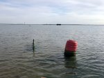
I did a quick poke around with an oar this morning, and it appears that the second port hand buoy is sitting bang in the middle of a horse. If I can ask Roger to do the clever stuff on predicted depth, the picture was taken at bang on 8.00am this morning, and the depth was less than a foot at the buoy. However, there is at least two feet extra depth 20 yards towards the Peewit Island bank, and also 20 yards towards the Bradwell shore. The broken withy is a useful reference.

Bradwell No.2 buoy.jpg
 

MoodySabre

Well-known member
Joined
24 Oct 2006
Messages
17,416
Location
Bradwell and Leigh-on-Sea
Visit site
Is that pic taken with a long lens? The buoy and the withy are not that close. Well they weren’t yesterday. Tillergirl was in Bradwell yesterday - passed him in the channel close to that point.
 
Top