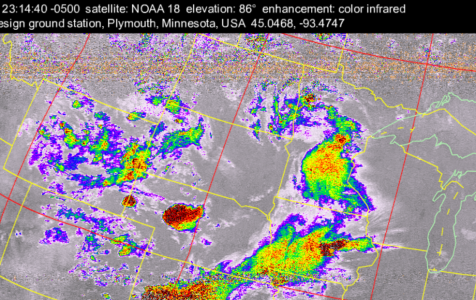
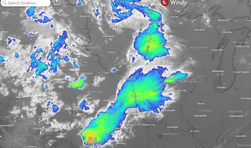
Anyone receiving weather images straight from the satellites?

GHA

Well-known member
Joined
26 Jun 2013
Messages
12,412
Location
Hopefully somewhere warm
Visit site
This came up in another thread > Your longest rope on the boat

Has been on the "really must get round to that soon" todo list.

Did it before years ago just using the ham radio & backstay antenna which is probably as bad a choice as there could be onboard but a just about readable image came out!

So anyone else doing this? (Apart from Frank)

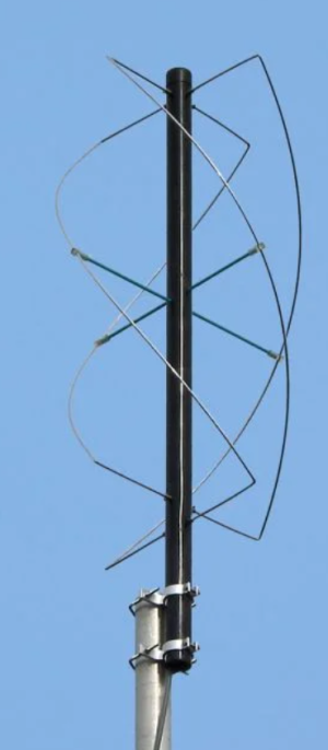
Would be interesting hearing about antenna design, Franks (turnstile?) antenna seems smaller than the ones google came up with would look a bit less odd on the backstay to a quadrifiler-
1720344814076.png
 

GHA

Well-known member
Joined
26 Jun 2013
Messages
12,412
Location
Hopefully somewhere warm
Visit site
What images are actually broadcast from satellites?
this is one from Frank that he received on his boat, in the other thread.

04140837-jpeg.179558
 
  • Like
Reactions: vas

GHA

Well-known member
Joined
26 Jun 2013
Messages
12,412
Location
Hopefully somewhere warm
Visit site
not bad, no idea, but once you figure out, wouldn't mind trying next winter :)
Nothing out of the backstay & ham radio earlier as noaa19 & 18 went over.... better make a weird antenna then 😁
A lot of people use rtl dongles, then get the sound into a raspberry pi it will record a file, hopefully automated so images every day 😎
 

Roberto

Well-known member
Joined
20 Jul 2001
Messages
5,241
Location
Lorient/Paris
sybrancaleone.blogspot.com
So anyone else doing this? (Apart from Frank)

I had bookmarked this combination aerial/receiver for a possible purchase, the antenna is quite compact and would fit among all the others I have on the stern arch. SDR dongles, amplifiers, qfh antenna etc require too much programming and DIY for me
WRAASE electronic | Weather Satellite Receiver Systems

Just seen the picture of Frank Holden boat, it seems to be the same antenna.
 
Last edited:
  • Like
Reactions: GHA

GHA

Well-known member
Joined
26 Jun 2013
Messages
12,412
Location
Hopefully somewhere warm
Visit site
I had bookmarked this combination aerial/receiver for a possible purchase, the antenna is quite compact and would fit among all the others I have on the stern arch. SDR dongles, amplifiers, qfh antenna etc require too much programming and DIY for me
WRAASE electronic | Weather Satellite Receiver Systems

Just seen the picture of Frank Holden boat, it seems to be the same antenna.
Thanks for the link. Antenna looks ideal, apart from the price.... can't really justify that unfortunately.
 

AntarcticPilot

Well-known member
Joined
4 May 2007
Messages
10,318
Location
Cambridge, UK
www.cooperandyau.co.uk
Of course, all satellite images are potentially receivable directly from satellites - that is how they are downlinked to ground stations. So no doubt an amateur radio enthusiast could receive the signals and decode them.

HOWEVER!!! What is down linked is NOT necessarily the image you want. What is downlinked is in what are called engineering units - in other words, more or less raw output from the sensors. They need to be converted at the ground processing station into physical units, and the calibration curves and algorithms are not always straightforward linear relationships. The data downloaded doesn't have any location data - that is obtained from a model of the satellite orbit. There may also be arbitrary decisions as to how to interpret the downlinked data - certainly the case for altimetric data (is the measured point the first arrival or the midpoint of the slope of the arrivals? By convention it's the latter, but you need to know that!). SAR data would be almost impossible for an amateur to use - what comes down is not an image but data that are used by complex algorithms to create an image, requiring a powerful machine to do it in a timely manner (it was supercomputer or purpose built processor in the 1980s and 90s)

I was involved in this stuff in the 1980s as a small part of the team that designed the UK processing system for ERS-1.
 

GHA

Well-known member
Joined
26 Jun 2013
Messages
12,412
Location
Hopefully somewhere warm
Visit site
Of course, all satellite images are potentially receivable directly from satellites - that is how they are downlinked to ground stations. So no doubt an amateur radio enthusiast could receive the signals and decode them.

HOWEVER!!! What is down linked is NOT necessarily the image you want. What is downlinked is in what are called engineering units - in other words, more or less raw output from the sensors. They need to be converted at the ground processing station into physical units, and the calibration curves and algorithms are not always straightforward linear relationships. The data downloaded doesn't have any location data - that is obtained from a model of the satellite orbit. There may also be arbitrary decisions as to how to interpret the downlinked data - certainly the case for altimetric data (is the measured point the first arrival or the midpoint of the slope of the arrivals? By convention it's the latter, but you need to know that!). SAR data would be almost impossible for an amateur to use - what comes down is not an image but data that are used by complex algorithms to create an image, requiring a powerful machine to do it in a timely manner (it was supercomputer or purpose built processor in the 1980s and 90s)

I was involved in this stuff in the 1980s as a small part of the team that designed the UK processing system for ERS-1.
wxtoimg does all the decoding, then allows for a load of different enhancements like infra red. Plus overlays country boundaries in for you which can be seen in the image above with infra red giving a good idea of rain. . Easy to see it lining up with the land in the image. End of the day it works very well, it creates very useful live satellite images of where you are for free. Almost for free, I just need an antenna, everything else exists already. 😎
 

AntarcticPilot

Well-known member
Joined
4 May 2007
Messages
10,318
Location
Cambridge, UK
www.cooperandyau.co.uk
wxtoimg does all the decoding, then allows for a load of different enhancements like infra red. Plus overlays country boundaries in for you which can be seen in the image above with infra red giving a good idea of rain. . Easy to see it lining up with the land in the image. End of the day it works very well, it creates very useful live satellite images of where you are for free. Almost for free, I just need an antenna, everything else exists already. 😎
I'd be interested to see how it does the conversion from engineering units to physical ones. It's not difficult in the case of weather satellite images; most of what I wrote is for more complex sensors (I was particularly involved with satellite altimeters, and worked with people who were dealing with SAR and Passive Microwave instruments). Also, I guess that precise calibration isn't that important for amateur use of weather satellite imagery, and in any case, weather satellites are designed to be relatively easy to access.
 

GHA

Well-known member
Joined
26 Jun 2013
Messages
12,412
Location
Hopefully somewhere warm
Visit site
I'd be interested to see how it does the conversion from engineering units to physical ones. It's not difficult in the case of weather satellite images; most of what I wrote is for more complex sensors (I was particularly involved with satellite altimeters, and worked with people who were dealing with SAR and Passive Microwave instruments). Also, I guess that precise calibration isn't that important for amateur use of weather satellite imagery, and in any case, weather satellites are designed to be relatively easy to access.
Sounds very interesting but not really much use on the boat, opencpn weatherfax can download sat images which when overlaid on top of a grib or weatherfax can be handy to see how far off a weather front is & as a check for the gribs. Should be pretty easy to do the same with images downloaded straight from space. Not much openplotter, opencpn & a raspberry Pi can't do 😎
 

KompetentKrew

Well-known member
Joined
27 May 2018
Messages
2,359
Visit site
https://www.reddit.com/r/amateursatellites

Start out by receiving FM radio on your desired device - that proves your hardware is playing nice together.

Then use a V-dipole for NOAA satellites - I think you should be able to get an acceptable quality of images using that if you're in an anchorage or offshore, but a QFH should be better.

The ARRL antenna book has a section on QFH antennas - copies of various editions at archive.org
 
  • Like
Reactions: GHA

GHA

Well-known member
Joined
26 Jun 2013
Messages
12,412
Location
Hopefully somewhere warm
Visit site
Pics of dipole and received image in this thread: https://www.reddit.com/1dwn33r
Thnx
Got the ham radio 2m/70Cm reconnected earlier & could just hear a signalk when noaa15 went over but not enough to get an image, though 15 is on it's last legs apparently so maybe that's part of it. The 2m antenna is tuned to 144Mhz & swr still low at 137Mhz so should get something, but mounted vertical which is pointing straight up & not side on! vee dipole might be worth a play in the yard but don't think it's really the way forward at sea, would be hard to keep it north/south, quadrifiler might be the best choice out there.
All good fun learning stuff though!! 😎
 

KompetentKrew

Well-known member
Joined
27 May 2018
Messages
2,359
Visit site
quadrifiler might be the best choice out there.
Oh, I think so.

I think it's the ARRL book that I bookmarked because I wanted to understand the dimensions of QFH antennas. Can they be longer and thinner and achieve comparable performance to one that is flatter and wider? I think most homemade QFH's are quite ugly, and I pondered how to build a satisfactory one - if you could build a QFH that's as narrow as a drainpipe then you could tape copper wire to the outside of a plastic drainpipe, cover it in white fablon and it would appear quite satisfactory. Not much wind drag either. I never concluded looking this up though.
 
Top