Always trust your charts???
- Thread starter john_morris_uk
- Start date
Daydream believer
Well-known member
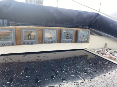
6.1 M? That is not shallow. That much water would frighten the life out of some east coast Thames estuary sailors. Anything that they cannot touch with a bamboo cane would be a no noMy point is that the echo sounder and your eyes while your mosey around don’t lie. Just do it cautiously in shallow waters.
Fr J Hackett
Well-known member
I like the way the reefs are shown with sharp teeth. 
To answer Daydream believer it also works the other way around, I moved from the blue and deep water of the SW to the brown and shallow waters of the east coast and in the 3 years I was there I never felt completely happy sailing with half a meter and less under my keel or finding my way across the Thames Estuary ( eternally grateful for the Wonderfull work crossing the Thames Estuary)
To answer Daydream believer it also works the other way around, I moved from the blue and deep water of the SW to the brown and shallow waters of the east coast and in the 3 years I was there I never felt completely happy sailing with half a meter and less under my keel or finding my way across the Thames Estuary ( eternally grateful for the Wonderfull work crossing the Thames Estuary)
penfold
Well-known member
Chart makers tend to be conservative, although that does seem extreme.
john_morris_uk
Well-known member
Chart makers can only work with the data they’re given. The Grenadines are notoriously poor in their surveying.Chart makers tend to be conservative, although that does seem extreme.
dunedin
Well-known member
Surely most people in these areas work also by Google Earth, due to the frequency of chart datum and location errors?
Mind you coming down the West side of Hoy last week it was noticeable that 2/3rds of the coastline on the latest UKHO chart stIll shows it simple as white and “unsurveyed” - and that is one of the high traffic areas and the lee shore for a regular ferry route.
Mind you coming down the West side of Hoy last week it was noticeable that 2/3rds of the coastline on the latest UKHO chart stIll shows it simple as white and “unsurveyed” - and that is one of the high traffic areas and the lee shore for a regular ferry route.
john_morris_uk
Well-known member
The vast majority of the worlds seas and oceans are very poorly surveyed. We are spoiled in home waters as most is surveyed accurately and updated reasonably frequently.Surely most people in these areas work also by Google Earth, due to the frequency of chart datum and location errors?
Mind you coming down the West side of Hoy last week it was noticeable that 2/3rds of the coastline on the latest UKHO chart stIll shows it simple as white and “unsurveyed” - and that is one of the high traffic areas and the lee shore for a regular ferry route.
However even in UK waters and in non commercially or military sensitive areas; who’s paying for the survey?
LadyInBed
Well-known member
Far too deep to anchor, think of all the chain I would have to deploy!6.1 M? That is not shallow.
RunAgroundHard
Well-known member
I participate in a Raymarine forum and a similar comment was made about Navionics, except the person had run aground because it was a lot shallower than than the electronic chart suggested. They may have been using autoroute as well, can't remember. All charts, as suggested by others, will contain errors, navigator due diligence and all that. Is the GPS position correct?
capnsensible
Well-known member
Navionics. Say no more.......
john_morris_uk
Well-known member
What’s correct? What datum?I participate in a Raymarine forum and a similar comment was made about Navionics, except the person had run aground because it was a lot shallower than than the electronic chart suggested. They may have been using autoroute as well, can't remember. All charts, as suggested by others, will contain errors, navigator due diligence and all that. Is the GPS position correct?
RunAgroundHard
Well-known member
Maybe you could have cross checked with a 3 point fix, or something like that.What’s correct? What datum?
mainsail1
Well-known member
Please explain........... I did think of going the Navionics route but stayed with C map for now.Navionics. Say no more.......
Roberto
Well-known member
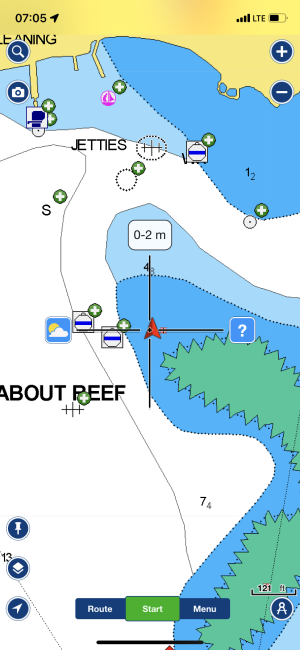
I looked quickly at the available charts (to hydrographic standards) for the areas, they seem to be drawn at scales between 1:20 000 and 1 : 50 000 (?); Anyway, whatever actual figures, 1/20 000 means 1mm = 20m, the hydrographic "half pencil width" would be 10m, the trace on the chart cannot be more detailed than that, or 25m if 1/50 000 scale.
On my PC screen the image above has a scale (bottom right) of 126ft/2.4cm, that is 15 real meters equal 1 *centimeter* on my screen. Of course to be adjusted to the size of the actual display. On my screen the boat position could be anywhere in a radius of 1-2cm (depending upon original scale) around the plotted cross.
Add to that, those charts are probably CATZOC B (at best), which means an horizontal position error of +-50m.
One of the fundamental failings of leisure electronic charting (mostly commercially driven), allowing "overzooming" without warning + not indicating the CATZOC margin of error: a "serious" electronic chart system would have told you "careful there is a margin of error of 50-75-100m as to your position related to this chart", but then they would not be able to sell charts of North Korea with 50cm spaced contours
john_morris_uk
Well-known member
You sum it up very nicely. Too many European sailors get used to the amazingly high standards of accuracy of most home waters charting. They then start to hit things when they go further afield.I looked quickly at the available charts (to hydrographic standards) for the areas, they seem to be drawn at scales between 1:20 000 and 1 : 50 000 (?); Anyway, whatever actual figures, 1/20 000 means 1mm = 20m, the hydrographic "half pencil width" would be 10m, the trace on the chart cannot be more detailed than that, or 25m if 1/50 000 scale.
On my PC screen the image above has a scale (bottom right) of 126ft/2.4cm, that is 15 real meters equal 1 *centimeter* on my screen. Of course to be adjusted to the size of the actual display. On my screen the boat position could be anywhere in a radius of 1-2cm (depending upon original scale) around the plotted cross.
Add to that, those charts are probably CATZOC B (at best), which means an horizontal position error of +-50m.
One of the fundamental failings of leisure electronic charting (mostly commercially driven), allowing "overzooming" without warning + not indicating the CATZOC margin of error: a "serious" electronic chart system would have told you "careful there is a margin of error of 50-75-100m as to your position related to this chart", but then they would not be able to sell charts of North Korea with 50cm spaced contours
I’m not immune. When we were exploring this anchorage we were going very very slowly looking for a free space whilst watching the echo sounder carefully. 5 metres became gentle crunch in a moment. The water is so clear you can’t judge depth with any great confidence by simply looking. The charting is up the creek bug a top tip is to use Google Earth as s cross reference.
Roberto
Well-known member
I think no one is, when one has the chance of zooming in in in, why not, the machine should tell "careful that's too much".I’m not immune.
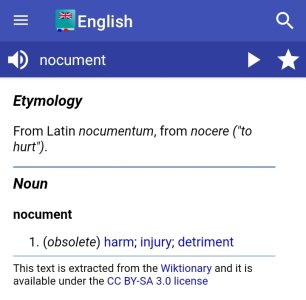
Electronic charting devices made this way are nocuments to navigation, not aids imho. (I rushed to check if the nocument word exists in English and it seems so, even if archaic obsolete etc etc).
D
Deleted member 478
Guest
I had to look the word up because I've never heard it.I think no one is, when one has the chance of zooming in in in, why not, the machine should tell "careful that's too much".
Electronic charting devices made this way are nocuments to navigation, not aids imho. (I rushed to check if the nocument word exists in English and it seems so, even if archaic obsolete etc etc).

Giblets
Well-known member
John, do you not have a lead line on board your trusty vessel? I'm a firm believer in the Mk 1 eyeball plus a bit of weighted string in unfamiliar close quarters situations.You sum it up very nicely. Too many European sailors get used to the amazingly high standards of accuracy of most home waters charting. They then start to hit things when they go further afield.
I’m not immune. When we were exploring this anchorage we were going very very slowly looking for a free space whilst watching the echo sounder carefully. 5 metres became gentle crunch in a moment. The water is so clear you can’t judge depth with any great confidence by simply looking. The charting is up the creek bug a top tip is to use Google Earth as s cross reference.
john_morris_uk
Well-known member
Yes, I have a lead line. I’m balancing mutiny from the crew vs asking her to use it.John, do you not have a lead line on board your trusty vessel? I'm a firm believer in the Mk 1 eyeball plus a bit of weighted string in unfamiliar close quarters situations.
capnsensible
Well-known member
Personally, I think it's awful and error prone.Please explain........... I did think of going the Navionics route but stayed with C map for now.
Members online
- Bouba
- kingsebi
- Knig
- westernman
- NormanS
- CardiffSailor
- bedouin
- PabloPicasso
- Laser310
- Tiger Lily
- JamesDavis
- Baddox
- jct1981
- William_H
- crewman
- Tranona
- Time Out
- Bodach na mara
- LoneHort
- Scubaboy79
- Sybarite
- Dellquay13
- Hurricane
- StoneBay
- Anchorite
- BootOftheBeast
- Wansworth
- DreadShips
- Hial
- Solwaycruiser
- Misterbreeze
- ANDY_W
- Avocet
- noelex
- DAKA
- jbmia
- Pye_End
- SC35
- Momac
Total: 717 (members: 47, guests: 670)


