simonjk
Well-known member
****
DO YOU NEED TO GET 'WEATHER WHYS'?
This 2-hour DVD comprises a series of short videos explainsing how the weather works and how you can improve your DIY forecasting techniques.
See free sample videos online at http://www.weatherweb.net/weatherwhys.htm
****
Hello again,
The weather does not look too bad for the weekend. A little doubt over conditions in the southeast on Saturday morning, but apart from that we may just get an early taste of spring.
Thanks to all of you who are using SWIS. Take a look for yourself at http://www.sailingweather.co.uk Forecasts are free and updated 3xper day. This service is developing all the time and I’ll be announcing some exciting enhancements soon.
If you want to learn more about the weather then the next Sailing Weather School (Part 1) is to be held in Southampton on Saturday 5th March. I have one more place left on the course and you can see more information and book your place online at http://www.weatherschool.co.uk This course is for all sailors, whatever your experience. You will learn much about the weather and how you can optimise your sailing by making better assessments of weather patterns.
Onto the weekend forecast, and if you know anyone who’d like to receive this email each week just tell them to send a request to join to
sailingweather-subscribe@weatherweb.net Also, feel free to forward this email to onto any sailing friends or groups.
Have a good weekend,
Simon
WEEKEND WEATHER FORECAST
Issued: 1600 Thursday 24th February 2011
SATURDAY
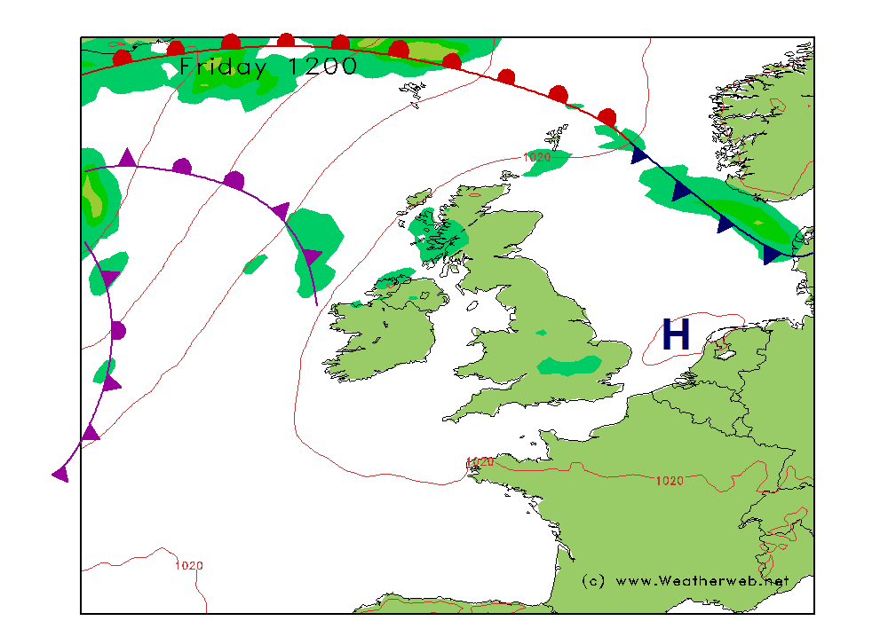
A cold front is going to be clearing southeast England through Saturday, although latest indications are that the clearance may be slower than shown on the chart below. There could be rain across the southeast quarter of England at first on Saturday, and this could be heavy at times. It will bring moderate or poor visibility and low cloud with it, although it should eventually clear away into the Continent. This is an area to watch though as I expect this forecast to change. The trough should also clear southeast, although I do have a suspicion that the rain may not clear parts of Kent until late afternoon.
Pressure is then likely to be rising slightly from the west and this is going to be bringing generally improved conditions to all parts of the country. There will be some decent spells of sunshine and for most it should be dry with good visibility. Only western coasts of Scotland and Ireland are likely to see some scattered showers, but for most the day is going to be fair.
Winds mainly W 6-10kt (F2-F3) in the south, tending to become more W-NW through the day. Generally W-WSW 15-20kt (F5) in western Scotland, SW 12-17kt (F4-F5) in the east.
SUNDAY
Sunday sees an area of high pressure becoming more established to the south of the country. A ridge extends from the high through the UK and Ireland, although the trough marked on the chart indicates that the air is unstable. This means that despite conditions being generally fair for most of the country, there will be a tendency for showers to form in the afternoon. Visibility will be good overall, but moderate in any showers.
It will be high ground and windward facing coasts which are likely to be able to trigger the showers and so the most favoured spots for these are Wales, the Midlands, southern England and western parts of Scotland.
Winds mainly NW 8-12kt (F3-F4) but to 15kt (F4-F5) on western coasts. The winds backing through the day to become more northerly by evening.

***ends***
DO YOU NEED TO GET 'WEATHER WHYS'?
This 2-hour DVD comprises a series of short videos explainsing how the weather works and how you can improve your DIY forecasting techniques.
See free sample videos online at http://www.weatherweb.net/weatherwhys.htm
****
Hello again,
The weather does not look too bad for the weekend. A little doubt over conditions in the southeast on Saturday morning, but apart from that we may just get an early taste of spring.
Thanks to all of you who are using SWIS. Take a look for yourself at http://www.sailingweather.co.uk Forecasts are free and updated 3xper day. This service is developing all the time and I’ll be announcing some exciting enhancements soon.
If you want to learn more about the weather then the next Sailing Weather School (Part 1) is to be held in Southampton on Saturday 5th March. I have one more place left on the course and you can see more information and book your place online at http://www.weatherschool.co.uk This course is for all sailors, whatever your experience. You will learn much about the weather and how you can optimise your sailing by making better assessments of weather patterns.
Onto the weekend forecast, and if you know anyone who’d like to receive this email each week just tell them to send a request to join to
sailingweather-subscribe@weatherweb.net Also, feel free to forward this email to onto any sailing friends or groups.
Have a good weekend,
Simon
WEEKEND WEATHER FORECAST
Issued: 1600 Thursday 24th February 2011
SATURDAY
A cold front is going to be clearing southeast England through Saturday, although latest indications are that the clearance may be slower than shown on the chart below. There could be rain across the southeast quarter of England at first on Saturday, and this could be heavy at times. It will bring moderate or poor visibility and low cloud with it, although it should eventually clear away into the Continent. This is an area to watch though as I expect this forecast to change. The trough should also clear southeast, although I do have a suspicion that the rain may not clear parts of Kent until late afternoon.
Pressure is then likely to be rising slightly from the west and this is going to be bringing generally improved conditions to all parts of the country. There will be some decent spells of sunshine and for most it should be dry with good visibility. Only western coasts of Scotland and Ireland are likely to see some scattered showers, but for most the day is going to be fair.
Winds mainly W 6-10kt (F2-F3) in the south, tending to become more W-NW through the day. Generally W-WSW 15-20kt (F5) in western Scotland, SW 12-17kt (F4-F5) in the east.
SUNDAY
Sunday sees an area of high pressure becoming more established to the south of the country. A ridge extends from the high through the UK and Ireland, although the trough marked on the chart indicates that the air is unstable. This means that despite conditions being generally fair for most of the country, there will be a tendency for showers to form in the afternoon. Visibility will be good overall, but moderate in any showers.
It will be high ground and windward facing coasts which are likely to be able to trigger the showers and so the most favoured spots for these are Wales, the Midlands, southern England and western parts of Scotland.
Winds mainly NW 8-12kt (F3-F4) but to 15kt (F4-F5) on western coasts. The winds backing through the day to become more northerly by evening.
***ends***