You are using an out of date browser. It may not display this or other websites correctly.
You should upgrade or use an alternative browser.
You should upgrade or use an alternative browser.
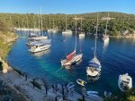
Time for a 'Where am I?' picture?
- Thread starter davidlhill
- Start date
Sticky Fingers
Well-known member
Looks like Croatia. Okuklije?
paulajayne
Active member
Stood approx 10 metres above sea level pointing a photo taking device at some boats.
Do I Win?
Do I Win?
Last edited:
Clancy Moped
Well-known member
Meganisi?
JumbleDuck
Well-known member
Peterhead?
crewman
Active member
If it was not so crowded it could be Scotland!
davidlhill
Well-known member
Croatia yes, Okuklije no.......Looks like Croatia. Okuklije?
davidlhill
Well-known member
Stood approx 10 metres above see level pointing a photo taking device at some boats.
Do I Win?
Completely accurate, yet strangely unhelpful ? ? ? ? ?
Sticky Fingers
Well-known member
Ooh, close-ish then. Hum. It looks familar.Croatia yes, Okuklije no.......
newtothis
Well-known member
Win? He's in Croatia and will soon be launching a GoFundMe page to pay for his mooring fees. I wouldn't expect too much.Do I Win?
RichardS
N/A
I instantly thought Okuklje as well but then thought that the jetty is not quite in the right place. Great minds and all that.Looks like Croatia. Okuklije?
Richard
Baggywrinkle
Well-known member
Maslinica, top end of Solta ... Sesula bay.
RichardS
N/A
How about Sesula? The raft of boats at the end doesn't quite fit but otherwise it's similar.
Richard
Richard
Sticky Fingers
Well-known member
Ah yes could be I've been there too so at least it ticks the 'possibly familar' box.How about Sesula? The raft of boats at the end doesn't quite fit but otherwise it's similar.
Richard
Baggywrinkle
Well-known member
It is Sesula... and if I'm not mistaken, taken with an iPhone 11 Pro, 1/1600 sec, f/1.8 and 4,25mm at ISO32 on 01.07.2021 at around 7:08pm 
Baggywrinkle
Well-known member
... guess who forgot to strip the metadata out of the photo. ?
RichardS
N/A
Does the metadata give the coordinates? If not, how does it help?... guess who forgot to strip the metadata out of the photo. ?
Richard
JumbleDuck
Well-known member
In this case:Does the metadata give the coordinates? If not, how does it help?
GPS Latitude Ref : North
GPS Longitude Ref : East
GPS Altitude Ref : Above Sea Level
GPS Speed Ref : km/h
GPS Speed : 0
GPS Img Direction Ref : Magnetic North
GPS Img Direction : 121.8147851
GPS Dest Bearing Ref : Magnetic North
GPS Dest Bearing : 121.8147851
GPS Horizontal Positioning Error: 165 m
GPS Altitude : 8.7 m Above Sea Level
GPS Latitude : 43 deg 23' 41.36" N
GPS Longitude : 16 deg 12' 43.19" E
GPS Position : 43 deg 23' 41.36" N, 16 deg 12' 43.19" E
and there we go

Baggywrinkle
Well-known member
RichardS
N/A
Ah .... so the question is whether you decided on Sesula at the same time as I did with or without the help from the metadata?It contains the geodata of where the picture was taken, which the photo editing software interprets and produces a little map .... in this case this one:
View attachment 120533
... much better explained by JumbleDuck ? ? ?
Richard
Other threads that may be of interest
Members online
- Crystal
- Milgrip
- KompetentKrew
- IanCC
- jasperthedog
- steppygas
- Joe T
- Plum
- alahol2
- black mercury
- springer
- kwb78
- Barton Seagoon
- Baggywrinkle
- RunAgroundHard
- BobnLesley
- Sticky Fingers
- Mister E
- mcanderson
- Boathook
- TobPhil
- artisan
- zoidberg
- Flyingspanner
- johnalison
- westhinder
- wingcommander
- kindredspirit
- newtothis
- Hoist
- scurr
- jwilson
- mikegunn
- Buck Turgidson
- Lucky Duck
- underdog
- veshengro
- Robertpat20
- MapisM
Total: 4,159 (members: 50, guests: 4,109)


