Severe storm hits Poros near Athens

ostra4

Member
Joined
11 Jul 2004
Messages
291
Location
west yorks/Greece ionian
Visit site
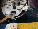
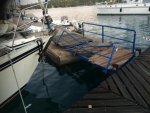
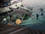
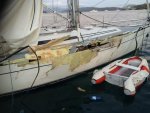
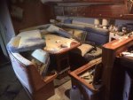
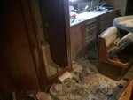
My friend was in Poros on Friday evening aboard their Bavaria 38 ,they went out to eat and returned early evening to the boat , very little wind around 1930 hrs .Shortly after the sky darkened and wind speed increased to 69 knots within a few minutes resulting in carnage on the quay , Iv attached some sad pictures .Insurance assors have been out , my pals boat also caught fire which he dealt with by using three dry powder extinguishers .No one was injured apart from scrapes and bruising . Once again totally urn forecast Greek weather strikes again .
 

Attachments

  • image.jpg
    image.jpg
    90.6 KB · Views: 3
  • image.jpg
    image.jpg
    91.4 KB · Views: 3
  • image.jpg
    image.jpg
    90.7 KB · Views: 3
  • image.jpg
    image.jpg
    93.5 KB · Views: 2
  • image.jpg
    image.jpg
    81.1 KB · Views: 2
  • image.jpg
    image.jpg
    76.9 KB · Views: 2
  • image.jpg
    image.jpg
    60.5 KB · Views: 2

ostra4

Member
Joined
11 Jul 2004
Messages
291
Location
west yorks/Greece ionian
Visit site
It sounds very similar to the storm that hit Vlihon, I was aboard our boat heading towards Vliho that day and my pals description is almost the same . The port police have been most helpful in the aftermath in Poros and it was they who confirmed the windspeed on Friday . We also know that Vliho suffered quite a severe storm last Friday evening as well , a friend aboard his 44 ft Bavaria was knocked flat twice with some damage but not as bad as Poros !
 

macd

Active member
Joined
25 Jan 2004
Messages
10,604
Location
Bricks & mortar: Italy. Boat: Aegean
Visit site
It is indeed profoundly unfortunate, and we also have friends who suffered damage elsewhere in the same storms. Sincere sympathy to all of them.

Unforecast? Maybe. However, perhaps "totally" is a bit strong.

I'm afraid I don't have a record of what the Greek GMDSS area forecast was at the time, although I'd be interested if anyone has a contemporary copy. I imagine it just gave a moderate Beaufort force and 'thunderstorms', possibly 'severe'. Such forecasts shouldn't be relied on to predict wind speeds in thunderstorms with any accuracy and don't even try to: they're never likely to predict F11, or whatever it was, except as a gradient wind.

Grib forecasts, as I recall, showed a large band of rain. Gribs, of course, never directly indicate thundery weather, but it's a prudent bet, particularly at this time of year, than rain and thunder go together. But CAPE values, strongly associated with thundery conditions, were also forecast to be elevated -- certainly high enough to suggest violent thunderstorms. Anyone who sails in Greece is aware, or should be, that thunderstorms are often associated with wild winds from unpredictable directions.

Real-time lightning maps (not forecasts) had earlier shown a very energetic band of lightning over NW Greece, clearly moving south and east. It was this band which caused widespread trouble, later stretching unroken from the Ionian to Evia and onwards. (A smaller hotspot also traversed Kalkidiki.) Anyone who'd seen this depiction of lightning moving their way would have been worried. I know I was. (Fortunately we were well tucked up in Limni and got just one brief blast of about 40knots.)

Much of this might not have been revealed by a quick look at a forecast, and to be constantly aware of it is a counsel of perfection that few of us achieve (especially when the sun's on your face and the breeze is balmy, as it was on the preceding afternoon). And the bottom line is that even that would not have given an inkling of 60+knot winds, because such events are too small, too localised and too ephemeral to be predicted in such detail. But there were signs that something unpleasant was on its way.
 
Last edited:

ostra4

Member
Joined
11 Jul 2004
Messages
291
Location
west yorks/Greece ionian
Visit site
Perhaps totally may have been too strong but certainly my friends have been sailing Greek and Turkish waters for many years and are aware that these events happen . I woukd suggest that many times wev had feelings that something was about to happen weather wise looking at cloud formations and se state only for nothing to materialise and conditions remained stable . The afternoon of the Vliho storm felt slightly odd but I wouldn't have expected conditions to escalate in the way they did , generally we look at a couple of forecasts and make decisions on that although often a predicted storm or very high winds don't materialise .Iv attached the Poisoden forecast around that time and although some weather around nothing seems to jump out that Coukd have indicated what was to come . Around forty boats were damaged along with our friends boat , their pushpit was crushed by a neighbouring catermerang hull crashing down on top due to wave height, there was a two mile fetch to where these boats were moored on the quay.
 

Attachments

  • image.jpg
    image.jpg
    95 KB · Views: 2

Mwinda

Member
Joined
24 Jan 2008
Messages
111
Visit site
Scary photos, must have been scary conditions - appreciate you posting. Glad to hear no injuries or worse. Interesting that from the photo the pontoon (apart from the dent where it was hit!) seems to have remained in place. Its fairly deep at Poros at the catwalk/pontoon (8-10m I recall) so its easy to see how you rapidly end up with totally inadequate scope if it bombs. The Poseidon screen shot is interesting, wind all coming from the South. It would be good to see the GRIB files /Hellenic Met text forecast - as macd notes above would probably have set alarm bells. Poseidon is good when its good, but can get it badly wrong (as any forecast).
 

macd

Active member
Joined
25 Jan 2004
Messages
10,604
Location
Bricks & mortar: Italy. Boat: Aegean
Visit site
Perhaps totally may have been too strong but certainly my friends have been sailing Greek and Turkish waters for many years and are aware that these events happen . I woukd suggest that many times wev had feelings that something was about to happen weather wise looking at cloud formations and se state only for nothing to materialise and conditions remained stable . The afternoon of the Vliho storm felt slightly odd but I wouldn't have expected conditions to escalate in the way they did , generally we look at a couple of forecasts and make decisions on that although often a predicted storm or very high winds don't materialise .Iv attached the Poisoden forecast around that time and although some weather around nothing seems to jump out that Coukd have indicated what was to come . Around forty boats were damaged along with our friends boat , their pushpit was crushed by a neighbouring catermerang hull crashing down on top due to wave height, there was a two mile fetch to where these boats were moored on the quay.

All true. And of course the problem with thunderstorms is that you can be tucked away beautifully protected from the forecast gradient wind, and then get blasted from a totally different direction, as seems to have happened in Poros and elsewhere. Boats at anchor seem to fare better: even if they drag, they usually won't smash into and grind against a quay. I have a liking when thunder's about for roomy anchorages with gently sloping bottoms (and good holding, obviously), so I can swing any old way.

As I stressed earlier, forecasts will not give any indication of thunder cell winds, and many (GMDSS stuff excepted) will give no direct indication whatever of even thundery activity. If we want that information, we must seek it by other means.

I wonder, just in passing, whether there's another dimension to our awareness of these things. As a species we seem to be more fearful of lightning than anything else about a thunderstorm, and for understandable reasons. But the element that caused all last weekend's damage (and that at Vliho) wasn't lightning, but sheer wind.

All we can really do is learn any lessons, sympathise with those hit hardest and mutter 'there but for the grace of god...'

The lightning site I mentioned is here: http://en.blitzortung.org/live_lightning_maps.php?map=14
As said, it's in real time, not a forecast...and bloody priceless. As I write, there's some nasty stuff west of Ithaca/Zante; slow-moving but heading, I think, SE. (The colours give the clue to this: white is newest strikes, red oldest.) Since we plan to be on a quite exposed mooring buoy tomorrow night, pending lift-out on Wednesday morning, I'll be watching it all with the keenest interest.

P.S. There's currently a low heading for the Peloponnese from the SW. It's CAPE values are huge. Due later today and through the night in SW Greece, tomorrow into Wednesday in the Aegean. Safe sailing, all.
 
Last edited:

duncan99210

Well-known member
Joined
29 Jul 2009
Messages
6,332
Location
Winter in Falmouth, summer on board Rampage.
djbyrne.wordpress.com
Getting the forecast right is difficult in Greek coastal (or indeed, most coastal) waters. macd is right about the influence of thunderstorms: I've learnt to look at the grib files and where there's reasonably heavy rain forecast I assume that there'll be thunderstorms associated with it. I then head for a safe anchorage to sit things out.

Even so, we were caught out this year when we were in Vonitsa. The forecast wind was light from the south. We got force 7-8 from the east and had to vacate the quay and go to anchor. We moved before the worst of the wind arrived but still felt safer at anchor than on the quay. The winds then proceed to blow for several hours, none of it forecast or associated with a thunderstorm.

I have a lot of sympathy with the folks whose boat were damaged or sunk and I'm pleased to hear that the PP were helpful,
 

RobbieW

Well-known member
Joined
24 Jun 2007
Messages
4,887
Location
On land for now
Visit site
....
The lightning site I mentioned is here: http://en.blitzortung.org/live_lightning_maps.php?map=14
As said, it's in real time, not a forecast...and bloody priceless. As I write, there's some nasty stuff west of Ithaca/Zante; slow-moving but heading, I think, SE. (The colours give the clue to this: white is newest strikes, red oldest.) Since we plan to be on a quite exposed mooring buoy tomorrow night, pending lift-out on Wednesday morning, I'll be watching it all with the keenest interest.

The site I've been using for the same reasons is this... http://en.sat24.com/en/gr . It gives a 2 hr history so I reckon the stuff heading toward the Ionian is heading E and strengthening
 

macd

Active member
Joined
25 Jan 2004
Messages
10,604
Location
Bricks & mortar: Italy. Boat: Aegean
Visit site
The site I've been using for the same reasons is this... http://en.sat24.com/en/gr . It gives a 2 hr history so I reckon the stuff heading toward the Ionian is heading E and strengthening

Thanks for that site: will check it out.
You seem to be right about the "stuff": see my PS in post #8 (written after I broadened my grib range). Could get ugly.
 

Ace1

New member
Joined
10 Oct 2016
Messages
1
Visit site
I was there, just returned or charter Sun Oddysey 35 after a weeks sailing. We were about to go ashore when the reason started, but then started on board throughout. Was very glad that the charter staff had tied us up, but in the event there was no damage, but we were thrown around quite a lot.

The boats damaged were on the more exposed part of the town quay, and most damage was done by a FO Gin Palace that broke its mooring lines and hit a number of other boats before they slipped the anchor to allow it to manoeuvre. Commiserations to all, and glad that no-one was hurt.

Oh, and it certainly was unforecast, but there had been some strong squalls earlier in the day when we were still sailing 3-4 miles away, so anyone caught unprepared should be prepared to accept some of the responsibility...
 

noelex

Well-known member
Joined
2 Jul 2005
Messages
4,733
Visit site
It is so sad to see photos of damage like that. I hope the owners can arrange repairs easily.

We were anchored at Vliho on Friday and there was a short intense thunderstorm that arrived quickly. These things are very hard to forecast. They can be very localised. I think it caught many by surprise, including us, although it was obviously unsettled weather.

Fortunately, the substrate in Vilho is mud and most anchors hold very well. In addition, many of the boats are on moorings so consequently there was not the mayhem of multiple boats dragging that often accompanies these type of winds. However, there were still a few boats in trouble.

We were only anchored at short scope, but our oversized Mantus held without any problems.

There is a view that forecasts are accurate enough to enable the routine use of minimal anchoring gear, with a strategy of deploying extra anchors when bad conditions are predicted. I think this is a classic example where that sort of plan would not work. It is easy to underestimate the difficulty of doing anything in these severe conditions.
 
Last edited:

macd

Active member
Joined
25 Jan 2004
Messages
10,604
Location
Bricks & mortar: Italy. Boat: Aegean
Visit site
We were anchored at Vliho on Friday and there was a short intense thunderstorm that arrived quickly. These things are very hard to forecast. They can be very localised. I think it caught many by surprise, including us, although it was obviously unsettled weather.

Glad you emerged OK from it.
The band of thundery activity was actually very far from localised. Far from being hard to forecast, it could be seen moving relentlessly towards you for several hours in advance. It need not have been a surprise.

P.S. If thunder can't be heard at Vliho now (1414 local), it probably soon will be. Good luck.
 
Last edited:

noelex

Well-known member
Joined
2 Jul 2005
Messages
4,733
Visit site
Glad you emerged OK from it.

Thanks.

It need not have been a surprise.

I think you have a good point about tracking the lightning strikes. I have used this to good effect mainly when sailing to stay ahead of adverse conditions, but it requires a fair amount of internet bandwidth that is not always available. It also requires a reasonable suspicion that there will be problems.

On Friday the U_Grib forecast was for less than 10knots. The Windfinder forecast was for less than 20 knots. Ostra4 has posted the Poseidon forecast showing 25 knots. I don't think any forecast (at least that I saw) was close to the actual conditions.

I think even a skipper that was reasonably prudent and cautious could have been taken by surprise by the much stronger wind that also from a different direction than predicted. I was, and I think I was not alone. I also think these sort of surprises are not an extremely rare occurance, just part and parcel of cruising.

I guess my point is that despite the effort put into making modern forecasts they are not foolproof. The best defence in my view is good anchoring gear that is used routinely not just when bad weather is predicted. With this philosophy, adverse conditions are much less likely to cause problems.

If you rely on using marginal anchoring gear hoping to supplement this when bad weather is predicted, sooner or later you will be caught out in unexpected conditions as many were on Friday in this area.
 
Last edited:

jimbaerselman

New member
Joined
18 Apr 2006
Messages
4,433
Location
Greece in Summer, Southampton in Winter
www.jimbsail.info
Perhaps totally may have been too strong but certainly my friends have been sailing Greek and Turkish waters for many years and are aware that these events happen . I woukd suggest that many times wev had feelings that something was about to happen weather wise looking at cloud formations and se state only for nothing to materialise and conditions remained stable . The afternoon of the Vliho storm felt slightly odd but I wouldn't have expected conditions to escalate in the way they did , generally we look at a couple of forecasts and make decisions on that although often a predicted storm or very high winds don't materialise .Iv attached the Poisoden forecast around that time and although some weather around nothing seems to jump out that Coukd have indicated what was to come . Around forty boats were damaged along with our friends boat , their pushpit was crushed by a neighbouring catermerang hull crashing down on top due to wave height, there was a two mile fetch to where these boats were moored on the quay.

After 36 years experience of operating flotillas in the Mediterranean and cruising the area in my own boat, I still only give one piece of advice to those who ask. Here's a quote from http://www.jimbsail.info/mediterranean

It's easiest to think of the Mediterranean as having only two sorts of weather - settled, and unsettled. And then locate the four areas where predictable strong winds often occur.

Settled weather is nice, with sunny skies, maybe a bit of high cloud, and maybe periods of moderate visibility. Forecasts are reliable, but diurnal effects, and/or nearby high terrain, cause predictable big variations - if you know the location. Expect periods of light wind in parts of the West Med. Daily heating of the larger land masses creates some brisk afternoon sea breezes; these will usually veer to give winds along the coast as though there is a low over the land. When winds are stronger, expect very fierce gusts to blow down the lee of higher ground or around high headlands.

Unsettled weather is when there's significant heavy cloud around for a day or four. Area forecasts may then hide major variations, when some very sharp and violent wind shifts may occur, often associated with thunderstorms or fronts, including the occasional tornado. Quick access to a well sheltered harbour is important in unsettled conditions, as is the ability to reef a sailboat quickly.

Tornados are most likely where sea temperatures rise above 24C - think late September, West Greece and N Adriatic
 
Last edited:

Davy_S

Well-known member
Joined
31 Jan 2003
Messages
10,867
Location
in limbo at the mo.
Visit site
For anyone who knows the area, Agia Efimia on Kefalonia took a serious pounding from the storm, mainly flood damage, the water poured down from the mountains and completely blocked the village, flooding shops and houses, the main road running along the seafront was under two feet of water, bulldozers actually knocked holes in the seawall to let the water escape, a series of landslides have taken place with one house having to be demolished, lots of celars flooded.
Info and pictures can be seen on kefalonia press.
 

macd

Active member
Joined
25 Jan 2004
Messages
10,604
Location
Bricks & mortar: Italy. Boat: Aegean
Visit site
1. Thanks.

2. The U_Grib forecast was for less than 10knots. The Windfinder forecast was for less than 20 knots. Ostra4 has posted the Poseidon forecast showing 25 knots.

3. I think even a skipper that was reasonably prudent and cautious could have been taken by surprise by the much stronger wind that also from a different direction than predicted. I was, and I think I was not alone.

1. You're very welcome. The threatening band of storms, incidentally, seemed to lose interest in you :)encouragement:) and move back out to sea, so I hope you had an anxiety-free afternoon.

2. Regarding grib/Windfinder/Poseidon forecasts, as I suggested earlier, they make no attempt directly to forecast thunderstorm winds, mainly because they cannot. Gribs can (if you look closely enough) give an indication of vertical instability, but have no ability to show that place 'x' will or won't experience a thunderstorm overhead, much less what sort of winds it might bring with it. In such conditions the 'forecast' is essentially about probability, and subject to the sort of April shower conditions experienced in the UK, i.e. that it pours down in one village but is bone-dry two miles down the road. Forecasting just isn't done to a scale able to predict that accurately.

Equally, I'm sure we've all experienced windless thunderstorms - rain falling straight down, seas hammered flat -- and also violently windy ones. From a distance they all look much the same: big, black and nasty. There's no telling the difference until the sea-state underneath is visible, perhaps a couple of miles away. But it's prudent, as I think others on here have written, to assume all thunderstorms contain nasty winds.

3. I'm sure you're right, and I'm certainly not setting myself up as a paragon. I can be as casual and hopeful as anyone and definitely owe Lady Luck a few thanks. But (bandwidth permitting) useful and straightforward means are there to make checks in addition to conventional forecasts, of which a few more boaters might now be aware.
 

noelex

Well-known member
Joined
2 Jul 2005
Messages
4,733
Visit site
1. You're very welcome. The threatening band of storms, incidentally, seemed to lose interest in you :)encouragement:) and move back out to sea, so I hope you had an anxiety-free afternoon.
Thanks. Today we experienced lightning/thunder and rain (up to 24mm in an hour according to the forecast), but no wind. Probably a maximium of 10 knots all day. This is the other problem of deploying extra anchoring gear when bad weather is expected. There are a lot of false positives.

We generally anchor all winter in the Med and forecasts of thunderstorms and/or heavy rain are a common occurance. There is sometimes very strong wind (stronger than Friday) but it is not very predicable. Often there is no wind despite a bad forecast so the predictions are not uniformly pessimistic.

We cruise the Med all year around and Jim's seperation of weather into settled and unsettled periods has a lot of merit. In unsettled periods anything from no wind to storm force is possible.

In settled conditions even in winter it is generally safe to visit the isolated anchorages that have limited protection.

To try and refine this dichotomy into a more precise predicion is subject to a lot of errors.
 

NornaBiron

New member
Joined
6 Jan 2009
Messages
966
Location
Greece
www.flickr.com
But (bandwidth permitting) useful and straightforward means are there to make checks in addition to conventional forecasts, of which a few more boaters might now be aware.

You can count us in there, never seen that site before, very interesting, thank you.

We anchor year round and ALWAYS set for unpredictable conditions. Now we'll be able to see anything that is heading our way - bandwidth permitting!
 
Top